Cookies.
This website uses cookies, which are small text files that the website puts on your device to facilitate operation. Cookies help us provide a better service to you. They are used to track general user traffic information and to help the website function properly.
Features
Nearby features appear when you click the map.
Declutter tracks on map.
Place Search
Video
X
Pub: by
Dunkerron Mountains Area , SW: Sneem Subarea
Feature count in area: 65, all in Kerry, OSI/LPS Maps: 78, 83, 84, 85, EW-KNP, EW-R
Highest Place: Stumpa Dúloigh 784m

Starting Places (66) in area Dunkerron Mountains:
Ballaghasheen Coilte, Ballaghasheen Pass Viewpoint, Ballaghbeama Gap, Bohacullia, Bridia Valley End, Cahersavane Road, Cahersavane Schoolhouse, Cloon Lough NE, Cloon Lough SE, Coad Cemetery, Coad Road End, Com an Chiste, Coomaclarig Bridge, Coomnahorna River, Coomyanna Bridge, Dereenavurrig, Derreendarragh Church, Derrynane Quay, Dunkerron Mid, Eagles Lough Access Trailhead, Esknaloughoge Forest Trailhead, Fermoyle Farm, Foot Stick Ford Road, Gap of Dunloe Head of, Glashaknockbrassel Stream, Glasheenoultagh Stream, Gortaclohane Lane End, Gortaclohane Lane NE Branch, Gortagowan Wood, Gowlane School Ruin, Gowlanes Wood, Graces Landing, Inchimore West, Isknagahinney Lough E, Kenmare Bridge, Knockanamadane, Knockanaskill N, Knocknasullig, Knocknsallagh Bridge, Laghtacallow, Lissatinnig Bridge Boreen, Looscaunagh Lough W, Lough Barfinnihy CP, Lough Brin S, Lough Coomeen SE, Lough Dromtine NE, Lough Dromtine SE, Lough Fada N, Lough Iskanamacteery N, Lough Iskanamacteery NW, Lough Reagh N, Maghanlawaun Bridia Valley, Molls Gap, Ochtiabh Road, Poulacapple, River Owroe Source, River Sneem Fermoyle Loop, Rossacoosane Mid, Sahaleen Bridge, Scarriff Island, Shamrock Farmhouse B&B, Sneem, Tooreenboy Lough, Tooreennafersha Mid, Tooreennafersha South, Waterville Promenade

Summits & other features in area Dunkerron Mountains:
Knocknagantee Near West Top 628m
Cen: An Bheann Mhór: An Bheann Mhór 674.7m, An Bhinn Láir 514m, Coomcallee 648.9m, Beann na Stiocairí 673.1m, Coomnahorna 590m, Glanbeg 485.8m, Slievenashaska 578m, Slievenashaska South Top 565.4m
Cen: Knocknagantee: Knockmoyle 682.1m, Finnararagh 667m, Cnoc Breasail 591m, Knocknagantee 674.3m, Knocknagantee West Top 553m, Coomnacronia 636m, Coomura Mountain 666m
Cen: Mullaghanattin: An Cnoc Riabhach 534m, Beann 752m, Beann Far SW Top 636.2m, Beann NE Top 692m, Beann South Top 639m, Beann SW Top 657m, Sallagh 570m, Mullaghanattin 773m, Mullaghanattin East Top 594m, Sallagh South-West Top 543m
E: Kenmare: Gortamullin 205m, Knockanaskill 356m, Letter South 362m
N: Knocknacusha: Knocknacusha 547m
NE: Knocknabreeda Ridge: Crossderry 489m, Knocknabreeda 569m, Mothaillín 506m
NE: Knocknagapple: Bascadh 595m, Bascadh West Top 569m, Boughil 631m, Cnoc na gCapall 639m, Knocklomena 641m
NE: Stumpa Dúloigh: Broaghnabinnia 745m, Knockaunanattin 569m, Knockaunanattin West Top 466.1m, Stumpa Dúloigh 784m, Stumpa Dúloigh SE Top 780m, Stumpa Dúloigh SW Top 663m
SW: Caherdaniel: Farraniaragh Mountain 468m, Eagle Hill 155m, Reenearagh 162m, Beenarourke 304m, Knocknasullig 117m, Cahernageeha Mountain 498.7m
SW: Coad ( Castle Cove ): Beenrour 418m, Eagles Hill 549m, Mullaghbeg 509m
SW: Coomduff: Coomduff 244m
SW: Deenish: Deenish Island (2) 144m
SW: Esknaloughoge: Esknaloughoge 416m, Esknaloughoge North Top 420m
SW: Scarriff: Scarriff Island 252m
SW: Sneem: An Bheann Mhór 309.3m, Dereenavurrig Hill 261m, Knockanamadane 270m, Knocknafreaghane 316.5m, Knocknagullion 413m
SW: Staigue: Staigue Top 459m, Staigue NE Top 435m

Note: this list of places may include island features such as summits, but not islands as such.
Rating graphic.
Knocknagullion, 413m Hill Cnoc na gCuileann A name in Irish,
Place Rating ..
, Kerry County in Munster province, in Carn Lists, Knocknagullion is the 884th highest place in Ireland.
Grid Reference V76200 69600, OS 1:50k mapsheet 84
Place visited by: 16 members, recently by: annem, learykid, Grumbler, eamonoc, Taisce, chelman7, nickywood, daitho9, MickM45, Fergalh, ciarraioch, IainT, chalky, ahendroff, three5four0
I visited this place: NO (You need to be a logged-in member for this.)
Longitude: -9.797953, Latitude: 51.865404, Easting: 76200, Northing: 69600, Prominence: 245m,  Isolation: 2.2km, Has trig pillar
ITM: 476177 569662
Bedrock type: Green sandstone & purple siltstone, (Glenflesk Chloritic Sandstone Formation)

  Short or GPS IDs, 6 char: Knc413, 10 char: Knckngln

Linkback: https://mountainviews.ie/summit/769/
Gallery for Knocknagullion (Cnoc na gCuileann) and surrounds
No summary yet for this place .
Member Comments for Knocknagullion (Cnoc na gCuileann)
Comment create / edit display placeholder

Top one nice one get sorted…
by Conor74 26 Aug 2011
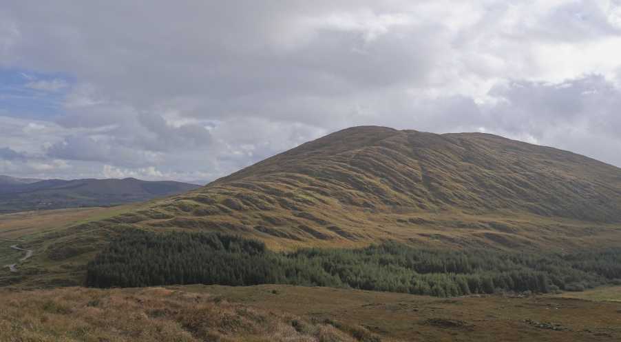
From Killarney, take signposts to Kenmare (the Ring of Kerry route) and at Moll’s Gap take the signposts for Sneem. Keep on the main road, passing Boughil, Cnoc na gCapall, Bascadh and Knocklomena on your right, through one set of crossroads about 6 or 7 miles from Moll’s Gap (you will see the sign for the Blackwater Tavern, of which more below), passsed another turn off to the right that leads to Ballaghbeama. Knocknagullion is the mountain in front and to the left. Drive past it, there are a few places you can park on the opposite side of the road, and a large area for parking just as one goes over its shoulder and is looking down towards the Tahilla/Sneem area. As you pass, keep an eye out for the very distinct fence that runs up its north flank. You will be following this up. Park car and walk back a few hundred metres beyond a small forestry to anywhere around GrtGow Wd (V75180 70730), and leave road. You may have to skirt a small hillock or two but the fence you passed earlier should become obvious pretty quickly. After that it’s a very straightforward but pretty joyless slog across a bog for 40 or 50 mins following the fence, might be a bit wet in places. There are two distinct summits, go over spot height 405 and across another boggy area (watch out, there is bog burst that can be a bit sticky) to a trig point at 411.

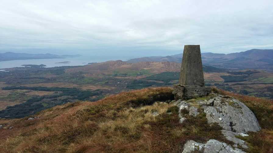
Great views down across Kenmare Bay and towards Sneem on one side and Blackwater/Templenoe on the other, which latter is the parish that wraps around the mountain to the north and goes right up to Ballaghbeama. Sneem was the home of Steve Crusher Casey, former world heavyweight wrestling champion, William Melville, the first head of MI5 and one of a few who stand accused of being the inspiration behind James Bond, and former President Cearbhall O’Dalaigh. Blackwater/Templenoe has the footballing Spillane Brothers, the last Irish Wimbledon winner (check out my review on Mullaghanattin), and of course Big Bertha, the oldest cow in the world and the one who fired out (is that the veterinary term?) the most calves. Now deceased, she lived on a farm to your north, under Mullaghanattin, and her death was one hell of a do in the Blackwater Tavern. The hill on the sea side is Doon, and I had spent a memorable night on its slopes years ago at, of all things, a rave – come on, the topic title was surely a giveaway for any others here born in 1974 or thereabouts!

The real treat is to your north, though the trek isn’t the greatest the view of the full length of the Dunkerrons makes it worthwhile. You can clearly see all the giants of the range, and the deep cooms and valleys that scar them. The walk back down is 15/20 minutes. Linkback: mountainviews.ie/summit/769/comment/6489/
Read Less
Read More

Superb Views. Another excellent route by Conor74.
by three5four0 3 Oct 2011
Parked up at A (V748 703) and walked back to the start of Conor74 route. Followed a fence tightly round a ring contour, then over pt223. A fence runs directly up hill, with a shallow re entrant on its right (west side). I stayed mainly on the left hand side of the fence, perhaps crossing once to avoid some greasy rock. After you reach the first top, its a short walk out to the real summit and the Trig Point, with the only inconvenient thing being that it is a 2 map hill.

Conor74 is spot on about the view, it is indeed a good one. Even though it was blown a hoolie on my visit, I did linger a while to take the view in proper.

From the summit, you can see a forestry track going very close to the East side of the col between pt 272 and pt308 (Doon). And from the map it looks possible to get onto the Kerry way and Black Water Bridge. So, a traverse of the hill maybe possible, and more importantly, the chance of finishing your day with a pint in your hand at the Blackwater Tavern! Linkback: mountainviews.ie/summit/769/comment/6558/
Read Less
Read More

            MountainViews.ie picture about Knocknagullion (<em>Cnoc na gCuileann</em>)
Picture: Viewing the summit from the adjacent Knocknafreaghane.
Rough rock, vast view.
by simon3 24 Oct 2023
For a small summit, Knocknagullion presents a magnificent sight from the west. Visiting from this side can take over an hour to reach the top. Linkback: mountainviews.ie/summit/769/comment/24069/
Read Less
Read More

            MountainViews.ie picture about Knocknagullion (<em>Cnoc na gCuileann</em>)
Picture: Trig pillar at the summit
Longer trek than it seems from below
by Fergalh 9 Jan 2023
Another small hill with extensive views. This hill is very prominent from all roads in the area. Like Conor74 i followed the same route to the first smaller northern summit. Than down over the col to the southern summit with the trig pillar. I doubt there are many higher hills in Ireland with such a wonderful panoramic view Linkback: mountainviews.ie/summit/769/comment/23798/
Read Less
Read More
EDIT Point of Interest
text
Videos


Recent Contributions
x
Conditions and Info
Use of MountainViews is governed by conditions and a privacy policy.
Read general information about the site.
Opinions in material here are not necessarily endorsed by MountainViews.
Hillwalking is a risk sport. Information in comments, walks, shared GPS tracks or about starting places may not be accurate for example as regards safety or access permission. You are responsible for your safety and your permission to walk.
See the credits and list definitions.

OSi logo
OSNI/LPS logo
Open Street Map
(Various variations used.)
British summit data courtesy:
Database of British & Irish Hills