Cookies.
This website uses cookies, which are small text files that the website puts on your device to facilitate operation. Cookies help us provide a better service to you. They are used to track general user traffic information and to help the website function properly.
Features
Nearby features appear when you click the map.
Declutter tracks on map.
Place Search
Video
X
Pub: by
Dartry Mountains Area , SE: Manorhamilton Hills Subarea
Feature count in area: 31, by county: Leitrim: 22, Sligo: 10, of which 1 is in both Sligo and Leitrim, OSI/LPS Maps: 16, 17, 25, 26
Highest Place: Truskmore 647m

Starting Places (22) in area Dartry Mountains:
Aghavoghil Middle, Arroo Trail CP, Ballaghnatrillick, Ballintrillick Forest, Barrs East, Castletown, Crumpaun, Curraghan Road, Dough Mountain NW, Dough Mountain West, Drumcliff River Road, Eagles Rock, Edenbaun, Glencar Waterfall, Gleniff Horseshoe Road, Lough Cloonaquin North, Luke's Bridge, Mountain Wood, Poulveha River, Thur East, Tormore Car Park, Truskmore Transmitter Entrance

Summits & other features in area Dartry Mountains:
N: Truskmore: Gortnagarn 445m, Tievebaun 611m, Truskmore 647m, Truskmore SE Cairn 631m
NE: Arroo Keeloges: Aganny Top 482m, Aghalateeve 432m, Agow Top 423m, Arroo Mountain 523m, Conwal North 421m, Crocknagapple 372m, Keeloges 452m
NW: Benbulbin: Annacoona Top 597m, Benbulbin 526m, Benwiskin 514m, Benwiskin South Top 508m, Kings Mountain 462m
SE: Manorhamilton Hills: Ballaghnabehy Top 413m, Benbo 415m, Dough Mountain 462m, Lackagh Mountain 449m, Larkfield 305m, Naweeloge Top 441m, Thur Mountain 442m
SW: Castlegal Hills: Copes Mountain 452m, Crockauns 463m, Hangmans Hill 400m, Keelogyboy Mountain 438m, Keelogyboy Mountain Far East Top 418m, Keelogyboy Mountain NE Top 435m, Keelogyboy Mountain SW Top 417m, Leean Mountain 417m

Note: this list of places may include island features such as summits, but not islands as such.
Rating graphic.
Benbo, 415m Hill Beanna Bó A name in Irish,
Place Rating ..
(Ir. Beanna Bó [OSI], 'horns of the cow'), Leitrim County in Connacht province, in Carn Lists, Benbo is the 877th highest place in Ireland.
Grid Reference G85083 37726, OS 1:50k mapsheet 16
Place visited by: 48 members, recently by: trostanite, Colin Murphy, abeach, FilHil, GerryCasey, ceadeile, melohara, rollingwave, FrankMc1964, magnumpig, jsg2307, marymac, eamonoc, Wilderness, Sao
I visited this place: NO (You need to be a logged-in member for this.)
Longitude: -8.229826, Latitude: 54.288122, Easting: 185083, Northing: 337726, Prominence: 214m,  Isolation: 4.5km
ITM: 585035 837728
Bedrock type: Granoblastic quartzofeldspathic psammite, (Slishwood Division, Psammitic Paragneiss)
Notes on name: A battle which took place at the foot of this mountain is mentioned in the Annals of the Four Masters under the year 1585. Previously Benbo 1 in MV.
  Short or GPS IDs, 6 char: Benbo, 10 char: Benbo

Linkback: https://mountainviews.ie/summit/761/
Gallery for Benbo (Beanna Bó) and surrounds
Summary for Benbo (Beanna Bó): A small but interesting Hill
Summary created by Colin Murphy, Harry Goodman 2023-05-29 14:44:48
            MountainViews.ie picture about Benbo (<em>Beanna Bó</em>)
Picture: Viewed from the N near Agow Top.
Park at L Cloonqn (G860 366), forestry entrance gate. Walk NE for about 200 metres and as the road swings left look for an entrance on to a muddy lane bounded on each side by a corrugated iron sheet. As off April 2013 there was no gate or temporary structure across the entrance. Walk up through a small field and past some thick whin bushes on the right. At a fence cross over and locate a prominent track going NE (right) up through a copse of trees. The track soon starts to zig zag up out onto the open hillside until it eventually peeters out among some old turf cuttings. Go NW up a steep grass and stoney slope to a notch in the ridge above. Once on the ridge go left up and through a a sheer rocky face to the summit area marked by a cairn. The true summit, marginally higher, appears to lie about 30 metres SW of the cairn. This is an excellent viewing platform which takes in the high Dartry Mts to the NW, the full Castegal Range to the W and across Lough Gill and Sligo Bay to Knockarea and the distant Ox Mts.
An alternative approach starts at A (G84451 36082), where there is parking for 2 cars. Continue N up tarred road watching for a rocky trail on right. This will take up almost all the way to the top of the ridge to approx. B (G84136 37232). Continue NE up gently rising slope (grass & heather) for about 1km, passing two false summits on the way.
Linkback: mountainviews.ie/summit/761/comment/5520/
Member Comments for Benbo (Beanna Bó)
Comment create / edit display placeholder

Ascent via the pallet gate
by Klunk 30 Aug 2010
Head out the Sligo road out of Manorhamilton. Cross the bridge over the Bonet and take the next left towards Dromahair. About a mile down this road you see a galvanise gate on your right with a wee road just beside it. Take this road and after 1/2 mile keep an eye out for a newish 2 storey house on the left. Just after this on the rhs is the 'pallet gate' referred to in earlier posts. Dont attempt to climb it as it is fairly rotten but still serving its purpose. Undo the rope on the rhs of the gate and follow the path up to the lovely oak copse. At this stage I forgot the directions in the earlier posts and just kept going straight up the hill. When you reach the summit of this hill you realise that you must descend again in order to reach the main summit. How bad. A lovely rowan tree, at the base of this unforseen descent, commands the grass beneath to grow a little lusher and one can understand why Oisins mother decides to place her baby under the care of this lovely tree. You see two greenish paths up to the main summit and I chose the one on the right. The sun was beating down on my neck and the steep (for me) ascent enforced many a wee rest to gaze back at the rowan tree. The views at the top were beautiful, mad shapes of mountains altogether. Best of all is the beautiful black lake at the top. Peeled off the sweaty gear and plunged into this lovely lake. Waist deep for me. Dried off letting the lovely breeze do its thing while I gazed all around me. Best walk I have ever had! Linkback: mountainviews.ie/summit/761/comment/6068/
Read Less
Read More

            MountainViews.ie picture about Benbo (<em>Beanna Bó</em>)
Picture: benbo
The John Wayne of the Dartrys
by gerrym 11 Jun 2010
Approached on a a very quiet lane skirting the south of the hill, parking at an old forestry entrance (C (G844 359)) to the SW .

A good track heads uphill nearby, climbing steadily and levelling out above cleared and replanted forestry. Old stone walls provide evidence of different times and lifestyles. A lovely cairn about 4feet high heralds a stone pathway heading directly uphill to steeper higher slopes. This path must have local significance in the past as much effort has went into its construction, with stiles also provided. With height the path becomes rougher and i eventually lost its comforting presence.

Views reach down to Carrigeencor Lough, still water reflecting trees on the shore. A fence is crossed, with the aid of a small stile if you arrive near to it, to reach the summit ridge after 40 minutes walking. Views spring up from all directions - Knocknarea with Maeve's Cairn had twin rays of sunshine either side in an otherwise dull monochrome landscape. A number of cairns mark progress along the top. Black Lough had nothing bright about it today as it stretched out like a halved starfish.

The summit cairn reached in just over an hour. Views are impressive - Castegal Hills, the grown up Truskmore and Tievebaun, Donegal hills, Donegal Bay at the end of Glenade and sun picking out patches of snow atop Cuilcaigh.

Drop down nearly due E towards an area of old turf cuttings, steep drop which picks up a long disused track heading downhill. This descends steeply and roughly as it curls down the hillside to the forest edge, with houses and the river Bonet below. Blooming gorse shouts out its presence in colour before the almost surreal entry into a stand of naked broadleaf trees - just a contrast to the ground covered! Reach road and follow for 20 mins, passing numerous mobile homes which seem to be prevailant in the area.

A great wee walk rounding off a couple of days in the area, easily done in an evening. A rough and rugged hill, with plenty of charm and colour and a bit of bite - like an old gunfighter taking on the big bad old boys in these here parts and coming out on top! Linkback: mountainviews.ie/summit/761/comment/5867/
Read Less
Read More

            MountainViews.ie picture about Benbo (<em>Beanna Bó</em>)
Picture: From left: Benbo's SW Top, Lough Gill, distant Knocknarea, Castlegal Hills, Dartry Mtns.
madfrankie on Benbo
by madfrankie 26 Aug 2009
Benbo is a small but shapely hill, rising above the north Leitrim town of Manorhamilton.
We started from the entrance to forestry ( L Cloonqn (G8600 3660)) on a minor road to the SE at Cloonaquin. Walked back NE, and at a left hand bend in the road climbed over a rickety gate (actually a pallet). A track ascended into a copse of trees, veered right and rose up around a southerly knoll. Crossing a flat area of bog-cuttings, the track deposited us on steep slopes, where it was a brief but steep climb to the summit.
Wonderful views in all directions, encompassing Lough Gill and Sligo Bay, the Castlegal Hills, the Dartry Range, Doagh, Thur, the Glenfarne Plateau and the Cuilcaghs. And from the summit cairn, Manorhamilton a few hundred meters below. Linkback: mountainviews.ie/summit/761/comment/4050/
Read Less
Read More

walking aproach northern and eastern flank
by tinapommer 6 Apr 2010
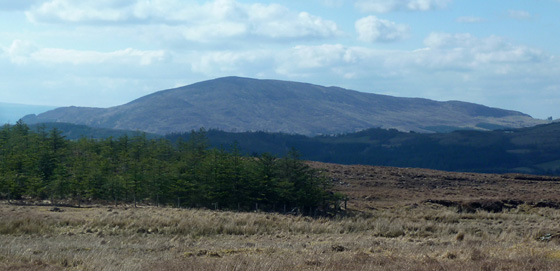
My favourite mountain in this rather stunning area. It is the last outpostpost of the Ox Mountains. Consists of paragneiss and a type of quarzite with the odd garnet seem. The approaches are best from the north eastern flank just up from the Shanvous bridge or up the Benbo road and veer right over the pallet gate into the field after the first big house on the left and meet up with the old turf path. that brings you up steep the eastern lower bump through an oakforest and with great views over the Bonet valley. you`ll be able to pick out some bronze age settlements(round bumps on the valley floor) and if you go left before the forrest ends you`ll pass a wee famine house.
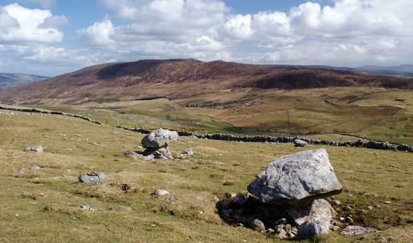
if you stay on the turfroad the trees fall away and you`ll find yourself on the lower bump looking over Manorhamilton onthe north side(more bronze age settlements too) and the high bog valley on the high bog valley(old turf cutting site) on the southern side. there is an unrecorded subcircular enclosure on the southeast side of the high bump and all sorts of interesting walls on the south flank but I usually go arround the northern rim of the bog valley and climb up the green streak to the top fairly hard going but fun. you come out near a ledge hop on that and you get to the little stone pyramid on the top. the legend has it that this side of it was called the hungry side and the farmers from the benbo road used to bring a stone when they went up to gather the sheep.
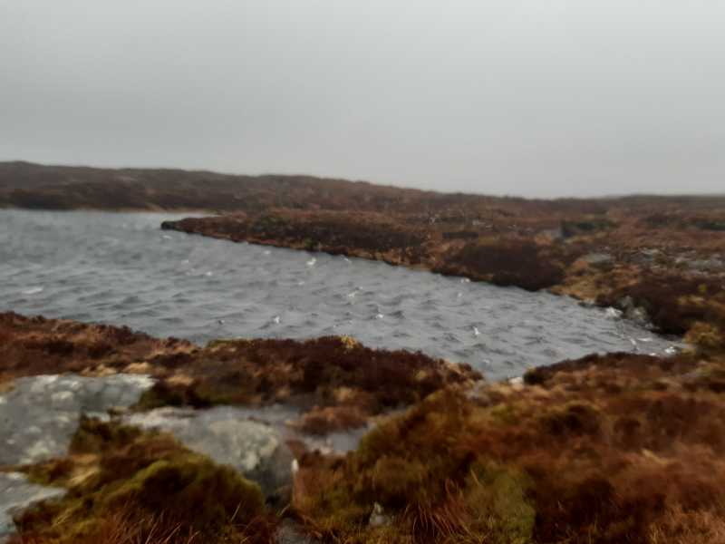
on the very top it round of into rock and tight turf with lots of puddles. keep to the left now and go arround and that will lead you to the black lough. good for swimming in the summer, very shallow and therefore warmish. Used to be full of eels so they say.
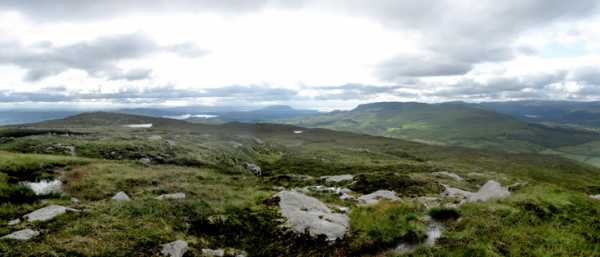
There are amazing turfscapes and really good views up there. Lough Allen,Kesh Mountain and Carrowkeel, Lough Gill, Corrageen Cor, the Dartrys, Truskmore and the Glencar plateau,Crocknagapple,Saddlehill, Dough Mountain, sometimes even Lough McNean .
you can go onto the south west then and if you are lucky you might find a low cairn with an erroded side to the west lining up with a stone to the east and Knocknarea to the southwest. there is another one further west . Going along the rimm untill you find the style over the fence the is decent quickl and easy onto the path rising from sandy lane and follow the Benbo road down to the car again.
The north flank is wet but the prettiest with a bit of hillfort ditch still traversable about halfways up and a little stream running past an old house site and up between the folds of the high bump. lovely clamper but wet. the forrest is indigenous and the botanics stunning.The fauna : hares, foxes, snipes and quails, pheasants, wild goats, lizzards, frogs, a gosshawk and the usual finches and tits. Feet will get wet no matter what you wear. Linkback: mountainviews.ie/summit/761/comment/4595/
Read Less
Read More

            MountainViews.ie picture about Benbo (<em>Beanna Bó</em>)
Picture: Black Lough
Benbo
by GerryCasey 15 Mar 2021
Followed the same route up as gerrym parking at a small forestry barrier at D (G84413 35925) Right next to it is a relatively newly surfaced road leading directly up the hill for about 500M. At that point you turn on to the stone path/track gerrym mentions and follow that up for about another 400/500 metres before it eventually peters out. I continued straight up, crossed a fence and then started for the ridge and summit in a north easterly direction. Weather was awful, cloud, heavy wind and rain making visibility very poor so no views and navigation by sight difficult enough. Passed the lower cairn and Black Lough E (G84884 37563) before reaching the summit after about 70 minutes in total. Descended the same way. Will try it from point A on the map on a better day when there will be better visibility and views Linkback: mountainviews.ie/summit/761/comment/22608/
Read Less
Read More
EDIT Point of Interest
text
Videos

Recent Contributions
x
Conditions and Info
Use of MountainViews is governed by conditions and a privacy policy.
Read general information about the site.
Opinions in material here are not necessarily endorsed by MountainViews.
Hillwalking is a risk sport. Information in comments, walks, shared GPS tracks or about starting places may not be accurate for example as regards safety or access permission. You are responsible for your safety and your permission to walk.
See the credits and list definitions.

OSi logo
OSNI/LPS logo
Open Street Map
(Various variations used.)
British summit data courtesy:
Database of British & Irish Hills