Cookies. This website uses cookies, which are small text files that the website puts on your computer to facilitate operation. Cookies help us provide a better service to you. They are used to track general user traffic information and to help the website function properly.

Click to hide this notice for 30 days.
Welcome to MountainViews
If you want to use the website often please enrol (quick and free) at top right.
Overview
Detail
Zoom: ??
For more map options click on any overview map area or any detail map feature.
Find Suggested Walks
Find hill, mountain, island, coastal feature.
Videos


Recent Contributions
Get Notifications

Muckish: Muckish for the Summits On The Air (SOTA)

Glan Mountain: A Glan rocker......

Easy walk, with nice views towards Eagle Island

Sea Hill: Surprisingly good sea views from this hill

Beenbane: Borreen to heaven

Typical wet North Mayo Coastal Hill

Slieve Fyagh: Gaiter day out

Carrigshouk: Lovely loop

Kilcommon from the west

A Cone with a view

Bweengduff: The Shiddy Way?

Bweengduff: A good forest road to access this summit

Conditions and Info
Use of MountainViews is governed by conditions and a privacy policy.
Read general information about the site.
Opinions in material here are not necessarily endorsed by MountainViews.
Hillwalking is a risk sport. Information in comments, walks, shared GPS tracks or about starting places may not be accurate for example as regards safety or access permission. You are responsible for your safety and your permission to walk.
See the credits and list definitions.
Video display
Sperrin Mountains Area   SW: Mullaghcarn Subarea
Place count in area: 64, OSI/LPS Maps: 12, 13, 6, 7, 8 
Highest place:
Sawel, 678m
Maximum height for area: 678 metres,     Maximum prominence for area: 657 metres,

Places in area Sperrin Mountains:
E: Magherafelt Hills:   Slieve Gallion NE Top 493.6m
E: Magherafelt Hills:   Slieve Gallion 526.6m
N: Claudy Hills:   Crockdooish 321mCurradrolan Hill 270mEglish 277mLetterlogher 249mMullaghmeash Hill 244mSlieveboy 259mStraid Hill 303m
NE Cen: Glenelly North East:   Barnes Top 456mCraigagh Hill 460mCrockbrack 526.1mKnockanbane Mountain 441mMeenard Mountain 620mMeenard Mtn W Top 480mMullaghaneany 627mMullaghash 480mMullaghsallagh 485mOughtmore 569mSpelhoagh 568m
NE: Glenshane North:   Benbradagh 465mBoviel Top 454mCarn Hill 448mCarntogher 464mMoneyoran Hill 414m
NE: Glenshane South:   Bohilbreaga 478mCoolnasillagh Mountain 423mCorick Mountain 430mCrockalougha 407mMullaghmore 550mWhite Mountain 537m
NW Cen: Glenelly North West:   Dart Mountain 619mDart Mountain North-West Top 525mLearmount Mountain 489mLearmount Mountain South Top 492mMullaghasturrakeen 581mMullaghcarbatagh 517mMullaghclogha 635mMullaghclogher 572mMullaghdoo 568mSawel 678m
NW: Maheramason Hills:   Clondermot Hill 220mGortmonly Hill 218mSlievekirk 370m
SE Cen: Glenelly South East:   Carnanelly 562mCarnanelly West Top 503.4mMullaghbane 467mMullaghturk 416m
SE: Cookstown Hills:   Cregganconroe 300mFir Mountain 362mOughtmore 382m
SW Cen: Glenelly South West:   Clogherny Top 408mCraignamaddy 385mCrocknamoghil 335mMullaghbolig 442mSpaltindoagh 420m
SW: Mullaghcarn:   Curraghchosaly Mountain 416mMullaghcarn 542mMullaghcarn South Top 525m
SW: Newtownstewart Hills:   Bessy Bell 420mMullaghcroy 242m
W: Strabane:   Balix Hill 403mKnockavoe 296mOwenreagh Hill 400m

Note: this list of places includes island features such as summits, but not islands as such.
Rating graphic.
Curraghchosaly Mountain Hill Sliabh Churrach Chos Shalach A name in Irish poss. Ir. Sliabh Churrach Chos Shalach [PDT], 'mountain of Currach
Chos Shalach or the bog of the dirty hill-foot’
Tyrone County in NI and in Ulster Province, in Carn List, Psammite & semipellite Bedrock

Height: 416m OS 1:50k Mapsheet: 13 Grid Reference: H47854 83914
Place visited by 50 members. Recently by: Claybird007, Oscar-mckinney, Jai-mckinney, Kirsty, Carolyn105, Leonas_Escapades, wintersmick, pdtempan, trostanite, Hoverla, Wildcat, dregishjake, dregish, Lucky1, eamonoc
I have visited this place: NO (You need to be a logged-in member to change this.)

Longitude: -7.258529, Latitude: 54.700989 , Easting: 247854, Northing: 383914 Prominence: 161m,  Isolation: 4.3km
ITM: 647792 883906,   GPS IDs, 6 char: CrghMn, 10 char: CrghchMntn
Bedrock type: Psammite & semipellite, (Glenelly Formation)

Located NW of Gortin Glen. The origin of the name Curraghchosaly is unclear, but it may be derived from Ir. Currach Chos Shalach, 'bog of the dirty hill-foot’. It refers not to the mountain itself but to a place to the south in the townland of Castleroddy Glebe. This can be compared with Cos Shalach / Cossallagh, Co. Mayo. The anglicised form Curraghchosaly is slightly misleading, as it suggests ch- as in chain. It is sometimes spelt Curraghcosaly, which is preferable in some ways.   Curraghchosaly Mountain is the 874th highest place in Ireland.

Linkback: https://mountainviews.ie/summit/760/
COMMENTS for Curraghchosaly Mountain (Sliabh Churrach Chos Shalach) 1 2 Next page >>  
Follow this place's comments
MountainViews.ie Picture about mountain Curraghchosaly Mountain (<i>Sliabh Churrach Chos Shalach</i>) in area Sperrin Mountains, Ireland
Picture: Curraghchosaly Mountain from Mullaghcarn
 
Long name, short ascent
Short Summary created by Peter Walker  6 Mar 2015
Curraghchosaly Mountain is one of the more westerly of the Sperrins, and faultily apes the higher Mullaghcarn across the B48 with its 50/50 mix of bare slopes and dense forestation. Forest roads hereabouts are being promoted quite heavily as mountain biking venues, and these same thoroughfares provide easy access to the summit, the climb being shortish and very much on the 'steady' side of 'steep'.

Start from (478822 starA) where there is space to park cars at the forest entrance and an assortment of signs and noticeboards for mountain bikers. Follow the forest road north-west into the trees. You will pass two roads branching conspicuously off on the right at (480824 starB) and (482827 starC); after the second of these take the second of two roads branching off on the left in reasonably quick succession at (485828 starD). This writhes uphill for about 600m before bending left and taking a much straighter course for the top, soon noticeable as a transmitter framed within the avenue of trees up which you eventually walk. A lump on the western side of the enclosure is the highest point, but views from here are very arboreally restricted; 200m further west the ground is almost as high but the prospect is much more open. Linkback: https://mountainviews.ie/summit/760/comment/5519/
 
MountainViews.ie Picture about mountain Curraghchosaly Mountain (<i>Sliabh Churrach Chos Shalach</i>) in area Sperrin Mountains, Ireland
pquinn572 on Curraghchosaly Mountain, 2009
by pquinn572  5 Apr 2009
Yesterday, (4/4/09) I attempted to climb Curraghchosaly Mountain near the well known beauty spot, the Gortin Glens which I visit often as a Tyrone man. I turned in left onto a small road off the main Omagh to Gortin road, a few metres down the road from the turn in to the Gortin Glens on the Omagh side. I followed this road on in for about 600m passing a caravan park and over to stoned area on the right side of the road with a gate and a signpost for cyclists. Here I parked the car(Point A: H478822 starA) and began my climb up a steep stoned forestry lane. I continued on up passing another lane which turns down to the right and a water resevoir on the left well hidden by trees and about 100m metres on up on the left side their is a lane leading in to an open area. I continued on up the steep road for another 400 metres, passing another stoned road turning down to the right. I continued on up for another 200m coming to another road on my left hand side, with about 100m on up another road turning up to the left. I took the second of these roads to the left (Point B: H484828 starE) turning off the road I had been on for about a Kilometer and onto a steeper road with trees on the right and deforestation on the left. The surface of this road is bad as the rain has washed a lot of loose stones down. You round the small corner and continue on up for another 200m where the road turns again to the left and continues very steeply on up to another corner. At this corner you get the first glimpse of the great view over tyrone and over to Bessy Bell. At this corner I stopped for a breather and enjoyed the view before turning and being face with another 200m steep climb up to a corner which turns left. At this corner there is a small pad leading over to the back and taking a nosey over I saw there was turf cutting going on. I went back out on to the road and continued on a now straight road on up passing a now blew down lookout post and into the shadow of the trees where the mast for the first time comes into view. Follow the road on up to the top. At the top there is no actual structure marking the exact point but the mast may have been built on it. If you stay at the mast you can enjoy great views of Balix Hill and its windmills and also on out to Donegal but the trees block a lot of the spectacular views so I followed a fence line over through bog to another point that the fence continues over. Here you get a far better view of all of Tyrone, Donegal and the magnificent Sperrin Mountains this is 1m lower that the actual top but here you can enjoy spectactular views. This is a long walk, about 2 miles up hill all the way so you should really consider going up on a good day so that you efforts to get their will be sure to be rewarded. Linkback: https://mountainviews.ie/summit/760/comment/3700/
Your Score: Very useful <<  >>Average
 
MountainViews.ie Picture about mountain Curraghchosaly Mountain (<i>Sliabh Churrach Chos Shalach</i>) in area Sperrin Mountains, Ireland
Picture: On Curraghchosaly top looking west with Bessy Belle in background (left)
 
An easy pleasant walk and my 400th mv top to boot !
by Harry Goodman  26 Jul 2010
Climbed this hill on Fri 23 July 2010. I parked at a forest park entrance H4785382224 starF on a minor road of the B48 between Omagh and Gortin. Having read the comments already posted on the site I anticipated some difficulty in route finding especially as my OSNI Sheet 13 (1999) did not show a track through the forest to the top. I should not have worried as the good quality track we were on led us unerringly up to the communications mast with one or two check points on the way. The first was some 800m into the walk H4844882806 starG where we turned left, rather than continue straight ahead, up an equally good track with trees on the left and cleared forestry on the right. Further up the track turned left passing a lesser peaty track and continued on up to the communication installation at H4788183913 starH, three sides of which are enclosed by the trees. The spot height, as already idenified by simon3, lies on a small hummock along the western edge of the security fence about one or two metres out (west) from the wire at H4785483914 starI. This said the top was not the best vantage point for this hill, surrounded as it was by trees on three sides, this was reserved for a small ring contour at virtually the same height but 200 metres west along a fence line at H4783383913 starJ. The views from this little hillock were simply splendid. NE was the main Sperrins ridge while NW across Balix Hill and Owenreagh Hill (two of the hills to be climbed later in the day) I could clearly identify the Donegal Highlands and further W the Bluestacks. On the return walk down the track the bulk of Mullaghcarn was clearly seen across Gortin Glen. If taking this walk, on the way down at H4824882666 starK, be sure to continue straight on and not take the natural turn of the track down left. Straight on and you are back to the start after 500 metres whereas the turn down left will, after 700 metres, lead down to the B48 and a further 1.5k back to the start. This was a pleasant, easy walk of some 5.3k which I included with three other Sperrins hills later the same day and memorable for me as it marked the 400th mv listed mountain/hill that I have climbed. Since climbing it I have had sight of the OSNI Sheet 13 (2010) which now, unlike my earlier edition, shows the track I followed to the top !. Linkback: https://mountainviews.ie/summit/760/comment/5967/
Your Score: Very useful <<  >>Average
 
MountainViews.ie Picture about mountain Curraghchosaly Mountain (<i>Sliabh Churrach Chos Shalach</i>) in area Sperrin Mountains, Ireland
pquinn572 on Curraghchosaly Mountain, 2009
by pquinn572  6 Apr 2009
Curraghchosaly Mountain Linkback: https://mountainviews.ie/summit/760/comment/3702/
Your Score: Very useful <<  >>Average
 
MountainViews.ie Picture about mountain Curraghchosaly Mountain (<i>Sliabh Churrach Chos Shalach</i>) in area Sperrin Mountains, Ireland
Picture: Looking towards Sliabh Troim / Bessy Bell from the western slopes of Curraghchosaly Mountain
 
Summit easily gained - slower progress to the west
by pdtempan  16 Jun 2021
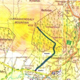
We were looking for a short walk for a Saturday afternoon, and being familiar with Mullaghcarn, decided that it would be worth exploring Curraghchosaly Mountain, its lower neighbour on the west side of Gortin Glen. We parked at the forest entrance in Lislap East at H478822 starA, following pquinn572 and others. From here we followed the forest track steadily uphill until we reached the brow of the hill at
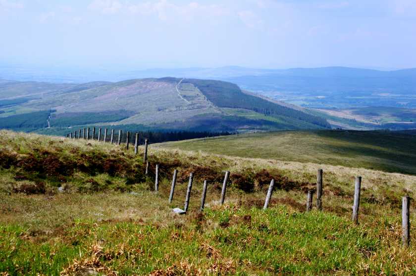
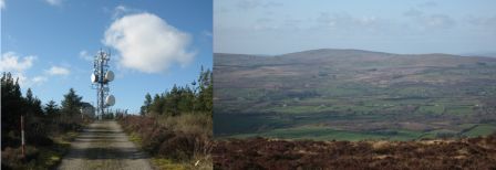
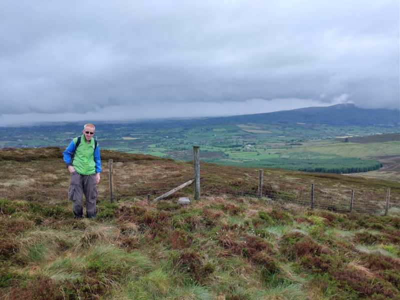
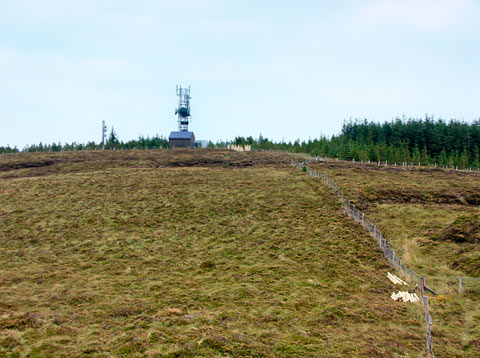
 H489829 starL. We had overshot the left turn recommended by Peter Walker while chatting, but this didn’t cause us any difficulty as there was an obvious grassy forest ride branching left towards the summit. We took this and shortly arrived at a small area of turf cuttings, which we crossed to rejoin the forest road. This led on to the summit. On the way we noticed bilberry bushes in flower on the right-hand side of the road. At the summit we circumvented the transmitter enclosure on the north side, and continued westwards for the more open view, in which Sliabh Troim / Bessy Bell was prominent. The top of Mullaghcarn and the higher peaks of the Sperrins were hidden under cloud.
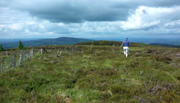
Beyond the summit the going became slower, with only the roughest of paths descending through knee-high heather. We made a short lunch stop at a col H469842 starM, where a path running roughly north-south traverses the ridge. The midges ensured that we didn’t get too comfortable. We then followed this path for a while to the north, coming across some very dense, fluffy patches of bog cotton, then north-west, as it skirted Ballynatubbrit Mountain, leaving it and heading uphill at the point where it began to trend steeply downhill. Pretty soon we reached a fence following the watershed, which led us to the summit of Ballynatubbrit Mountain H463846 starN. This ridge continues further west to the Robber’s Table and Mary Gray before descending to Newtownstewart. However, we aimed south-west from the top of Ballynatubbrit Mountain towards an obvious antenna, picking up a path leading down towards Eskeradooey. At the first farm we joined the road, which brought us momentarily to the west, then south to join Lisnaharney Road. We had 2km of road-walking, heading east along Lisnaharney Road to return to the starting point. The entire trip took about 3¼ hours including 25 mins for lunch. Linkback: https://mountainviews.ie/summit/760/comment/23167/
Your Score: Very useful <<  >>Average
 
MountainViews.ie Picture about mountain Curraghchosaly Mountain (<i>Sliabh Churrach Chos Shalach</i>) in area Sperrin Mountains, Ireland
Picture: Curraghchosaly top from the east
simon3 on Curraghchosaly Mountain, 2008
by simon3  5 Oct 2008
One place to start is from the forest entrance at H49409 83039 starO on the B48 near the crest of the road from Omagh to Gortin. There is notice board here which describes the place as the Start Point for Route A of the Cairn Sunday walk held on the last Sunday in July at 2.30. This is a walk to Mullaghcarn

Getting from this starting point to the tracks that take you to the summit of Curraghchosaly may not be entirely straightforward. The Ulster Way could be used however you would need to descend 60 or 70m and go over 1km to do it. There is also the Altaravan Trail marked as going north along the road and then heading up a slope to reach the forest tracks to the SE of the summit. We could find no sign of the Altaravan Trail however by following roughly its route we got onto the tracks. Go around 200m or so along the road and then strike up the steep bank NW. Head roughly N and you will reach one of the tracks. The ground as of 2008 is rough "clear felled". Head SW along the forest track (it's marked on the 1:50k map). After 700m turn right and go around 320m NE. There is relatively open land there and you can head up and NW. A forest track will appear from the left going in roughly the same direction. Take this and head up.

The summit has a telecoms or broadcasting installation on top of it and forestry. By my reckoning the summit is a hummock just beside the fencing of the installation. There is a minor summit 200m due east of there which appeared to be perhaps 1m lower but hey I only have a fairly ordinary GPS unit so can't be sure
The photo shows the summit from the aforesaid east top. There are also views of the Bessy Bell and its wind turbines. Linkback: https://mountainviews.ie/summit/760/comment/3353/
Your Score: Very useful <<  >>Average
 
COMMENTS for Curraghchosaly Mountain (Sliabh Churrach Chos Shalach) 1 2 Next page >>
(End of comment section for Curraghchosaly Mountain (Sliabh Churrach Chos Shalach).)

OSi logo OSNI/LPS logo
Some mapping:
Open Street Map
(Various variations used.)
British summit data courtesy:
Database of British & Irish Hills
(Creative Commons Licence)
MountainViews.ie, a Hill-walking Website for the island of Ireland. 2300 Summiteers, 1460 Contributors, Newsletter since 2007