Cookies.
This website uses cookies, which are small text files that the website puts on your device to facilitate operation. Cookies help us provide a better service to you. They are used to track general user traffic information and to help the website function properly.
Features
Nearby features appear when you click the map.
Declutter tracks on map.
Place Search
Video
X
Pub: by
Caha Mountains Area , Cen: Knockowen Subarea
Feature count in area: 57, by county: Cork: 32, Kerry: 36, of which 11 are in both Cork and Kerry, OSI/LPS Maps: 83, 84, 85, 88
Highest Place: Hungry Hill 682m

Starting Places (51) in area Caha Mountains:
Ardgroom, Barley Lake North, Bere Island Pier, Caha Pass, Canshanavoe South, Carriganine, Cashelkeelty Stone Circles Carpark, Castletownbere Lifeboat Harbour, Clashduff River Farm, Coolieragh Harbour Road, Coomadayallig Lake Road N, Coomadayallig Lake Road S, Cooryeen Lane, Cummer Lough East Road, Derreenataggart Stone Circle Road, Dromoghty Lough North, Dunboy Wood, Esk Boreen, Eyeries, Fehanah Lane, Garinish Island Pier, Glantrasna Bridge, Glenbeg Lough N, Glengarriff, Glengarriff Nature Reserve CP, Gleninchaquin Waterfall, Gowlaun Lough, Healy Pass, Healy Pass Hairpin, Ilnacullin Car Park, Kenmare Bridge, Knockacullin Lane, Leahill Bog, Leitrim Beg Standing Stone, Lough Inchiquin SE, Magannagan Stream, Molly Gallivan's Visitor Centre, Nora's Cottage, Old Lansdowne School, Owgarriff River Lane, Peg's Shop, Pooleen Wood Car Park, Red Trout Lake, Reenroe Bridge, River Drimminboy Track, Rossmackowen Bridge, Rossmackowen Cemetery, Shronebirrane Farm, Shronebirrane Road, Toberbanaha, Turner's Rock Tunnel

Summits & other features in area Caha Mountains:
Cen: Hungry Hill: Coombane 510m, Derryclancy 554m, Hungry Hill 682m
Cen: Knockowen: Cushnaficulla 594m, Glenkeel Top 417m, Knockastumpa 398m, Knockeirky 577m, Knockeirky South Top 523m, Knockowen 658m, Stookeennalackareha 412m
E: Glengarriff: Derrynafulla SW 375m, Gowlbeg Mountain 362m, Nareera 530m, Nareera North Top 503m, Nareera South-West Top 505m, Shrone Hill 283m, Sugarloaf Mountain 574m, Sugarloaf Mountain Far West Top 560m, Sugarloaf Mountain West Top 565m
N: Coomnadiha: Baurearagh Mountain 489m, Caha Far SE Top 555m, Caha SE Top 585m, Coomnadiha 644m, Coomnalack Top 435m, Cummeenbaun 510m, Droppa 522m, Killane Mountain 537m, Killane Mountain South-West Top 533m, Knockagarrane 414m, Knockreagh 500m
N: Knockeirka: Barraduff Mountain 400m, Killaha Mountain 400m, Knockeirka 426m
N: Knocknagorraveela: Derrysallagh 410m, Feorus East 474m, Knocknagorraveela 507m, Knocknagorraveela NE Top 464m
N: Lauragh: Knockanoughanish 386m, Knockatee 330m
S: Castletownbere: Disert 205m, Knockanallig (Bear Island) 267m
W: Ardgroom: Derryvour Hill 160m
W: Eskatarriff: Coomacloghane 599m, Eskatarriff 600.5m, Eskatarriff East Top 532.7m, Knocknaveacal North Top 509.1m, Knocknaveacal South Top 507.2m, Lackabane 603m, Tooreenbaha 408.7m, Tooreennamna 524m, Tooth Mountain 592m
W: Knocknagree: Knocknagree 586m, Knocknagree East Top 461m, Knocknagree SE Top 442m, Lackawee 572m, Maulin 621m, Maulin North Top 579m

Note: this list of places may include island features such as summits, but not islands as such.
Rating graphic.
Glenkeel Top, 417m Hill Barr an Ghleanna Chaoil A name in Irish,
Place Rating ..
, Cork County in Munster province, in Carn Lists, Glenkeel Top is the 866th highest place in Ireland.
Grid Reference V83982 54152, OS 1:50k mapsheet 85
Place visited by: 18 members, recently by: maoris, Superterence, jackos, annem, John.geary, chelman7, Colin Murphy, eamonoc, Fergalh, chalky, PeakPaul, shaunkelly, simoburn, jcincork, David-Guenot
I visited this place: NO (You need to be a logged-in member for this.)
Longitude: -9.679869, Latitude: 51.7283, Easting: 83982, Northing: 54152, Prominence: 85m,  Isolation: 1.4km
ITM: 483957 554218
Bedrock type: Green-grey sandstone & purple siltstone, (Gun Point Formation)

  Short or GPS IDs, 6 char: GlnkTp, 10 char: GlnklTop

Linkback: https://mountainviews.ie/summit/749/
Gallery for Glenkeel Top (Barr an Ghleanna Chaoil) and surrounds
Summary for Glenkeel Top (Barr an Ghleanna Chaoil): A little gem.
Summary created by Colin Murphy 2021-08-30 15:45:47
            MountainViews.ie picture about Glenkeel Top (<em>Barr an Ghleanna Chaoil</em>)
Picture: Summit to the centre right, seen from Knockeirky S.
Usually done in conjunction with another top, one approach is from Knockeirky South Top (see short summary for that top). From that summit descend the steep grassy slope to A (V834 538), where it is possible to cross the river with care. From there it is a fairy straightforward ascent to the NE, requiring a climb of about 90m over 1km, crossing occasionally boggy ground. Two similarly-sized hillocks border a tiny lough at the summit, the high point being the one to the north. Summit area is a huge slab of rock with a small pile of stones marking the high point. Descent may be made by retracing your steps back over Knockeirky S, or alternatively descending through the valley to the SW, loosely following the Glenkeel River, although great care should be taken if making this descent, which requires one to carefully pick one's path along a series of steeply sloping slabs of sandstone.
Linkback: mountainviews.ie/summit/749/comment/5508/
Member Comments for Glenkeel Top (Barr an Ghleanna Chaoil)
Comment create / edit display placeholder

            MountainViews.ie picture about Glenkeel Top (<em>Barr an Ghleanna Chaoil</em>)
Picture: Glenkeel Lough and Glenkeel Top in the sunshine, from the steep SE slopes of Canshanavoe
Wild and remote-Part One
by David-Guenot 15 Apr 2014
As I was preparing my trip to Béara in March 2014, I noticed there was no comment for Glenkeel Top on MV, and only 3 members had climbed it. Its modest height, the fact that it remains unmarked and on the edge on two OS maps, and most of all its relative isolation from other MV summits are the main reasons. Intrigued, I decided to include it in a circular walk, starting from the Healy Pass, taking in Knockowen, Cushnaficulla, Knockeirky, Glenkeel Top, then back to Knockowen via Knockeirky's S ridge (Canshanavoe), down to Stookeennalackareha and up the road back to the Pass.
From Knockeirky, I descended SSE, on rocky, then soft, boggy ground, facing Glenkeel Top in the distance, until I reached the end of a small finger-shaped lough at 
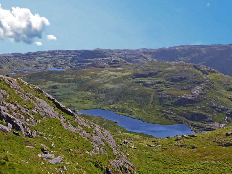
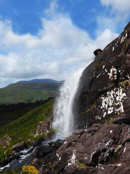
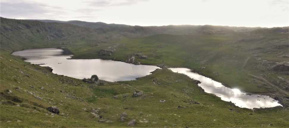
B (V836 551). I then followed the cliffs' edge to the E, enjoying the beautiful scenery over Glenkeel Lough until I found a convenient route to go down, avoiding the cliffs. Reached a low point crossing a stream beneath a small waterfall at approx. 
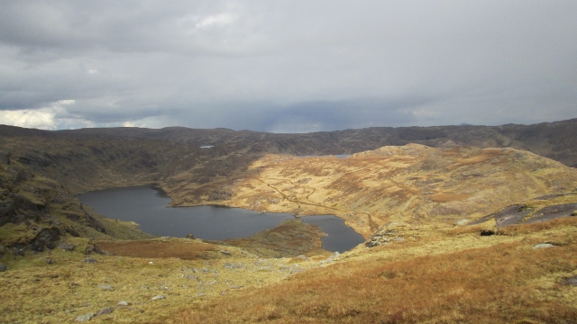
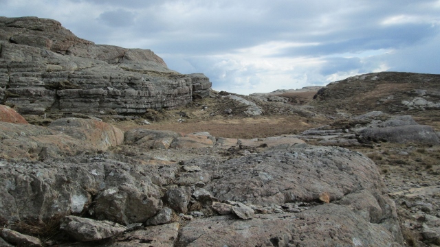
C (V837 546) and started ascending on boggy, slippery ground. I soon reached a shoulder which led me underneath the rocky summit ridge (see pic in Part Two). A short pull-up took me to the top. The summit area consists in a large, flat slab of red rock. The higher point lies on the southern end of this slab. There is also a minor top to the S, which I first thought was higher. The views from the top are really enjoyable, even though higher mountains bar the horizon. Loughs, cliffs, and a beautiful view towards Bantry Bay (best seen from the minor top). But most striking is the wilderness and remoteness of the whole area, particularly to the N of the summit. Not a single trace of human activity, no road, building or poles, no path, fence or posts, it was just me, rocks, bogs and water !! Only from the minor top were a few houses down in Adrigole merely visible. And then there was this small "dam" made of concrete blocks to the S end of Glenkeel Lough. I reached this point after a few minutes' descent, and was helpfully guided by a few sheep who escaped from me upon this line of blocks to the other side of the lough. From there I ascended "Canshanavoe", taking time to look back at the beautiful scenery over Glenkeel Lough and Top, with Glenlough Mountain in the background. I veered slightly SW and after a 30 minutes' climb, reached a flat area of long, flat slabs of rock and got stunned by the spectacular views: to the SE, the impressive SW cliffs of Glenlough Mountain; to the S, Bantry Bay and Adrigole Harbour; and to the SW, the massive, cloud-covered outline of Hungry Hill, which amazingly looked like an erupting volcano !! Another 10-15 minutes climb to the N then led me to pt. 523m, where I stopped for a snack, enjoying the beautiful scenery to the NE. Large patches of sunshine were peering through heavy clouds, enhancing the colours of the moor, before the clouds finally won the race and it started snowing. Linkback: mountainviews.ie/summit/749/comment/16010/
Read Less
Read More

            MountainViews.ie picture about Glenkeel Top (<em>Barr an Ghleanna Chaoil</em>)
Picture: Approaching the red rocky summit (left), minor top to the right
Wild and remote - Part Two
by David-Guenot 15 Apr 2014
Then started the long slog back to Knockowen along the Canshanavoe ridge. The snow soon stopped and melt immediately, and despite a few detours to avoid some peat hags, ponds and the usual boggy patches, the going was relatively easy until I reached the SW slopes of Knockeirky. It was now a matter of finding my way across long slabs of rocks, separated by narrow but soggy lines of grassy ground. Crossed a stream S of Cushnaficulla and began my second ascent of the day of Knockowen, on boggy, slippery ground first, then again across large bands of rock. Reached the top of the "Spine" about 1h15 after I had left pt. 523m on Canshanavoe. Next (and last) target of the day: Stookeennalackareha (see comment on this summit for end of the walk).
As a conclusion on Glenkeel Top: definitely to be taken as part of a longer route, and worth the detour, as the surroundings are beautiful and remote. Linkback: mountainviews.ie/summit/749/comment/16011/
Read Less
Read More

            MountainViews.ie picture about Glenkeel Top (<em>Barr an Ghleanna Chaoil</em>)
Picture: One of the many waterfalls encountered along the way.
Tricky but spectacular descent.
by Colin Murphy 13 Sep 2021
Having bagged Glenkeel Top from Knockeirky South, rather than retracing my steps, I decided to take the more adventurous route down, roughly following the Glenkeel River. I picked up a good track just east of the river crossing at A (V834 538) and followed this as it meandered back and forth across the water, however aware that it ended in a farmyard, and nervous of encountering a farmer, I left the track at D (V838 535) and turned SW, wading through waist high grass and reeds for a time, crossing the river again and then following a series of huge stone slabs which form the SE side of Knockeirky South. The multiple waterfalls I saw were quite spectacular, but great care was needed in the ascent, and several times I had to backtrack to find safer ways to clamber down onto the next slab. Eventually I reached the relative safety of a field (sheep-filled) at E (V833 530). I crossed this, then had to battle with some brambles and cross another minor stream to reach the short track at F (V834 529), which took me back to the road. Would not recommend this descent in poor conditions. You have been warned! Linkback: mountainviews.ie/summit/749/comment/23256/
Read Less
Read More

            MountainViews.ie picture about Glenkeel Top (<em>Barr an Ghleanna Chaoil</em>)
Picture: Glenkeel Lough
A bit of a gem this one.
by eamonoc 4 Jul 2021
Would highly recommend a visit to Glenkeel Top. A hill situated amidst some fantastic scenery, I approached from Knockeirky without any great difficulty. Best saved for a good weather day, descent made by a green road situated under the steep south face of Knokierky. See track 4518 Linkback: mountainviews.ie/summit/749/comment/23202/
Read Less
Read More
EDIT Point of Interest
text
Videos

Recent Contributions
x
Conditions and Info
Use of MountainViews is governed by conditions and a privacy policy.
Read general information about the site.
Opinions in material here are not necessarily endorsed by MountainViews.
Hillwalking is a risk sport. Information in comments, walks, shared GPS tracks or about starting places may not be accurate for example as regards safety or access permission. You are responsible for your safety and your permission to walk.
See the credits and list definitions.

OSi logo
OSNI/LPS logo
Open Street Map
(Various variations used.)
British summit data courtesy:
Database of British & Irish Hills