Cookies. This website uses cookies, which are small text files that the website puts on your computer to facilitate operation. Cookies help us provide a better service to you. They are used to track general user traffic information and to help the website function properly.

Click to hide this notice for 30 days.
Welcome to MountainViews
If you want to use the website often please enrol (quick and free) at top right.
Overview
Detail
Zoom: ??
For more map options click on any overview map area or any detail map feature.
Find Suggested Walks
Find hill, mountain, island, coastal feature.
Videos


Recent Contributions
Get Notifications

Corranabinnia: A Remote Mountain to Respect and Admire

The Bones Peak: On Beenkeragh Ridge

Bawn Mountain: Crouching Tiger Hidden Trig

MacGillycuddy's Reeks: The Three Arêtes

Focussed Summiteering Circuit.

Rocky Island: North face conquered and no acclimitisation needed

The Saddle - Trig Point: View From Summit

The Ben Starav Five

An Teallach - Bidein a'Ghlas Thuill: View From Summit

Slioch: On Summit, August 2023

Ben Starav: Loch Etive

Figure of eight from Shay Elliott.

Conditions and Info
Use of MountainViews is governed by conditions and a privacy policy.
Read general information about the site.
Opinions in material here are not necessarily endorsed by MountainViews.
Hillwalking is a risk sport. Information in comments, walks, shared GPS tracks or about starting places may not be accurate for example as regards safety or access permission. You are responsible for your safety and your permission to walk.
See the credits and list definitions.
Video display
Antrim Hills Area   Cen: Central Antrim Hills Subarea
Place count in area: 27, OSI/LPS Maps: 14, 15, 4, 5, 8, 9 
Highest place:
Trostan, 550m
Maximum height for area: 550 metres,     Maximum prominence for area: 515 metres,

Note: this list of places includes island features such as summits, but not islands as such.
Rating graphic.
Slievenahanaghan Hill Sliabh na hAnachaine A name in Irish Antrim County in NI and in Ulster Province, in Carn List, Olivine basalt lava Bedrock

Height: 418m OS 1:50k Mapsheet: 9 Grid Reference: D11667 21884
Place visited by 40 members. Recently by: garybuz, Paddym99, Colin Murphy, chelman7, Hoverla, pdtempan, Andy1287, Kirsty, Vfslb1904, Kilcoobin, LorraineG60, Kilcubbin, MichaelG55, eamonoc, Ulsterpooka
I have visited this place: NO (You need to be a logged-in member to change this.)

Longitude: -6.254433, Latitude: 55.03181 , Easting: 311667, Northing: 421884 Prominence: 73m,  Isolation: 2.4km
ITM: 711591 921868,   GPS IDs, 6 char: Slvnhn, 10 char: Slvnhnghn
Bedrock type: Olivine basalt lava, (Lower Basalt Formation)

Slievenahanaghan is the 858th highest place in Ireland.

Linkback: https://mountainviews.ie/summit/741/
COMMENTS for Slievenahanaghan (Sliabh na hAnachaine) 1 of 1  
Follow this place's comments
MountainViews.ie Picture about mountain Slievenahanaghan (<i>Sliabh na hAnachaine</i>) in area Antrim Hills, Ireland
Picture: The small marker at summit
 
Unremarkable summit covered in windmills
Short Summary created by Colin Murphy  23 Sep 2022
Parking for 2 cars next to entrance to Gruig Windfarm at D13282 21721 starA. The wind farm entrance features a high gate and fencing. There is a farm gate adjacent to the parking spot. By crossing this into a field and turning west, it is possible to access the wind farm road, although if there is anyone about, you should ask permission. Follow the road west up to a fork and take the road to the right. Follow this up to its highest point, roughly D12037 21432 starB, then turn NW, directly up the hillside for 500m through long grass and heather, which makes it a bit of a slog. The summit is rounded and flattish and features windmills, although there is a small stone marker at what appears to be the high point. 1 hour 20 minutes should see you up and down. Linkback: https://mountainviews.ie/summit/741/comment/5500/
 
MountainViews.ie Picture about mountain Slievenahanaghan (<i>Sliabh na hAnachaine</i>) in area Antrim Hills, Ireland
Picture: Swooshing sentinels study your sojourn on Slievenahagan
Pondering the name of this hill
by wicklore  16 Apr 2010
Slievenahanaghan caught my attention as it shares a name with Lough Nahanaghan in Wicklow. Lough Nahanaghan close to the Wicklow Gap became a part of the somewhat famous Turlough Hill hydroelectric power station, which was completed in 1974. I know of a story about how St Kevin drove a lake monster from one of the lakes in Glendalough in the 5th century, and it ended up in what became known as Lough Nahanagan. The story claims that ‘Nahanaghan’ essentially means ‘lake monster’, and that the lake was named for the creature living in it. However another source says that Lough Nahanaghan comes from Loch na h-Onchon, meaning ‘Lake of the otters’

Perhaps in the past Slievenahanaghan had otters or some other creature connected to it? I saw neither lake monsters nor lake otters when I set out to stroll up the access road (D 13269 21727 starC) referred to by Harry Goodman in his post. There are now 20 turbines on the slopes and at the summit. The good news is that all of the warning signs described by Harry Goodman prohibiting access have been removed, and there only remains a plea not to block the access gate. The access road passes directly under a couple of the turbines and it was a bit disorienting to stand beneath one and watch the massive blades cutting through the air as it swooshed directly down towards me. The blades must be over 40 feet long each, although they don’t come within about 60 feet vertical distance. It was still a relief to quickly move on.

This access road eventually curves around the back of the hill so it was necessary to head off the track uphill to cross the bog to the summit. There are many drainage channels in the area to be negotiated, and a sturdy fence to cross at the summit. The summit itself is as described by others – an unremarkable area comprising of turbines, service tracks and little else. I particularly enjoyed the view of the nearby Slieveanorra Forest which is quite extensive. An army helicopter was buzzing back and forward over the forest when I was there last Friday. From the summit I made a beeline SE down to the first turbine on the access track and completed the whole walk in about an hour.

One thing I liked about this hill was reaching it using the lonely bog roads in the area. Having earlier climbed Trostan and a couple of others I was surprised at how quiet the roads and mountains were. (excluding the helicopter). So if you can ignore the 20 turbines you could enjoy a type of solitude here. Also an understanding of the origin of the name of the hill, and any connection to creatures real or imagined, could help us to understand the similarity of its name with Lough Nahanaghan in Wicklow. Linkback: https://mountainviews.ie/summit/741/comment/4624/
Your Score: Very useful <<  >>Average
 
MountainViews.ie Picture about mountain Slievenahanaghan (<i>Sliabh na hAnachaine</i>) in area Antrim Hills, Ireland
Picture: wind turbine on summit
 
gerrym on Slievenahanaghan, 2007
by gerrym  10 Nov 2007
Driving through the lonely mountain roads I was surprised to come across a veritable carpark of vehicles near to Slieveanorra Forest. I then remembered that the Glens of Antrim rally was sceduled for this weekend. I took an hour to spectate and listen to the tortured sounds of engines and the staccato fire from exhausts, reverberating like shotguns and machineguns through the forest, like a full blown battle.
Parking at service road for Altnahinch Dam (
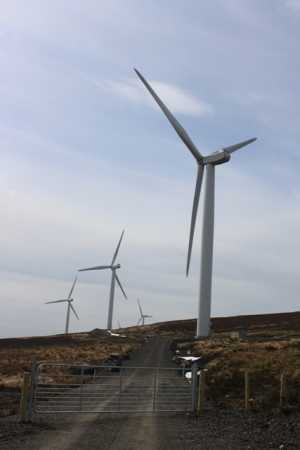
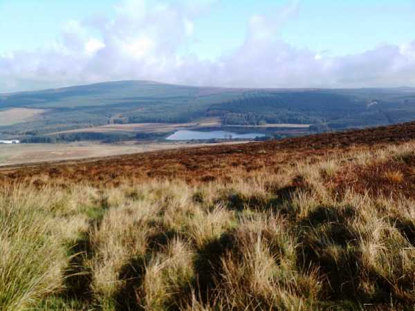
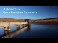
117235 starD), can also park at dam itself but a sign says 'anglers only'. From here walk left to the nearby road junction and head onto open ground, crossing a Burn which disappears under the road through a stone arch. The hill is straight ahead, with a gaggle of wind turbines adding to its height. Ground is pretty good but wet and soft in places. As walk further uphill views back over the beautifully framed resevoir dominate. A couple of fences and some deep heather near the top bring the summit after a half hour.
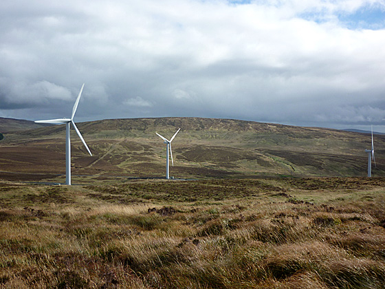
The top is long and broad and eleven wind turbines where busily slicing thickly through the air, like the engines on a massive airship that was about to lift off. Despite the calm, the movement of so many large wind turbine blades through the air made it sound as if a gale was blowing. There are good views from the top - to the N a line of 500m + rounded hills from Knocklayd to Slieveanee. To the W the long line of the Sperrins were just visible through the murk. It took me 15 minutes to dander along the service track between the turbines before dropping off the SE side of the hill.
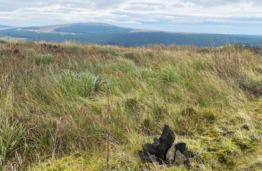
A large tracked vehicle has flattened the heather here to reach an almost invisible radio mast (some scientific purpose perhaps given the numerous white plastic poles in the surrounding ground?). The occasional noise of the rally cars was the only intrusion, apart from the few birds i disturbed. I followed a small stream downhill before climbing gradually up towards Skerry Hill (459m). Cattle were grazing on the lower slopes and thier presence was evident amongst the rough ground on the way to the summit. A small cairn covered in moss showed the top and I followed a fence along and down to the N for a while,continuing N when it turned. A drop brings the road and a walk of a half hour back to the car. It was dark now and the rally cars were having thier final run up and through the sprawl of forest.
Something different than the usual higher hills but interesting. The day showed the variety of uses that the heights can be put to and the different activites that can be accomodated in our upland. Linkback: https://mountainviews.ie/summit/741/comment/2894/
Your Score: Very useful <<  >>Average
 
MountainViews.ie Picture about mountain Slievenahanaghan (<i>Sliabh na hAnachaine</i>) in area Antrim Hills, Ireland
Picture: Loking SE to Skerry Hill from the slopes of Slievenahanaghan
Harry Goodman on Slievenahanaghan, 2009
by Harry Goodman  24 Sep 2009
I climbed Slievenahanaghan' as part of a round which had earlier included Skerry Hill, approaching it from the SE across rough moorland of knee high gorse and clumps of tussocky grass. On my way I came across an access road not marked on the OSNI maps which would be of considerable help to anyone looking for a less torturous approach to the hill. The entrance gate is at D 13269 21727 starC. I should add that there is a warning sign at the gate advising that you are entering a "hard hat site" and another states that there is "no unauthorised entry" However on my way down from the hill, before I was aware of the signs, I was approached by the driver of one of the site vans but his only interest was about my walk and not to warn me off the site. I suspect that no one will object to a walker using this track to access the hill at her/his own risk but if in doubt permission could be sought at the site office located about 1k in from the public road. I climbed the hill directly by keeping to the right side of the wind turbines. There is nothing to mark the top. Indeed the high point is on a large flat area levelled out to facilitate work when building the wind farm. Gerrym may be interested to know that since he filed his comments on 07-11-10 the number of turbines has increased from 11 to at least 18. Indeed the hill could well be re-named the "Birthday Cake" with its liberal covering of white "candles" !! From the top I dropped down SE past the turbines to the access road where I turned left and followed it out to the public road. From there I turned right and had a short walk along the road to my starting point for the round at D 14285 21327 starE (see also my comments on Skerry Hill) Linkback: https://mountainviews.ie/summit/741/comment/4130/
Your Score: Very useful <<  >>Average
 
MountainViews.ie Picture about mountain Slievenahanaghan (<i>Sliabh na hAnachaine</i>) in area Antrim Hills, Ireland
Picture: A turbine-free view looking north-east from Slievenahanaghan to Slieveanorra forest
 
slemish on Slievenahanaghan, 2009
by slemish  16 Oct 2009
The only previous time I had climbed Slievenahanaghan was many years ago when there was only 1 wind turbine on the hill. Nowadays as Harry Goodman notes there are an incredible 18 of the things. I wanted more of a challenge than walking round the wind farm access road so I climbed from the hill's western side. I drove up the Altnahinch road from Ballura and parked at the gate for the access road to what was the original turbine on Slevenahanaghan (104230 starF). Staying off the gravel track I proceeded up towards the large flat summit area. Hard enough going on the ascent with the usual floating bog, hidden drainage ditches etc to look out for. At the 418m summit there is no obvious mark such as a cairn, although one of the turbines is very close to the highest point. Views aren't brilliant due to Slievenahanaghan being bounded on three sides by higher mountains - Slieveanorra, Trostan and Skerry Hill. There is a good view to the west over the wind farm on Long Mountain and towards the Sperrins and also to the north-east overlooking Altnahinch dam with the vast Slieveanorra forest behind. I walked around on top for a while before descending by the same route - a pleasant enough stroll but not the most exciting hill I've ever climbed. Still another one ticked off anyway. Total trip - about 45 minutes. Linkback: https://mountainviews.ie/summit/741/comment/4211/
Your Score: Very useful <<  >>Average
 
(End of comment section for Slievenahanaghan (Sliabh na hAnachaine).)

OSi logo OSNI/LPS logo
Some mapping:
Open Street Map
(Various variations used.)
British summit data courtesy:
Database of British & Irish Hills
(Creative Commons Licence)
MountainViews.ie, a Hill-walking Website for the island of Ireland. 2300 Summiteers, 1460 Contributors, Newsletter since 2007