This website uses cookies, which are small text files that the website puts on your device to facilitate operation. Cookies help us provide a better service to you. They are used to track general user traffic information and to help the website function properly.
Sperrin MountainsArea, SW Cen: Glenelly South West
Subarea
Feature count in area: 64, by county: Derry: 34, Tyrone: 39, of which 9 are in both Derry and Tyrone,
OSI/LPS Maps: 12, 13, 6, 7, 8
Highest Place: Sawel 678m
Starting Places (21) in area Sperrin Mountains: Altinure Road, Banagher Glen Nature Reserve, Barnes Gap Car Park, Crocknakin, Drumnaspar Picnic CP, Glenchiel Road, Glenedra Bridge, Glenelly Road, Parkreagh, Goles Road, Lough Ouske, Moneyneany Village, Moydamlaght Forest, Moydamlaght Road, Mullaghmore, Mullaghbane, Spaltindoagh, Sperrin Hamlet, Sperrin Heritage Centre, Sperrin Heritage Centre W, Sperrin Road, Barnes Top, Sperrin Road, Glashagh Bridge, Sperrin Road, Sperrin
Summits & other features in area Sperrin Mountains: E: Magherafelt Hills: Slieve Gallion NE Top 493.6m E: Magherafelt Hills: Slieve Gallion 526.6m N: Claudy Hills: Crockdooish 321m, Curradrolan Hill 270m, Eglish 277m, Letterlogher 249m, Mullaghmeash Hill 244m, Slieveboy 259m, Straid Hill 303m NE Cen: Glenelly North East: Barnes Top 456m, Craigagh Hill 460m, Crockbrack 526.1m, Knockanbane Mountain 441m, Meenard Mountain 620m, Meenard Mtn W Top 480m, Mullaghaneany 627m, Mullaghash 480m, Mullaghsallagh 485m, Oughtmore 569m, Spelhoagh 568m NE: Glenshane North: Benbradagh 465m, Boviel Top 454m, Carn Hill 448m, Carntogher 464m, Moneyoran Hill 414m NE: Glenshane South: Bohilbreaga 478m, Coolnasillagh Mountain 423m, Corick Mountain 430m, Crockalougha 407m, Mullaghmore 550m, White Mountain 537m NW Cen: Glenelly North West: Dart Mountain 619m, Dart Mountain North-West Top 525m, Learmount Mountain 489m, Learmount Mountain South Top 492m, Mullaghasturrakeen 581m, Mullaghcarbatagh 517m, Mullaghclogha 635m, Mullaghclogher 572m, Mullaghdoo 568m, Sawel 678m NW: Maheramason Hills: Clondermot Hill 220m, Gortmonly Hill 218m, Slievekirk 370m SE Cen: Glenelly South East: Carnanelly 562m, Carnanelly West Top 503.4m, Mullaghbane 467m, Mullaghturk 416m SE: Cookstown Hills: Cregganconroe 300m, Fir Mountain 362m, Oughtmore 382m SW Cen: Glenelly South West: Clogherny Top 408m, Craignamaddy 385m, Crocknamoghil 335m, Mullaghbolig 442m, Spaltindoagh 420m SW: Mullaghcarn: Curraghchosaly Mountain 416m, Mullaghcarn 542m, Mullaghcarn South Top 525m SW: Newtownstewart Hills: Bessy Bell 420m, Mullaghcroy 242m W: Strabane: Balix Hill 403m, Knockavoe 296m, Owenreagh Hill 400m
Note: this list of places may include island features such as summits, but not
islands as such.
Spaltindoagh, 420mHill
Place Rating ..
, Tyrone County in Ulster province, in Carn Lists, Spaltindoagh is the 851st highest place in Ireland.
Grid Reference H62757 89550,
OS 1:50k mapsheet 13 Place visited by: 31members, recently by: Colin Murphy, Paddym99, garybuz, Jai-mckinney, Kilcoobin, Oscar-mckinney, Carolyn105, dregish, Hoverla, trostanite, LorraineG60, MichaelG55, eamonoc, Fergalh, madfrankie
I visited this place: NO (You need to be a logged-in member for this.)
Short or GPS IDs, 6 char: Spltnd, 10 char: Spltndgh Linkback: https://mountainviews.ie/summit/737/
Gallery for Spaltindoagh and surrounds
Summary
for Spaltindoagh :
Easy ascent to dull top
Summary created by Colin Murphy
2023-12-07 15:20:25
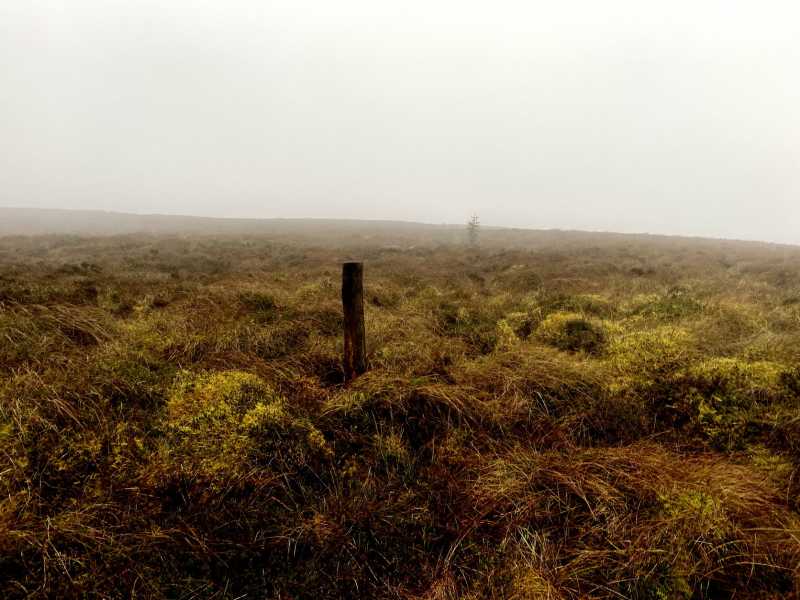
Picture: The high point
One approach is from a farm gate at A (H64276 89757) where there is parking for one car without blocking the gate. Previous walkers have had no access issues but if there is anyone about you should ask permission. To the left of the gate is a quad track. Follow the quad track up into a gently sloping grassy field, taking you up to about 360m. The track swings more to the west through some rougher ground and makes walking easier. Eventually it peters out as you approach some trees at B (H63414 89931) at about 400m elevation. You will see two gateposts with no gate but with wire strung between them. Cross one fence on your left and follow another fence SW for about 1km. The ground is rougher here – clumps of grass initially and then boggy, short grass, reeds and some heather – but is quite navigable without too much effort. The high point is a slightly elevated turf mound with a wooden pole.
There is a lack of available parking places on the narrow road, below Spaltindoagh, that don't involve blocking a gate or lane way. However, just past the new bridge at C (H640 884), there is enough room to park off road and not block the lane way to an old abandoned farm house.
From here turn left and go through the gate, into the lane, then turn right over rough ground and follow the forest edge up hill (do not go through a closed gate here, as you will end up in a fenced off bog hole!). Continue uphill passing through an old open gate, still following the forests edge (crossing a fence on the way) to the top corner(cross another fence here ). After the forest follow a fence uphill to a fence junction on the crest of the hill, turn left and walk to the small ring contour that is the summit. Great views again, but heavy going through the heather, reeds and tussocky ground to get here, leading one to think gerrym's route may be the best approach. Linkback: mountainviews.ie/summit/737/comment/3859/
Read Less
Read More
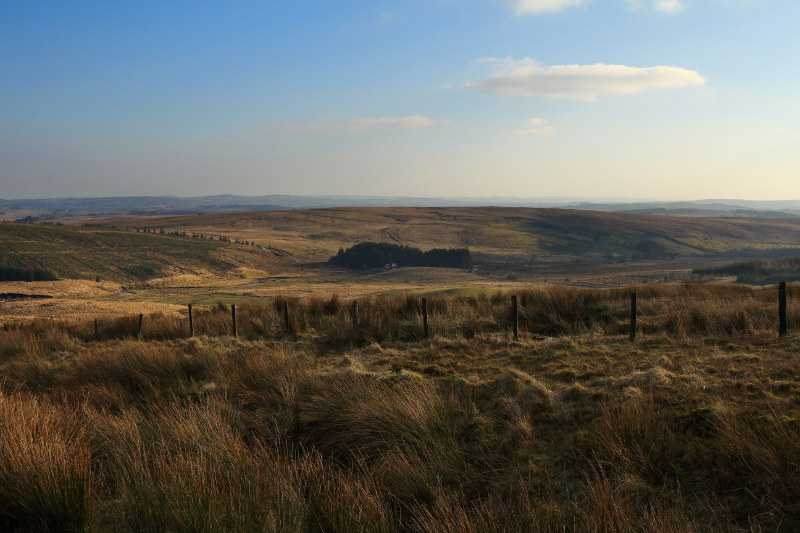
Picture: Views south from near the starting point.
Good Views But Great Views Getting There
by Aidy
25 Mar 2016
Took almost exactly the same route as sandman for a quick, easy walk. The best of the views from the summit are to the south, with the Glenelly Valley being hidden, and only the tops of the higher Sperrins appearing above the forestry to the north. It would have been worth coming here alone for the drive along the southern side of the Glenelly Valley, the road climbing high above it and providing stunning views. Linkback: mountainviews.ie/summit/737/comment/18472/
Read Less
Read More
Picture: top from SW
gerrym on Spaltindoagh
by gerrym
20 Mar 2008
I reached this top by a rather roundabout and arduous path but this need not be the case - there being easy enough access from NE and SW as my own path took me and other options jump out from the 1:25,000 map. The roundabout route can be seen in the comments for Mullaghbolig and Clogherny Top. Back to the matter at hand - i had a 20 min walk along the road through Glenlark forest, past little Lough Lark where i caused 3 ducks to take flight, to get the other side of Glenlark valley. As the road emerges from the forest take the fence SW bordering the trees. Heading for the rise here will cut out a dogleg in the fence, saving some time over wet but not too difficult ground rejoining the fence at a pair of old concrete gate posts where i stopped for some fuel. The cool breeze showed the true nature of the time of year that the strong sunshine was trying to hide.There is a long but gradual rise to the top with views impressive to the N where the higher sunlit Sperrins were towering over the immediate forest. From the top i was yet again smacked in the gob by the far reaching sights - peeks at the Antrim & Belfast hills, the Mournes and Cooleys, the long line of the high Sperrins to the N and the Bluestacks beyond the mouth of the Genelly valley to the W. I dropped down along forest for a mile or so on good ground before heading down through the trees where machinery had been at work. This brought me to a forest track paralleling the river further below. I saw a rare bird here - a gazelle helicopter which chattered along just above the tree tops above the noise of my ipod. Light was disappearing quickly and the near full moon was getting brighter in the sky as the sun dipped. I followed the track to a narrow road which continued to fall towards the river and a left turn onto the Gorticashel rd. The road was closed at Glenlark bridge (which is being rebuilt) but on i went climbing again before turning up onto the shoulder of Mullaghbolig (through farm buildings). This is a steady climb and with the strong moonlight under a clear sky i did not need my headtorch - fantastic and worth all the hours of walking beforehand. Barnes Gap comes and goes and the carpark i set out from some 7 hours and 18.5 miles earlier. Linkback: mountainviews.ie/summit/737/comment/3007/
Read Less
Read More
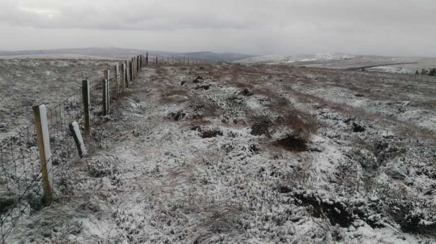
Picture: Summit Area.
Last of the Northern Ireland Summits.
by sandman
3 Dec 2015
Unless Mountain Views locates some more summits this hill completes my summits of Northern Ireland as the first snow of the 2015/2016 winter season falls in the Sperrins. Parking at A (H64276 89757) take the gate summit side and follow a faint quad track to B (H63414 89931) now at the gate piers without a gate follow the fence to summit area easy going thru out walk. Linkback: mountainviews.ie/summit/737/comment/18392/
Use of MountainViews is governed by conditions and a privacy policy.
Read general information about the site. Opinions in material here are not necessarily endorsed by MountainViews.
Hillwalking is a risk sport. Information in comments, walks, shared GPS tracks or about starting places may
not be accurate for example as regards safety or access permission. You are responsible for your safety and your permission to walk.
See the credits and list definitions.


 Our Facebook page.