This website uses cookies, which are small text files that the website puts on your device to facilitate operation. Cookies help us provide a better service to you. They are used to track general user traffic information and to help the website function properly.
Feature count in area: 28, all in Mayo,
OSI/LPS Maps: 22, 23, 30, 31, CBW, EW-ACC, EW-WNN, EW-WNS
Highest Place: Slieve Carr 721m
Starting Places (24) in area Nephin Begs: Altnabrocky Adirondack Shelter, Bellanaderg Bridge, Brogan Carroll Bothy, Bunnahowna Bridge, Bunnahowna River, Burrishoole Loop, Cloondaff Church, Deel River, Furnace Lough E, Glasheens River, Glendahurk Bridge, Glennamong Bridge, LFeeagh E Treenbeg Cottage, LFeeagh E Treenbeg School Ruin, Lough Avoher Hut, Lough Feeagh, Lough Gall NW Mayo, Loughanawillan Loughs Track, Mulranny Post Office, R312 Boghadoon, R312 Prughlish, Srahduggaun, Tarsaghaunmore River, Wild Nephin Wilderness
Summits & other features in area Nephin Begs: Cen: Glennamong: Bengorm 582m, Bengorm NW Top 468m, Corranabinnia 716m, Corranabinnia SW Top 687m, Glennamong 628m, Glennamong East Top 415m, Tirkslieve 401m Cen: Nephin Beg: Aroher Hill 285m, Lettertrask 279m, Nephin Beg 627m, Nephin Beg South Top 410m E: Birreencorragh: Birreencorragh 698m, Birreencorragh South Top 564m, Birreencorragh West Top 551m, Buckoogh 588m, Bullaunmore 388m, Knockaffertagh 517m, Mount Eagle 427m, Srahmore 186m, Srahrevagh North 282m NW: Slieve Carr: Bunmore 243m, Sheeanmore 282m, Slieve Alp 329m, Slieve Carr 721m, Tawnyanruddia 531m SW: Maunthomas: Claggan Mountain NE Top 501m, Maumthomas NE Top 440m, Maumthomas SW Top 477m
Note: this list of places may include island features such as summits, but not
islands as such.
Mount Eagle, 427mHill
Place Rating ..
, Sceilpín, Mayo County in Connacht province, in Carn Lists, Mount Eagle is the 816th highest place in Ireland.
Grid Reference G00400 04410,
OS 1:50k mapsheet 31 Place visited by: 36members, recently by: poopoobasto, abcd, elizauna, philmchale, Michaelmangan, justynagru, ilenia, eamonoc, barrymayo, Fergalh, markmjcampion, millsd1, Geo, PeakPaul, frankmc04
I visited this place: NO (You need to be a logged-in member for this.)
Longitude: -9.518878, Latitude: 53.979441, Easting: 100400, Northing: 304410,
Prominence: 52m, Isolation: 1.2km ITM: 500370 804420 Bedrock type: Pale quartzites, pebbly grits, (Mount Eagle Formation) Notes on name: Mount Eagle may be a translation of Ir. Sliabh an Iolair, as is the case with the mountain of the same name in West Kerry. However, no Irish form has been found to support this.
Short or GPS IDs, 6 char: Mnt427, 10 char: MntEgl 427 Linkback: https://mountainviews.ie/summit/704/
Gallery for Mount Eagle and surrounds
Summary
for Mount Eagle :
Small hill with good views.
Summary created by simon3
2011-06-08 21:26:23
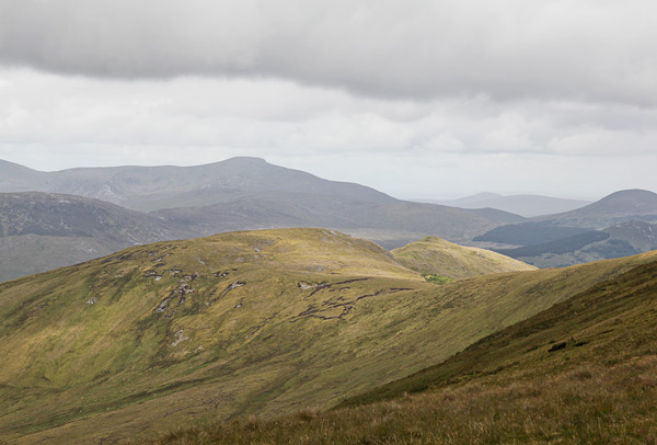
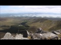
Picture: Mount Eagle from Birreencorragh Sth, Glennamong on skyline.
This is a fairly small summit crowded by the Birreencorraghs to the east and Buckoogh to the south. Nevertheless it has good views to the western Nephin Begs. It can be reached from Buckoogh (keep west of the forestry) or as part of a visit to the Bireencorraghs.
To the NE there is a small hill, not currently included in MV lists lacking the required prominence. The summit has a small cairn.
Mount Eagle is unlikely to be visited as a destination in itself; visitors will most likely be en route to Birreencorragh from the Srahmore River valley or, as in our case, on a traverse between Buckoogh and Birreencorragh. To its south, in the Skerdagh River valley, the widespread afforestation is both an eyesore (due to felling and the irregular shape) and a hindrance to a more desirable direct route from Buckoogh to Birreencorragh. Although 124m lower than its nearest neighbour Birreencorragh West top, it is a much more rewarding summit, with stunning expansive views of the entire Nephin Beg Range (including Slieve Carr), with Clare Island also visible through a gap between peaks. Approaching from Buckoogh, walkers may be tempted to short-cut through the felled area, which is much longer than it appears from the ridge north off Buckoogh. Best to keep west of the forest edge. Walkers may prefer to keep left of the steeper rockier section on the south west approach to Mount Eagle. Linkback: mountainviews.ie/summit/704/comment/6238/
Read Less
Read More
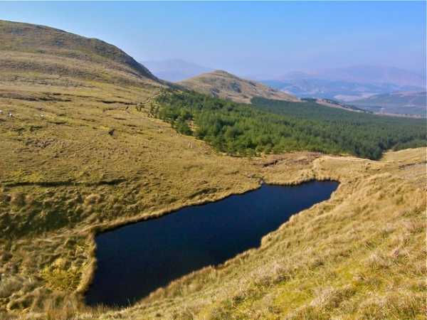
Picture: Eagle valley
In the shadow of the eagle
by Colin Murphy
9 Jun 2011
This small unnamed body of water in the Mount Eagle's shadow, along with the forestry and the small 380m-ish hill in the background, gives the spot quite a picturesque, Alpine feel. Linkback: mountainviews.ie/summit/704/comment/6285/
Read Less
Read More
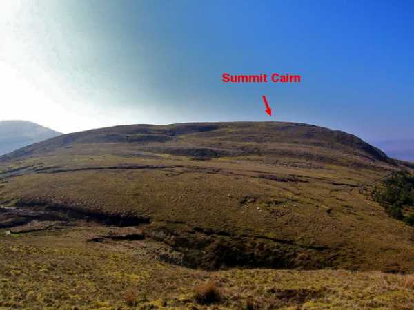
Picture: Summit cairn location
Nice spot for lunch
by Colin Murphy
9 Jun 2011
Pic shows the location of the small cairn on the elongated Mount Eagle, as seen from the approach from Bireencorragh West Top. The top is a mixture of grass and rocks and offers wonderful all round views. Good place for the sambos and tea. Linkback: mountainviews.ie/summit/704/comment/6284/
Use of MountainViews is governed by conditions and a privacy policy.
Read general information about the site. Opinions in material here are not necessarily endorsed by MountainViews.
Hillwalking is a risk sport. Information in comments, walks, shared GPS tracks or about starting places may
not be accurate for example as regards safety or access permission. You are responsible for your safety and your permission to walk.
See the credits and list definitions.


 Our Facebook page.