This website uses cookies, which are small text files that the website puts on your device to facilitate operation. Cookies help us provide a better service to you. They are used to track general user traffic information and to help the website function properly.
Bluestack MountainsArea, SW: Eany Beg Hills
Subarea
Feature count in area: 45, all in Donegal,
OSI/LPS Maps: 11, 6
Highest Place: Croaghgorm 674m
Starting Places (22) in area Bluestack Mountains: An Leathchruach, Barnsmore Gap, Bensons Hill, Caldragh CP, Clogher South peak, Cruach Mhín an Neanta, Doobin, Eanybeg Water Bridge, Edergole Farm, Gaugin Mountain, Glennacree CP, Hillhead, Lough Finn West, Lough Magrath Beg NE, Lough Muck North, Meenaguse Lough, Sand Lough Forest Picnic Area, Scoil Náisúnta an Choimín, Sheskinlubanagh, Sruell Gap Farm, Sruell River Road, St Columbkilles Well and Altar
Summits & other features in area Bluestack Mountains: Cen: Reelan Hills: Altnapaste 364m, Gaugin Mountain 565m, Lacroagh 403m, Boultypatrick 429m, Croveenananta 476m, Croaghubbrid 416m, Croaghugagh 410m N: Fintown Hills: Aghla Mountain South Top 589m, Aghla Mountain 593m, Scraigs 426m, Croaghleheen 385m NW: Glenties: Cloghercor South 301m, Derkbeg Hill 332m, Drumnalough Hill 282m S: Belshade: Croaghgorm 674m, Croaghgorm South-West Top 597m, Croaghgorm East Top 594m, Ardnageer 642m, Ardnageer SW Top 626m, Banagher Hill 392m, Croaghbane 641m, Croaghgorm Far South-West Top 561m, Cronamuck 444m, Croaghbarnes 498.8m, Glascarns Hill 578.3m, Meenanea 435m SE: Barnesmore: Brown's Hill 496.4m, Cloghervaddy 402m, Croaghagranagh 440m, Croaghanirwore 546.1m, Croaghbrack 401m, Croaghconnellagh 523m, Croaghnageer 569.1m, Croaghnageer East Top 543.5m, Croaghnageer North-East Top 521m, Croaghonagh 451m SW: Eany Beg Hills: Binbane 453m, Binbane NE Top 439m, Lavagh Beg 650m, Lavagh More 671m, Binnasruell 505m, Carnaween 521m, Cloghmeen Hill 429m, Silver Hill 600m, Cullaghacro 476m
Note: this list of places may include island features such as summits, but not
islands as such.
Cloghmeen Hill, 429mHill
Place Rating ..
, Donegal County in Ulster province, in Carn Lists, Cloghmeen Hill is the 810th highest place in Ireland.
Grid Reference G85555 87456,
OS 1:50k mapsheet 11 Place visited by: 26members, recently by: gdg, BleckCra, eamonoc, Pepe, pmeldrum, madfrankie, melohara, johncromie, Aidy, hgboyle, markmjcampion, shaunkelly, bramblerjunior, simoburn, Fergalh
I visited this place: NO (You need to be a logged-in member for this.)
Longitude: -8.22502, Latitude: 54.734874, Easting: 185555, Northing: 387456,
Prominence: 71m, Isolation: 1.2km ITM: 585507 887448 Bedrock type: Pale quartzite, pebble beds, rare schist, (Gaugin Quartzite Formation) Notes on name: This peak is in the townland of Disert (par. of Inver) and is unnamed on the 1st edition OS 6” map. Any information on the Irish name of this hill would be welcome.
Short or GPS IDs, 6 char: ClghHl, 10 char: ClghmnHil Linkback: https://mountainviews.ie/summit/693/
Gallery for Cloghmeen Hill and surrounds
Summary
for Cloghmeen Hill :
Gives access to a splendid ridge.
Summary created by Harry Goodman
2013-10-03 23:42:56
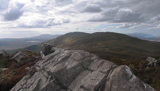
Picture: View across to Cloghmeen Hill from the Bluestack Way
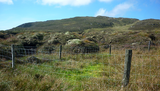
To get to the start take the minor road L1845 off the N56 at A (G924 787) and go NW to Letterbarra and then N to B (G883 869) where a minor road turns of left following the Bluestack Way. Go along it to where the surfaced road becomes a stone and gravel track and park at C (G87071 86956) a short way along. Walk S along the track for some 400 metres and turn up right at D (G86863 86852) following the signed Bluestack Way for 1.5km to gain the ridge at E (G86009 88023). Cross a step stile and turn left along the fence line to a prominent small raised mound and a large yellow topped post F (G85762 87877). Turn left, cross the fence and and head SSW over hummocky ground of peat hags and long grass for about 500 metres to the top. The high point is on a small, but prominent, sharp pointed rocky upcrop. Views are extensive SW past Binbane to the high tops of SW Donegal and back NE along the ridge to the Bluestacks. Distance up and back 5.6km.
The summit is a further bump on the ridge from the aesthetic Binbane to the start of the Bluestacks proper at Carnaween. Looking west along the ridge the two summits of Binn Bhán NE Top (to the right) and Binn Bhán (Binbane) are shown in all their rounded, peat covered glory.
Use of MountainViews is governed by conditions and a privacy policy.
Read general information about the site. Opinions in material here are not necessarily endorsed by MountainViews.
Hillwalking is a risk sport. Information in comments, walks, shared GPS tracks or about starting places may
not be accurate for example as regards safety or access permission. You are responsible for your safety and your permission to walk.
See the credits and list definitions.


 Our Facebook page.