This website uses cookies, which are small text files that the website puts on your device to facilitate operation. Cookies help us provide a better service to you. They are used to track general user traffic information and to help the website function properly.
Feature count in area: 57, by county: Cork: 32, Kerry: 36, of which 11 are in both Cork and Kerry,
OSI/LPS Maps: 83, 84, 85, 88
Highest Place: Hungry Hill 682m
Starting Places (51) in area Caha Mountains: Ardgroom, Barley Lake North, Bere Island Pier, Caha Pass, Canshanavoe South, Carriganine, Cashelkeelty Stone Circles Carpark, Castletownbere Lifeboat Harbour, Clashduff River Farm, Coolieragh Harbour Road, Coomadayallig Lake Road N, Coomadayallig Lake Road S, Cooryeen Lane, Cummer Lough East Road, Derreenataggart Stone Circle Road, Dromoghty Lough North, Dunboy Wood, Esk Boreen, Eyeries, Fehanah Lane, Garinish Island Pier, Glantrasna Bridge, Glenbeg Lough N, Glengarriff, Glengarriff Nature Reserve CP, Gleninchaquin Waterfall, Gowlaun Lough, Healy Pass, Healy Pass Hairpin, Ilnacullin Car Park, Kenmare Bridge, Knockacullin Lane, Leahill Bog, Leitrim Beg Standing Stone, Lough Inchiquin SE, Magannagan Stream, Molly Gallivan's Visitor Centre, Nora's Cottage, Old Lansdowne School, Owgarriff River Lane, Peg's Shop, Pooleen Wood Car Park, Red Trout Lake, Reenroe Bridge, River Drimminboy Track, Rossmackowen Bridge, Rossmackowen Cemetery, Shronebirrane Farm, Shronebirrane Road, Toberbanaha, Turner's Rock Tunnel
Summits & other features in area Caha Mountains: Cen: Hungry Hill: Coombane 510m, Derryclancy 554m, Hungry Hill 682m Cen: Knockowen: Cushnaficulla 594m, Glenkeel Top 417m, Knockastumpa 398m, Knockeirky 577m, Knockeirky South Top 523m, Knockowen 658m, Stookeennalackareha 412m E: Glengarriff: Derrynafulla SW 375m, Gowlbeg Mountain 362m, Nareera 530m, Nareera North Top 503m, Nareera South-West Top 505m, Shrone Hill 283m, Sugarloaf Mountain 574m, Sugarloaf Mountain Far West Top 560m, Sugarloaf Mountain West Top 565m N: Coomnadiha: Baurearagh Mountain 489m, Caha Far SE Top 555m, Caha SE Top 585m, Coomnadiha 644m, Coomnalack Top 435m, Cummeenbaun 510m, Droppa 522m, Killane Mountain 537m, Killane Mountain South-West Top 533m, Knockagarrane 414m, Knockreagh 500m N: Knockeirka: Barraduff Mountain 400m, Killaha Mountain 400m, Knockeirka 426m N: Knocknagorraveela: Derrysallagh 410m, Feorus East 474m, Knocknagorraveela 507m, Knocknagorraveela NE Top 464m N: Lauragh: Knockanoughanish 386m, Knockatee 330m S: Castletownbere: Disert 205m, Knockanallig (Bear Island) 267m W: Ardgroom: Derryvour Hill 160m W: Eskatarriff: Coomacloghane 599m, Eskatarriff 600.5m, Eskatarriff East Top 532.7m, Knocknaveacal North Top 509.1m, Knocknaveacal South Top 507.2m, Lackabane 603m, Tooreenbaha 408.7m, Tooreennamna 524m, Tooth Mountain 592m W: Knocknagree: Knocknagree 586m, Knocknagree East Top 461m, Knocknagree SE Top 442m, Lackawee 572m, Maulin 621m, Maulin North Top 579m
Note: this list of places may include island features such as summits, but not
islands as such.
Coomnalack Top, 435mHill Cnoc Chom na Leac A name in Irish,
Place Rating ..
, Kerry County in Munster province, in Carn Lists, Coomnalack Top is the 789th highest place in Ireland.
Grid Reference V86202 60152,
OS 1:50k mapsheet 85 Place visited by: 41members, recently by: bandre, Superterence, maoris, abcd, Wilderness, mountainmike, chelman7, Taisce, annem, nickywood, Fergalh, daitho9, eamonoc, hivisibility, muddyboots
I visited this place: NO (You need to be a logged-in member for this.)
I approached Coomnalack from Knocknagorraveela, it is a failry straightforward 2.5km trek over mainly boggy terrain
followed by an ascent up easy angled slabs to small summit plateau, the actual top of Coomnalack sits above a tiny unamed lough that appears on OS 85. Coomnalack is situated in a stunning location surrounded by a magnificent amphitheatre of higher mountains and with brilliant views out over Glaninchiquin. I parked at Cummer L (V89621 63552), which gave a round trip of approx12.5km and took me 3hrs. Linkback: mountainviews.ie/summit/671/comment/20912/
Read Less
Read More
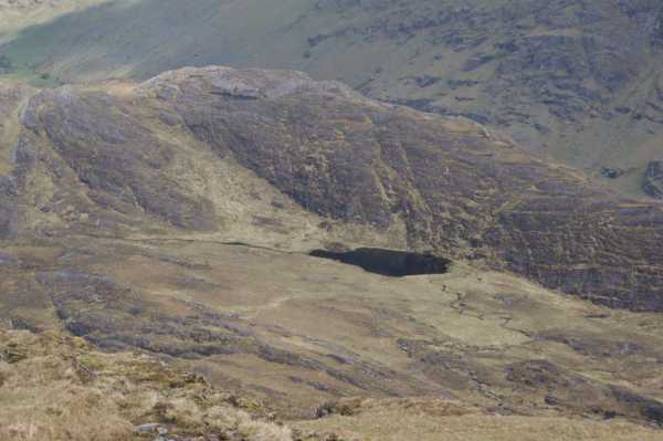
Picture: Coomnalack Top from the slopes of Coomnadiha
Peter Walker on Coomnalack Top
by Peter Walker
23 May 2009
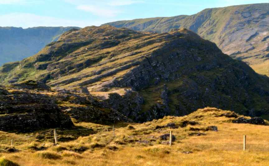
This top squats cheekily next to 'the lake on the saddle' mentioned by Lynam in Best Irish Walks when describing the trip round the head of Gleninchaquin: in the picture included it's seen from the rather slithery descent from Coomnadiha. Personally, I gained it by crossing the lake outflow and trudging up the obvious avenue of grass leading up diagonally left: from the head of this the top is a few clambery minutes away to the right. Those with more time might prefer to gain the skyline to the right of the top (just off the right of the pic), as that ridge looks quite entertaining in profile. This whole area is a tangle of steep grass, knolls and glacially scoured rock, which I'd imagine would be 'interesting' if the cloud was down: on a fine day, it's an excellent and not-that-testing circuit. Linkback: mountainviews.ie/summit/671/comment/3775/
Use of MountainViews is governed by conditions and a privacy policy.
Read general information about the site. Opinions in material here are not necessarily endorsed by MountainViews.
Hillwalking is a risk sport. Information in comments, walks, shared GPS tracks or about starting places may
not be accurate for example as regards safety or access permission. You are responsible for your safety and your permission to walk.
See the credits and list definitions.


 Our Facebook page.