Cookies.
This website uses cookies, which are small text files that the website puts on your device to facilitate operation. Cookies help us provide a better service to you. They are used to track general user traffic information and to help the website function properly.
Features
Nearby features appear when you click the map.
Declutter tracks on map.
Place Search
Video
X
Pub: by
Antrim Hills Area , Cen: Central Antrim Hills Subarea
Feature count in area: 27, all in Antrim, OSI/LPS Maps: 14, 15, 4, 5, 8, 9
Highest Place: Trostan 550m

Starting Places (3) in area Antrim Hills:
Donalds Carn, Rathlin Island Ferry Port, Whitehead Golf Club

Summits & other features in area Antrim Hills:
Cen: Central Antrim Hills: Carncormick 436m, Collin Top 429m, Crockalough 402m, Mid Hill 440m, Skerry Hill 459m, Slieveanorra 508m, Slievenahanaghan 418m, Soarns Hill 403m, Tievebulliagh 402m, Trostan 550m
Central Antrim Hills: Slievenanee 543m
N: North Antrim Hills: Carnanmore 379m, Croaghan 417m, Crockaneel 403m, Cross Slieve 206m, Knocklayd 514m, Lannimore Hill 207m
N: Rathlin Island: Kilpatrick (Rathlin Island) 134m
S: Islandmagee: Donalds Carn 141m, Muldersleigh Hill 131m
S: South Antrim Hills: Agnew's Hill 474m, Big Collin 353m, Black Hill 381m, Carnearny 319m, Douglas Top 402m, Slemish 437.9m
W: West Antrim: Long Mountain 215m

Note: this list of places may include island features such as summits, but not islands as such.
Rating graphic.
Carncormick, 436m Hill Carn Chormaic A name in Irish,
Place Rating ..
(prob. Ir. Carn Chormaic [PDT], 'Cormac’s cairn'), Antrim County in Ulster province, in Carn Lists, Carncormick is the 784th highest place in Ireland.
Grid Reference D16915 14333, OS 1:50k mapsheet 9
Place visited by: 36 members, recently by: trostanite, Colin Murphy, garybuz, Paddym99, Kilcoobin, Andy1287, LorraineG60, MichaelG55, eamonoc, Fergalh, Ulsterpooka, Peter Walker, Wilderness, leader1, Garmin
I visited this place: NO (You need to be a logged-in member for this.)
Longitude: -6.175484, Latitude: 54.962814, Easting: 316915, Northing: 414333, Prominence: 91m,  Isolation: 3.5km, Has trig pillar
ITM: 716838 914318
Bedrock type: Olivine basalt lava, (Upper Basalt Formation)
Notes on name: The triangulation pillar on the summit stands on the remains of a cairn.
  Short or GPS IDs, 6 char: Crn436, 10 char: Crncrmck

Linkback: https://mountainviews.ie/summit/668/
Gallery for Carncormick (Carn Chormaic) and surrounds
Summary for Carncormick (Carn Chormaic): Approach from the south west
Summary created by Colin Murphy 2023-09-14 11:35:20
            MountainViews.ie picture about Carncormick (<em>Carn Chormaic</em>)
Picture: Carncormick seen from SW
There is parking for one car next to gate at A (D15543 13011). Walk back down the road to a sort of crossroads and turn NE up a track. (If there is anyone about you should ask for permission to access this.) Continue up this gently rising track, going through 2 gates, one of which has a rusty ‘Beware of bull’ sign. Continue up the track to its highest point (almost 322m ascent) and then turn NEE across the open hillside. The ground rises very gently for about 1.5km, but is mostly firm underfoot and just short grass or heather. The summit is marked by a trig pill. Allow 1 hour 40 minutes for return journey.
Linkback: mountainviews.ie/summit/668/comment/5427/
Member Comments for Carncormick (Carn Chormaic)
Comment create / edit display placeholder

            MountainViews.ie picture about Carncormick (<em>Carn Chormaic</em>)
Picture: Looking north from Carncormick summit to Slievenanee and Trostan
slemish on Carncormick
by slemish 2 Apr 2009
One of the first times I can remember being impressed by the beauty of the Antrim hills was on a school field trip to the Quolie reservoirs many years ago. I had never been back since so I followed gerrym's route to take in both the reservoirs and the summit of Carncormick. It was another beautiful spring afternoon as I headed up Quolie Lane towards Reservoir 1. There is space to park at the gate without blocking it. The initial stages were easy over sheep-cropped fields. The imaginatively-titled Reservoir 2 soon comes into view. As you ascend the ground becomes more boggy with the odd peat hag although nothing as bad as Trostan or Slievenanee. It must be a mile to the summit at least as this part seems to go on for ages. Care should be taken as the deep heather hides the many small burns which cross the slope. A misplaced foot into one of these can easily result in an ankle sprain or worse so keep your eyes peeled. Eventually you reach the trig pillar on the summit at 436m. The flush bracket and spider in particular were in very good condition. Today was fine and very warm for early April but quite hazy. This meant there was no chance of the longer views to the Sperrins and Scotland. However there were still fine views to be had: east to Mid Hill and the gaping Glenariff, south over the Braid valley to Slemish and Agnew's Hill and north to Glenravel with the village of Cargan hugging the slopes of Slievenanee with Trostan and Slieveanorra to either side. I completed the walk by descending to the south back to Quolie Lane. Took longer than I expected but a beautiful and peaceful walk. Total trip about 2 hrs. Linkback: mountainviews.ie/summit/668/comment/3695/
Read Less
Read More

            MountainViews.ie picture about Carncormick (<em>Carn Chormaic</em>)
Picture: looking to the bigger antrim hills to the N
gerrym on Carncormick
by gerrym 8 Sep 2007
This walk starts from the SE side of the hill. Take the road to the Quolie resevoirs, using the parking space for several cars before the gate (B (D174 114)). Follow the track alongside the Quolie river, firstly with pasture hemmed in by stone walls containing cows, sheep and horses as company, but then further into the rough moorland of the surrounding hills. The water of the river is brown from the peat covered hills and soon glimpse the bank of grass holding back a great volume of it at Quolie resevoir 1. Cross the grass bank and a bridge over the water outlet, which cascades down a glittering stairway. A raised trackway follows the river on one side and the resevoir on the other, I wore my temporary shepard hat here as a group of sheep hurried along in front with no escape.
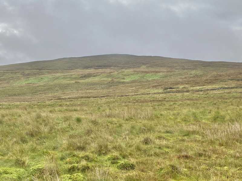
Occasionally fish would perform ballet in the air above the waters of the resevoir as i walked. An iron girder provides a crossing point over the river onto the hillside, as climb the second higher resevoir comes into view. A few fish jumping here would have been welcome to reduce the cleg popualtion which had great joy in biting through my light fleece. The ground is good for a while but soon turns to deep tussocky heather where every footstep is an accident waiting to happen - this goes on for ages as walk NW before reaching the sensibler ground at the trig pillar.
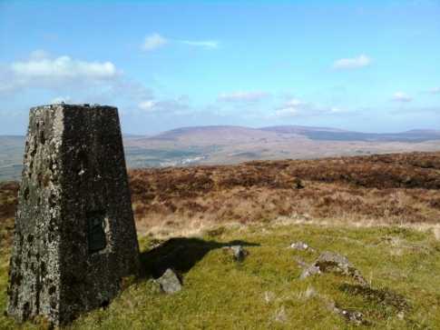
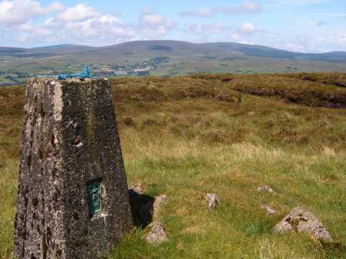
It was a good day and the views were similar, all the bigger hills to the N (Trostan, Slivenanee etc), the Sperrins from the N coast down and most impressively into the gaping valley of Glenariff which had a swathe of low cloud reaching up to its brim. Absolutely beautiful views in all directions as puffy cumulus dotted a blue sky. Butterflies and bees kept me company as i sat and drank in the views and my lunch.
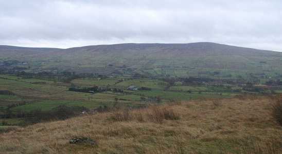
Continued on to Mid Hill following the fenceline and returned back down to Quolie resevoir 2, following the track easily back to where i had parked. I think there is no doubt that it does pay to explore the lower hills - new experinences and challenges are an important part of walking as well as going back to the trusted and well worn paths of the likes of the Mournes. Linkback: mountainviews.ie/summit/668/comment/2816/
Read Less
Read More

            MountainViews.ie picture about Carncormick (<em>Carn Chormaic</em>)
NICKY on Carncormick
by NICKY 16 Apr 2009
Carncormick is a hill only to be appreciated in good weather. The views can be anywhere between great and awful depending on the weather. By this I mean on a sunny day it is worth it and even on a dull day with a high cloud base the view can be colourless and dull. The best route is to start from Martinstown on the A43 and take the minor road which leads you to a junction between Islandnabracky and Knocknagully.Take a right then a quick left and follow this to the very end. This leads to a country track that will take you to Carncormick's South-Western slopes. When the track splits in two take the left and then just pick your way up the slopes to the cairn. When you arrive you will understand my earlier comments about the views. On this walk you could also include Mid Hill and Collin Top. Simply just follow the North-East ridge through the Red Sea. To complete the route (sorry about the road walking) head for the track on the Northern side of Dungonnell Dam and take left. This is a now a pleasant stroll downhill past Craignamaddy and Cargan Rock. (do these also if you have the time) When you come to the junction near Ballsallagh Bridge take right, then a left at the main road to take you back to Martinstown and your car. A great route which can very peaceful! Linkback: mountainviews.ie/summit/668/comment/2737/
Read Less
Read More

three5four0 on Carncormick
by three5four0 7 Nov 2008
We followed Nicky's excellent route description for the ascent of Carncormick on a cold and clear day in the week past. There was still some small patches of snow, from the snowfall several days previous around the summit trig point, and as we crossed the fence to reach the summit the views opened up towards Scotland. The mountains of Arran were poking over the Mull of Kintyre framed by the jaws of Glenariff, with possibly the Argyll hills slightly to the left showing through as well.

With a day like this, it would have been rude not to continue on the suggested circuit, so go to Mid Hill for the continuation of the route Linkback: mountainviews.ie/summit/668/comment/3430/
Read Less
Read More
EDIT Point of Interest
text
Videos


Recent Contributions
x
Conditions and Info
Use of MountainViews is governed by conditions and a privacy policy.
Read general information about the site.
Opinions in material here are not necessarily endorsed by MountainViews.
Hillwalking is a risk sport. Information in comments, walks, shared GPS tracks or about starting places may not be accurate for example as regards safety or access permission. You are responsible for your safety and your permission to walk.
See the credits and list definitions.

OSi logo
OSNI/LPS logo
Open Street Map
(Various variations used.)
British summit data courtesy:
Database of British & Irish Hills