This website uses cookies, which are small text files that the website puts on your device to facilitate operation. Cookies help us provide a better service to you. They are used to track general user traffic information and to help the website function properly.
Sperrin MountainsArea, NE Cen: Glenelly North East
Subarea
Feature count in area: 64, by county: Derry: 34, Tyrone: 39, of which 9 are in both Derry and Tyrone,
OSI/LPS Maps: 12, 13, 6, 7, 8
Highest Place: Sawel 678m
Starting Places (21) in area Sperrin Mountains: Altinure Road, Banagher Glen Nature Reserve, Barnes Gap Car Park, Crocknakin, Drumnaspar Picnic CP, Glenchiel Road, Glenedra Bridge, Glenelly Road, Parkreagh, Goles Road, Lough Ouske, Moneyneany Village, Moydamlaght Forest, Moydamlaght Road, Mullaghmore, Mullaghbane, Spaltindoagh, Sperrin Hamlet, Sperrin Heritage Centre, Sperrin Heritage Centre W, Sperrin Road, Barnes Top, Sperrin Road, Glashagh Bridge, Sperrin Road, Sperrin
Summits & other features in area Sperrin Mountains: E: Magherafelt Hills: Slieve Gallion NE Top 493.6m E: Magherafelt Hills: Slieve Gallion 526.6m N: Claudy Hills: Crockdooish 321m, Curradrolan Hill 270m, Eglish 277m, Letterlogher 249m, Mullaghmeash Hill 244m, Slieveboy 259m, Straid Hill 303m NE Cen: Glenelly North East: Barnes Top 456m, Craigagh Hill 460m, Crockbrack 526.1m, Knockanbane Mountain 441m, Meenard Mountain 620m, Meenard Mtn W Top 480m, Mullaghaneany 627m, Mullaghash 480m, Mullaghsallagh 485m, Oughtmore 569m, Spelhoagh 568m NE: Glenshane North: Benbradagh 465m, Boviel Top 454m, Carn Hill 448m, Carntogher 464m, Moneyoran Hill 414m NE: Glenshane South: Bohilbreaga 478m, Coolnasillagh Mountain 423m, Corick Mountain 430m, Crockalougha 407m, Mullaghmore 550m, White Mountain 537m NW Cen: Glenelly North West: Dart Mountain 619m, Dart Mountain North-West Top 525m, Learmount Mountain 489m, Learmount Mountain South Top 492m, Mullaghasturrakeen 581m, Mullaghcarbatagh 517m, Mullaghclogha 635m, Mullaghclogher 572m, Mullaghdoo 568m, Sawel 678m NW: Maheramason Hills: Clondermot Hill 220m, Gortmonly Hill 218m, Slievekirk 370m SE Cen: Glenelly South East: Carnanelly 562m, Carnanelly West Top 503.4m, Mullaghbane 467m, Mullaghturk 416m SE: Cookstown Hills: Cregganconroe 300m, Fir Mountain 362m, Oughtmore 382m SW Cen: Glenelly South West: Clogherny Top 408m, Craignamaddy 385m, Crocknamoghil 335m, Mullaghbolig 442m, Spaltindoagh 420m SW: Mullaghcarn: Curraghchosaly Mountain 416m, Mullaghcarn 542m, Mullaghcarn South Top 525m SW: Newtownstewart Hills: Bessy Bell 420m, Mullaghcroy 242m W: Strabane: Balix Hill 403m, Knockavoe 296m, Owenreagh Hill 400m
Note: this list of places may include island features such as summits, but not
islands as such.
Knockanbane Mountain, 441mHill Cnocan Bán A name in Irish,
Place Rating ..
(Ir. Cnocan Bán [OSNB], 'white hillock'), Derry County in Ulster province, in no lists, Knockanbane Mountain is the 767th highest place in Ireland.
Grid Reference C63094 00203,
OS 1:50k mapsheet 7 Place visited by: 30members, recently by: garybuz, Paddym99, Lucky1, Kilcoobin, dregish, Hoverla, trostanite, wicklore, eamonoc, Aidy, Fergalh, LorraineG60, MichaelG55, Wilderness, Ulsterpooka
I visited this place: NO (You need to be a logged-in member for this.)
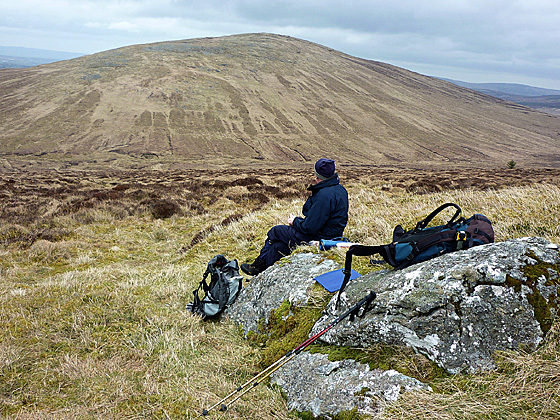
Picture: Mullaghash from the N slope of Knockanbane Mt
Harry Goodman on Knockanbane Mountain
by Harry Goodman
3 Apr 2010
We climbed Knockanbane Mountain on 23 March 2010 as part of a round of hills which also included Mullaghash and Barnes Top (see my comments on both of these hills for the first two stages of the route.) We approached Knockanbane Mt. by following a fence for 800 metres along the broad ridge that runs NW from Barnes Top. The summit lies approximately 70 metres SW of the fence on the flat boggy top at A (H631 002) and not at B (H651 002) as shown on the mountain views grid reference. This reference relates to a point some 2k to the E of Knockanbane Mt. All along the ridge there are splendid views S to the High Sperrins Ridge with Sawel prominent just across the valley. From the top we headed N with a slight touch of W to cross a fence and then went down the hillside to cross a stream at C (H62936 01375) before climbing steeply up the bank to a rough stone and muddy track. A left turn along the track brought us to a wooden gate which we passed through and then, further along, to two more metal gates. Further down we passed over a stone/cement bridge just before the wooden bridge that we had taken on our route to Mullaghash earlier in the day. From there it was a short walk out to the road and the starting point at D (C62398 02490). Before going for this walk I had read Derry259's comments but declined to also include Sawel and Dart on our route! However one point of interest occurs. The hill after Mullaghash in Derry259's comments should read Barnes Top and not Knockanbane Mt as shown. Knockanbane Mt lies to the W of Barnes Top not the other way round. I suspect Derry259 and Old Brendan must have been celebrating St Patrick's Day with a touch or more of the hard stuff and got their hills mixed up !! Linkback: mountainviews.ie/summit/651/comment/4558/
Read Less
Read More
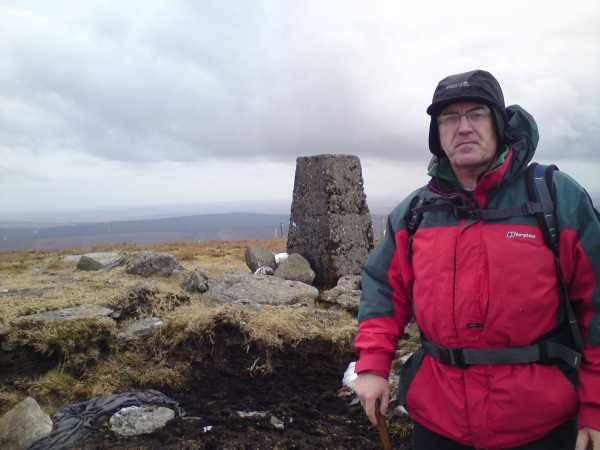
Picture: Highest man in Derry ......
Derry259 on Knockanbane Mountain
by Derry259
22 Mar 2010
On St Patricks Day myself and old Brendan climbed Knockanbane as part of a walk which took in Mullaghash,Barnes Top, Sawel and Dart. We parked at the old pub on the b44 between Feeny and Park and followed the lane signposted Ballydonegan Sweat House.Following this lane for approx a mile as it passes through a farm yard past a wooden bridge, through two gates and across a stream we reached the base of Mullaghash whos stoney summit could be seen of to the left.We reached Mullaghashs summit which is marked by large rock and turned right at the fence and followed it down and then up onto Barnes Top ,the fence turns right again and runs into a dip before rising to Knockanbanes summit.(Knockanbane and Barnes Top are basicaly two bumps on one mountain) We descended Barnes Top and reached Barnes Road at this point Brendan informed me that the farmer who owns this mountain is a bit funny about access.After crossing the road we forded the stream at the bottom of the valley before starting a steady ascent of Sawel,stopping for tea half way up.With our batteries recharged we set of again,old Brendan like a hare and me a tortoise.(must be the DELICIOUS chocolate which gives him a boost) We topped Sawel and headed into the valley between it and Dart .A quick ascent of Dart finished our climbing for the day and left us with a long two hour walk back to the car(including a 3.5 mile road walk)From Darts summit head for Crockahilly road which is in roughly a Northern direction ,at end of this road take right onto Dreen road ,then take the first left onto Kilcreen road ,follow this to its end and turn right at the b44 and 10 minutes walk away is the start point.....A good walk which took 6.5 hours including stops for tea and various pics Linkback: mountainviews.ie/summit/651/comment/4526/
Use of MountainViews is governed by conditions and a privacy policy.
Read general information about the site. Opinions in material here are not necessarily endorsed by MountainViews.
Hillwalking is a risk sport. Information in comments, walks, shared GPS tracks or about starting places may
not be accurate for example as regards safety or access permission. You are responsible for your safety and your permission to walk.
See the credits and list definitions.


 Our Facebook page.