Cookies.
This website uses cookies, which are small text files that the website puts on your device to facilitate operation. Cookies help us provide a better service to you. They are used to track general user traffic information and to help the website function properly.
Features
Nearby features appear when you click the map.
Declutter tracks on map.
Place Search
Video
X
Pub: by
Donegal Central Area , SW: Glendowan Mountains Subarea
Feature count in area: 15, all in Donegal, OSI/LPS Maps: 1, 2, 6
Highest Place: Moylenanav 539m

Starting Places (28) in area Donegal Central:
Astelleen Burn Waterfall, Ballyarr, Binnadoo, Braughan Road, Drumfin Bridge, Edenacarnan East, Edenacarnan North, Edenacarnan South, Garrangalta Rocks, Gartan Wood, Glenveagh Bridge, Glenveagh National Park SW, Glenveigh Castle, Losset North, Lough Acrobane Farmhouse, Lough Acrobane South, Lough Acrobane South West, Lough Barra Slipway CP, Lough Barra W, Lough Natooey West, Lough Salt North, Lough Salt West, Moyle Hill, Nabrackbaddy Lough, Parochial House, River Barra Bridge NE, River Barra Bridge SW, Sruhancrolee Bridge

Summits & other features in area Donegal Central:
NE: Loughsalt Hills: Crockmore 349m, Croaghmore 278m, Edenacarnan 192m, Loughaskerry 252m, Loughsalt Mountain 469m, Moyle Hill 148m, Stragraddy Mountain 285m
SW: Glendowan Mountains: Binswilly 337m, Brown Mountain 224m, Cionn Bheatha 384m, Crockastoller 418m, Farscallop 420.6m, Gartan Mountain 357m, Leahanmore 442m, Moylenanav 539m

Note: this list of places may include island features such as summits, but not islands as such.
Rating graphic.
Leahanmore, 442m Hill An Liathán Mór A name in Irish,
Place Rating ..
(prob. Ir. An Liathán Mór [PDT], 'big grey one '), Donegal County in Ulster province, in Carn, Irish Best Hundred Lists, Leahanmore is the third highest hill in the Donegal Central area and the 760th highest in Ireland.
Grid Reference C01797 16618, OS 1:50k mapsheet 6
Place visited by: 26 members, recently by: Colin Murphy, Wilderness, eamonoc, markmjcampion, cody1, finkey86, Fergalh, IainT, madfrankie, melohara, Ulsterpooka, kmoore, 40Shades, chalky, kenmoore
I visited this place: NO (You need to be a logged-in member for this.)
Longitude: -7.97271, Latitude: 54.997023, Easting: 201797, Northing: 416618, Prominence: 257m,  Isolation: 1.9km
ITM: 601746 916603
Bedrock type: Coarse biotite granite & granodiorite, (Main Donegal Granite)
Notes on name: Leahanmore is in the Glenveagh National Park and is the highest point in the group of hills between Lough Beagh and Gartan Lough.
  Short or GPS IDs, 6 char: Lhnmr, 10 char: Leahanmore

Linkback: https://mountainviews.ie/summit/645/
Gallery for Leahanmore (An Liathán Mór) and surrounds
No summary yet for this place .
Member Comments for Leahanmore (An Liathán Mór)
Comment create / edit display placeholder

            MountainViews.ie picture about Leahanmore (<em>An Liathán Mór</em>)
Picture: Looking over Farscallop towards Muckish from summit of An Liathan Mór
eflanaga on Leahanmore
by eflanaga 30 Apr 2008
Climbed as part of circuit starting at Glendowan Beg and including Crockscallabagh, Moylenav, Meenabog Hill & Farscallop. Dropped steeply off Farscallop's eastern aspect into Glentack Burn's narrow valley before steady ascent up grassy slopes before final climb over rockier terrain to reach summit area in fading sunlight. As ever views are extensive and breathtaking. Descended via Meenaneagh Burn crossing Bullaba River at shallow point near Glendowan Bridge to reach car. Total circuit took around 6.5 hours - thoroughly enjoyable demonstrating that even the smaller hills can provide a worthwhile day's walking. Linkback: mountainviews.ie/summit/645/comment/3073/
Read Less
Read More

            MountainViews.ie picture about Leahanmore (<em>An Liathán Mór</em>)
Picture: From the West.
Photo from the west.
by simon3 1 Nov 2012
A photo of the summit taken from Farscallop. Linkback: mountainviews.ie/summit/645/comment/14852/
Read Less
Read More

            MountainViews.ie picture about Leahanmore (<em>An Liathán Mór</em>)
Picture: View W from An Liathan Mor to Moylenanav centre and Slieve Snaght top right
A worthwhile climb
by Harry Goodman 20 May 2010
Climbed An Liathin Mor on 3 May 2010 as the third and final day of walking in the Derryveagh/Glendowan Mountains. We took the shuttle bus from the Glenveigh National Park Visitor Centre to the Castle and then walked SW out the lakeside track along Lough Beagh to A (C00300 18800) where we turned steeply up left on a good track leading into Glenlack. The track soon began to level out and even undulated a little up and down. Eventually the track disappeared as we continued on up towards the head of the Glen to B (C00272 17123). Because of the dry weather in recent weeks the going was fairly good but I understand it can be very marshy indeed after a period of rain. From here we headed SE up around the spur of Kinnaveagh to a flat area 
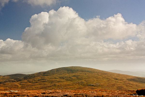
C (C00771 16775) below the W slope of An Liathan More. From here it was a steady climb up to the summit cairn 
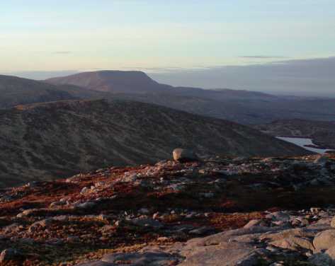
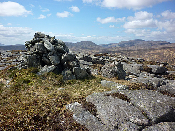
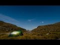
D (C01783 16630). The views from the top were far reaching SSW to the Bluestacks N to Inishowen and E to the Sperrins. There was also a fine view SW over the Glendowan Mountains and Slieve Snaght (see photo). The top of this hill ia an excellent vantage point to sit and savour the beauties of NW Donegal. On this occasion we returned by our outward route. However I would also commend a circular route which takes in Kinnavagh and Altachoastia the small ridge of hills along the E side of Lough Beagh. To follow this route go back down from the summit to the coll C (C00771 16775) and then head N for Pt 343 E (C00800 17300) on the southern spur of Kinnaveagh before climbing NNE along the ridge to the top F (C01425 18500). There are fine views from this high point on the ridge down NE over Lough Nambraddan and Lough Inshagh. Continue N over Pt 268 G (C01500 19300) and then down NE to a coll before the short climb up to Altachoastia H (C02400 20225). From here a walk down the ridge NE for 1.4k leads to the Gartan Track I (C03000 21500). Turn left and after some 200m meet the main access road from the Visitor Centre, turn left and follow along for some 700m to the Castle approx and the Shuttle Bus. A rewarding circuit out to An Liathin Mor.

slieve Snaght (see photo) Linkback: mountainviews.ie/summit/645/comment/4749/
Read Less
Read More

A wild rough beastie!
by IainT 1 Oct 2018
If you just want to do Leahanmore on its own then park at J (C015 135) (lots of space). Walk about 400m up the road westwards and a rough track goes right to a bridge over the river. There is a gate through the deer fence just beyond, then open tussockland leads up over Leahanbeg to the main summit. Higher up rocky slabs provide a bit of easier going, and low down the remains of an ATV track up the west flank of the valley give a bit of help, but most of it is just plain rough. The view northwards to the main Derryveagh range is excellent. Linkback: mountainviews.ie/summit/645/comment/20076/
Read Less
Read More
EDIT Point of Interest
text
Videos


Recent Contributions
x
Conditions and Info
Use of MountainViews is governed by conditions and a privacy policy.
Read general information about the site.
Opinions in material here are not necessarily endorsed by MountainViews.
Hillwalking is a risk sport. Information in comments, walks, shared GPS tracks or about starting places may not be accurate for example as regards safety or access permission. You are responsible for your safety and your permission to walk.
See the credits and list definitions.

OSi logo
OSNI/LPS logo
Open Street Map
(Various variations used.)
British summit data courtesy:
Database of British & Irish Hills