This website uses cookies, which are small text files that the website puts on your device to facilitate operation. Cookies help us provide a better service to you. They are used to track general user traffic information and to help the website function properly.
Feature count in area: 62, by county: Cork: 45, Kerry: 24, of which 7 are in both Cork and Kerry,
OSI/LPS Maps: 78, 79, 85, 86, 88, 89
Highest Place: Knockboy 704.8m
Starting Places (47) in area West Cork Mountains: Barley Lake North, Barrboy, Caha Pass, Carranmore, Carrigacappeen, Carriganass Castle, Castle Donovan Car Park, Clearagh House, Coolkellure House, Coomhola Bridge, Corrigatirra, Cousane Gap, Cummer Lough East Road, Derreencollig Wood, Esk Boreen, Fuhiry Wood, Garinish Island Pier, Glasagarav River Bridge, Glasnacummeen Stream, Glengarriff, Glengarriff Nature Reserve CP, Gorteeniher Drimoleague Heritage Walk CP, Gortloughra River Road, Gougane Barra Oratory, Gougane Barra Park CP, Grousemount Wind Farm, Kealkill Village, Knockanuha, Knockbrack South, Lough Atooreen N, Lough Nambrackderg North, Lough Nambrackderg Wood, Lough Nambreacdearg, Mealagh Bridge, Molly Gallivan's Visitor Centre, Nowen Hill West Road, Owvane River Bridge, Pookeen North Top Road, Pooleen Wood Car Park, Priests Leap, Reenroe Bridge, River Roughty, Shandrum Concrete Silo, Sillahertane Stream, Slaheny River Horseshoe, Top of Coom, Turner's Rock Tunnel
Summits & other features in area West Cork Mountains: Cen: Maughanaclea: Maughanaclea Hills East Top 470m, Maughanaclea Hills West Top 452m Cen: Shehy More: Shehy More 545.6m, Shehy More SW Top 446m E: Clearagh: Clearagh Hill 287m E: Currane: Currane Hill 228m N Cen: Douce: Douce Mountain 476m, Doughill Mountain 471m N: Carran: Barnastooka 497m, Bealick 537m, Carran 604m, Carran Far NE Top 561m, Carran Far North Top 506m, Carran NE Top 555m, Carran South Top 567m, Knockantooreen 450m N: Conigar: Conigar 566m, Conigar SW Top 566m, Foilastookeen 540m N: Coomataggart: Carrigalougha 423m, Coomataggart 530m, Coomataggart SW Top 509m, Derrineanig 304m, Lackabaun 472m, Mweelin 487m NE Cen: Carrigarierk: Carrigarierk 343m NW: Barraboy: Barraboy Mountain 460m, Barraboy Mountain Far East Top 456m, Barraboy Mountain SE Top 409m, Derroograne 468m, Turners Rock 420m NW: Knockboy: Caoinkeen 692.8m, Caoinkeen South-East Top 553.5m, Coomhola Mountain 472m, Knockboy 704.8m, Knockboy North Top 651.2m, Knockboy South Top 533.3m, The Priest's Leap 519m NW: Knocknamanagh: Bird Hill 412m, Coomclogherane Top 449m, Gullaba Hill 603m, Knockbrack 440m, Knockbrack South Top 458m, Knocknamanagh 637m, Knocknamanagh NE Top 625m S Cen: Dunmanway Hills: Cashloura 296.8m, Coolsnaghtig 295.8m, Inchanadreen 310m S Cen: Nowen: Milane Hill 354.4m, Mullaghmesha 494.3m, Nowen Hill 535.2m, Nowen Hill Far West Top 405.2m, Nowen Hill SW Top 509m, Pookeen North Top 319m S: Leap Hills: Carrigfadda 311.7m, Killeigh Hill 229m, Knockarudane Hill 169m, Knockscagh 195m S: Skibbereen: Barryroe Hill 156m, Lick Hill 158m W Cen: Knockbreteen: Knockbreteen 239m W: Bantry: Knocknaveagh 282m
Note: this list of places may include island features such as summits, but not
islands as such.
Barraboy Mountain, 460mHill Cnoc Bharr Buí A name in Irish,
Place Rating ..
(Ir. Cnoc Bharr Buí [OSI], 'hill of Barr Buí or yellow top'), Kerry County in Munster province, in Carn Lists, Barraboy Mountain is the 692nd highest place in Ireland. Barraboy Mountain is the second most westerly summit in the West Cork Mountains area.
Grid Reference V93816 60843,
OS 1:50k mapsheet 85 Place visited by: 38members, recently by: maoris, Superterence, Colin Murphy, madfrankie, eamonoc, annem, chelman7, Oscar-mckinney, Jai-mckinney, Carolyn105, tfm9, Fergalh, GerSomers, daitho9, Aongus
I visited this place: NO (You need to be a logged-in member for this.)
Summary created by Colin Murphy, thomas_g
2023-10-31 15:16:54
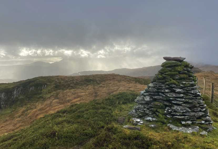
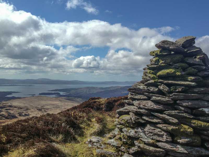
Picture: Summit cairn
Barraboy is best reached from the col between Esk and Barraboy which can be reached from the Beara way. There is parking to be found at A (V91693 59415) almost opposite The Ewe Experience (or next to the building itself) on the N71 to the south. Walk 100m east to the Beara Way track at B (V91922 59372) and turn north, follow it it for 2km up to the col between Esk and Barraboy, next to a transmitter of some sort at C (V92620 60624), turn east and follow the ridge up a mostly grassy slope for about 1.3km (there is a narrow track some of the way) to reach the summit, which is marked by a large cairn.
An alternative is via the N71 to the west of Turner's Rock, where there is parking for a couple of cars. Climb turner's rock and then follow a way marked trail to the col mentioned above.
Views are very good south to the sea and North towards Barraduff. Knockboy is clearly visible to the East.
Parked at Esk Boreen (V93218 61229) (barely room for one car) beside Beara Way stile. Over the stile and up the track, I left the track and went straight for the peak, but it's probably best to follow the track to the col and walk along the ridge enjoying the views down to the bay. The peak is marked by a large cairn. Linkback: mountainviews.ie/summit/579/comment/14982/
Use of MountainViews is governed by conditions and a privacy policy.
Read general information about the site. Opinions in material here are not necessarily endorsed by MountainViews.
Hillwalking is a risk sport. Information in comments, walks, shared GPS tracks or about starting places may
not be accurate for example as regards safety or access permission. You are responsible for your safety and your permission to walk.
See the credits and list definitions.


 Our Facebook page.