Cookies.
This website uses cookies, which are small text files that the website puts on your device to facilitate operation. Cookies help us provide a better service to you. They are used to track general user traffic information and to help the website function properly.
Features
Nearby features appear when you click the map.
Declutter tracks on map.
Place Search
Video
X
Pub: by
Achill & Corraun Area , SW: Clare Island Subarea
Feature count in area: 16, all in Mayo, OSI/LPS Maps: 22, 30, CBW, EW-ACC, EW-ACC
Highest Place: Croaghaun 688m

Starting Places (16) in area Achill & Corraun:
Achillbeg Island, Achillbeg Mid West Beach, Barneygappul Strand, Belfarsad Bridge, Breanaskill, Bunanioo Church, Cartron River, Clare Island, Doogort Beach, Fiodián na Circe, Keem Bay, Lough Acorrymore, Lough Gall, Minaun Mast, Rossnafinna Island, Tobercolman Cross Cemetery

Summits & other features in area Achill & Corraun:
Cen: Minaun: Minaun (Achill Island) 466m
N: Slievemore: Krinnuck (Achill Island) 214m, Slievemore (Achill Island) 671m
NW: Croaghaun: Benmore (Achill Island) 332m, Cornaclea Hill (Achill Island) 269m, Croaghaun (Achill Island) 688m, Croaghaun SW Top (Achill Island) 664m
S: Knockmore Achill: Achillbeg Island N Top (Achillbeg Island) 109.7m, Achillbeg Island S Top (Achillbeg Island) 108.5m, Knockmore (Achill Island) 337m, Tievereivagh (Achill Island) 286m
SE: Corraun: Knocklettragh 452m, Corraun Hill 524m, Corraun Hill Highpoint 541m
SW: Clare Island: Knockmore (Clare Island) 462m, Knocknaveen (Clare Island) 223m

Note: this list of places may include island features such as summits, but not islands as such.
Rating graphic.
Knockmore, 462m Hill An Cnoc Mór A name in Irish,
Place Rating ..
(prob. Ir. An Cnoc Mór [PDT], 'the great hill') Croaghmore an extra name in English, Croaghmore, The Big Hill, Mayo County in Connacht province, in Carn, Irish Islands Lists, Knockmore is the 687th highest place in Ireland. Knockmore is the second most southerly summit in the Achill & Corraun area.
Reachable "On Foot " Y
Grid Reference L66929 86178, OS 1:50k mapsheet 30
Place visited by: 83 members, recently by: srr45, Wilderness, eamonoc, Dee68, poopoobasto, ryanguinness10, Tifred, mgkelly, Fergalh, mdoc1969, hak493r, justynagru, jlk, osullivanm, simon3 , Island visited by 115 members.
I visited this place: NO (You need to be a logged-in member for this.)
, I visited this island: NO
Longitude: -10.020801, Latitude: 53.808217, Easting: 66929, Northing: 286178, Prominence: 462m,  Isolation: 3km, Has trig pillar
ITM: 466908 786192
Bedrock type: Laminated red & green siltstone, (Bunnamohaun Siltstone Formation)
Notes on name: Knockmore is the highest peak on Clare Island. Of all the Irish islands, only Achill has higher mountains than Clare. Walks: for a route taking in Bengorm, Corranabinnia and Glennamong, see Whilde & Simms, New Irish Walk Guide - West and North, 74-75. According to this source, the hill is also known as Croaghmore.
  Short or GPS IDs, 6 char: Knc463, 10 char: Knockmo462

Linkback: https://mountainviews.ie/summit/571/
Gallery for Knockmore (An Cnoc Mór) and surrounds
Summary for Knockmore (An Cnoc Mór): Clare Island High Point
Summary created by Djouce 2013-09-12 21:00:45
            MountainViews.ie picture about Knockmore (<em>An Cnoc Mór</em>)
Knockmore has great views over Clew Bay. In many ways it is similar to its larger cousin, Slievemore, on Achill Island. There are sea cliffs on the northern slopes, which make it dangerous to climb in poor visibility. It can be approached over open country from the east ( a track leading from the road behind the post office) or west (from the signal tower). The ascent is steep over grassy (sometimes boggy) slopes. There is a large cairn just to the west of the trig point at the summit. It takes about an hour to climb from the west.
Linkback: mountainviews.ie/summit/571/comment/5330/
Member Comments for Knockmore (An Cnoc Mór)
Comment create / edit display placeholder

            MountainViews.ie picture about Knockmore (<em>An Cnoc Mór</em>)
Picture: Clare Island is glorious
Wonderful island to spend a day or two exploring
by Damian120 6 Jan 2018
Like Inishturk Island, ferries depart from Roonagh Pier near Louisburgh County Mayo. Bring a picnic and hop on the early morning ferry (15 euro round trip) from Roonagh Pier and enjoy a day exploring this scenic island through any of the several walking trails sign posted on the island

National Geographic nominated Clare Island in the Top 10 Activities along the Wild Atlantic Way

Grace O Malley – The Pirate Queen: This castle is a fine example of a Tower House, built by the O’Malley's in the sixteenth century. Grace O’Malley or Gráinne Uaile who headed the fleet of pirates who reigned supreme in the Clew Bay area at that time. The tower house is located on the left of the pier as you disembark from the ferry.

Cistercian Abbey: It's about a 15-minute walk from the pier – keeping left of the pier and walking towards O'Malley's food store. The Abbey is said to date from the 12th Century, though it was rebuilt around 1460 and is widely known for its elaborately detailed with carved figureheads. Additionally, it houses an O’Malley crest and is rumoured to be the burial site of Grace O’ Malley(Granuaile). It also contains a remarkable series of medieval wall and ceiling paintings. (Please note here is a small sign asking for “No Flash Photography”.) The paintings which once covered the entire ceiling in a kaleidoscope of colour, depict mythical, human & animal figures including dragons, a cockerel, stags, men on foot and on horseback, a harper, birds & trees. Only four other such paintwork examples still exist in Ireland & Clare Island’s is the most intriguing and maybe the best preserved. Also within the abbey is a fine stone plaque of the O'Malley coat of arms and a canopied tomb reputed to be the resting place of Granuaile O'Malley the famous lady sea pirate.

Another of the Napoleonic Towers is located at the western point of Clare Island, at Tuar Mor. Constructed in 1804, as an answer to the impending threat of a Napoleonic invasion during the Napoleonic Wars of 1803 to 1815. The Clare Island tower forms part of a whole network of towers along the coast of Ireland. These towers were central to the early 19th-century communication and alert system.

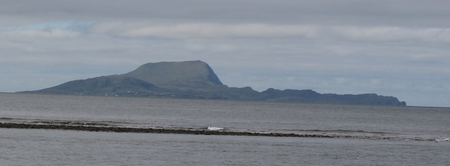
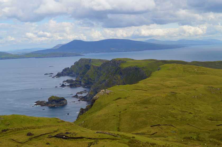
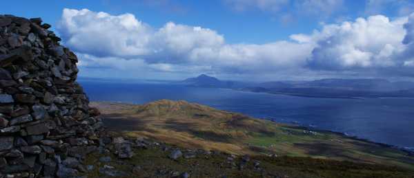
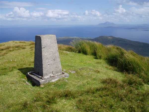
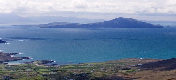
Knockmore Mountain: The mountain is the highest peak on Clare Island. It is a popular walking destination for island residents and tourists and is known for its view of Clew Bay and the west coast mainland as well as a view of the Atlantic Ocean. It's an easier climb approaching from either side but does get very windy at the summit even on the finest of days.

Clare Island lighthouse. It's an uphill trek to the site but the views on display here are some of the best on show anywhere in Ireland. Walk to the right of the lighthouse and witness Achill Island, Croagh Patrick and the north Connemara mountains in one sweeping vista. Linkback: mountainviews.ie/summit/571/comment/19832/
Read Less
Read More

            MountainViews.ie picture about Knockmore (<em>An Cnoc Mór</em>)
Picture: View south from summit cairn
My sweetheart of Clare
by gerrym 10 May 2012
There is nothing like a boat ride to get the senses fired up and adding to the adventure in climbing a mountain. Cue Roonagh Point and a short but spectacular ferry crossing to Clare Island.

Knockmore flaunts herself from every angle on the surrounding shores but was now playing shy and hiding behind the other significant hill on the island (Knocknaveen 223m). This changed gradually on a 6 km long walk along the road on the south of the island. This road rose gently from the harbour past quiet houses and fields, giving stunning views across the Bay to the high mountains of the south.

The hills of the island maintained a lofty profile to the north but they rarely got a look in as eyes swept out to sea. Isolated shower clouds rose thousands of feet skyward dwarfing all around but thankfully they were out to sea and we had strong spring sunshine giving the feel of a summer day.Sheep and lambs were the only movement on land, with plenty of birdsong in the air and plumes of spray rising from the coast a short distance away.

The road rises and passes over a cattle grid and meets the lower slopes of Knockmore. It turns into a track and heads for the remains of an old Signal Tower. Great spot for lunch after a long road walk, before tackling the green slopes of Knockmore.Views now open to the north bringing Achill Head, Croaghaun, Slievemore and Minawn to add to that still visible to the south. The collapsed upper walls of the Signal Tower lay like a out of water coral reef as we laid in the sun relaxing.

Make for a couple of rocky bluffs to the north before slogging up the slopes to the summit of Knockmore. A fence hugged the steep cliff face for a while. The summit has an eroded area of peat hags before reaching the mightily impressive beehive cairn which must be around 10 feet tall. Not the top though, as the trig pillar is a little further on. The trig is less impressive but does have increased views of the entire round of Clew Bay and the mountains which ring it. The Mexican standoff had to the south the Bens, Mweelrea, Ben Gorm, Sheefreys, Maumtraunsa, Croagh Patrick and to the north the giants of Achill, Corraun and the Nephin Begs. Stunning!

A steep descent along a fenceline protecting from steep cliffs gave views over the northern headland and white lighthouse. Aim for Creggan Lough across old turf cuttings and picking up a track which brings the road. A short distance to the north the waymarked loop walk heads over the shoulder of Knocknaveen on a grassy track. This then drops back down to the harbour. We got the last ferry off the island at 6pm, which may not have stuck as strictly to capacity limits! Looking back past the wash of the ferry the impressive outline of Knockmore dominated the skyline and brought a quiet smile. Linkback: mountainviews.ie/summit/571/comment/6796/
Read Less
Read More

            MountainViews.ie picture about Knockmore (<em>An Cnoc Mór</em>)
Picture: Croagh Padraig from Knockmore
tempy on Knockmore
by tempy 16 Feb 2010
Back in July 2008, I had selected a beautiful house near Killeen as our family holiday base, primarily with Mweelrea in mind. But with Clare island a distinct possibility too. One typical day, the lashing rain gave way by mid morning to bright, breezy conditions, sparking a dash to Roonagh and a lumpy crossing to Clare for me plus son Calum then aged 11. Following the track north of Knocknaveen we climbed Knockmore and had fabulous views to neighboruing islands and the mainland peaks. I've endured plenty pastings on my various trips to Ireland but over the piece the breaks even out. This was right out of the top drawer. Linkback: mountainviews.ie/summit/571/comment/4404/
Read Less
Read More

milkorwater on Knockmore
by milkorwater 15 May 2007
It's not the mountain that challenges your resolve, but the rollercoaster ferry ride on a windy, wet day. Having settled your stomach, there's a sweet walk on a perfect green road across the island, followed by a gentle bog road taking you halfway up the hill. After that, it's a straight pull to the top and the magnificent views. Well, I assume there are magnificent views, because the cloud was down and visibility was the hand in front of your face on the day I was there. Luckily, a fence guides you up - and guards you from a straight drop to the crashing waves 450 metres below. A stiff drink at the island's only hotel should be enough to fortify you for the boat trip back to Roonagh. Linkback: mountainviews.ie/summit/571/comment/2702/
Read Less
Read More

            MountainViews.ie picture about Knockmore (<em>An Cnoc Mór</em>)
Picture: Knockmore on Clare Island.
simon3 on Knockmore
by simon3 21 May 2007
Knockmore, Clare Island, taken from Minaun. The coastline is from near Dooega. Linkback: mountainviews.ie/summit/571/comment/2709/
Read Less
Read More
EDIT Point of Interest
text
Videos


Recent Contributions
x
Conditions and Info
Use of MountainViews is governed by conditions and a privacy policy.
Read general information about the site.
Opinions in material here are not necessarily endorsed by MountainViews.
Hillwalking is a risk sport. Information in comments, walks, shared GPS tracks or about starting places may not be accurate for example as regards safety or access permission. You are responsible for your safety and your permission to walk.
See the credits and list definitions.

OSi logo
OSNI/LPS logo
Open Street Map
(Various variations used.)
British summit data courtesy:
Database of British & Irish Hills