This website uses cookies, which are small text files that the website puts on your device to facilitate operation. Cookies help us provide a better service to you. They are used to track general user traffic information and to help the website function properly.
Feature count in area: 16, all in Kerry,
OSI/LPS Maps: 71, EW-DC, EW-DE
Highest Place: Baurtregaum 849.7m
Starting Places (15) in area Slieve Mish: Caherconree Scenic Route, Derrymore West Trail, Doonore South, Emlagh Cross, Emlagh Wood, Feighatidura Cove, Glanaskagheen Wood, Greenlawn Cross, Laharn Viewpoint, Lougher, Maum Cross, Maumnahaltora Cross, R561 Lissaroe, Tonavane Cross, Tonavane Walk Kerry Camino
Summits & other features in area Slieve Mish: Cen: Baurtregaum: Baurtregaum 849.7m, Baurtregaum Far NE Top 601.2m, Baurtregaum NE Top 818.5m, Baurtregaum NW Top 723m, Caherconree 835m, Castle Hill 600m, Gearhane 792m E: Barnanageehy: Barnanageehy 561m W: Aughils: Beenduff 515m, Caherbla 585.2m, Emlagh 483m, Knockbrack 459m, Knockmore 565m, Lack Mountain 465m, Moanlaur 566m W: Camp: Corrin 332m
Note: this list of places may include island features such as summits, but not
islands as such.
Lack Mountain, 465mHill Sliabh na Lice A name in Irish,
Place Rating ..
(Ir. Sliabh na Lice [OSI], 'mountain of the flagstone'), Kerry County in Munster province, in Carn Lists, Lack Mountain is the 678th highest place in Ireland.
Grid Reference Q70652 04560,
OS 1:50k mapsheet 71 Place visited by: 50members, recently by: maoris, garrettd, a3642278, johncusack, Grumbler, Taisce, chelman7, Moses, Marykerry, John.geary, annem, daitho9, Ulsterpooka, marcel, Fergalh
I visited this place: NO (You need to be a logged-in member for this.)
Short or GPS IDs, 6 char: LckMnt, 10 char: LckMntn Linkback: https://mountainviews.ie/summit/564/
Gallery for Lack Mountain (Sliabh na Lice) and surrounds
Summary
for Lack Mountain (Sliabh na Lice):
Easy ascent from east
Summary created by Colin Murphy
2014-11-27 10:33:56
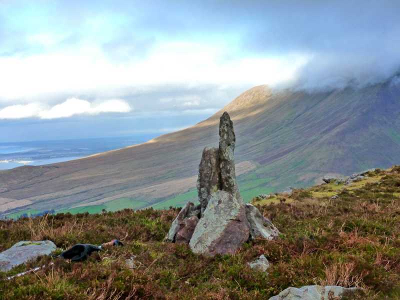
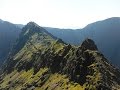
Picture: Summit marker with slopes of Caherconree in background
Park at A (Q717 056), the highest point of the Aughils to Camp road, where there is room for 1/2 cars. Head directly west, the ground cover being knee-high heather. After about 750m swing directly south taking you on to the col between Knockbrack and Lack. It is then a relatively easy climb of about 40m ascent to the small summit area which is a mixture of long grass and rock. The high point is marked by a vertical rock. 45 minutes from car to summit.
On the Castlemaine road heading to Inch 2km after bensons shop there is a lane way (800m long) up to a gate. From here it is an easy walk to the top. On a fine day you get a view across the bay of the Reeks and almost as far as Valentia. During the winter it is wet and gets very boggy. However there is a good trail cut now as a couple of us do the walk almost daily. When you are at the gate if you look up the mountain you will see the trail. When you reach the top, if you go east following the trail strictly (at least one bog hole in vicinity of trail). That trail will bring you down into the valley beside Caherconree with some great views of it as well. Linkback: mountainviews.ie/summit/564/comment/6667/
Read Less
Read More
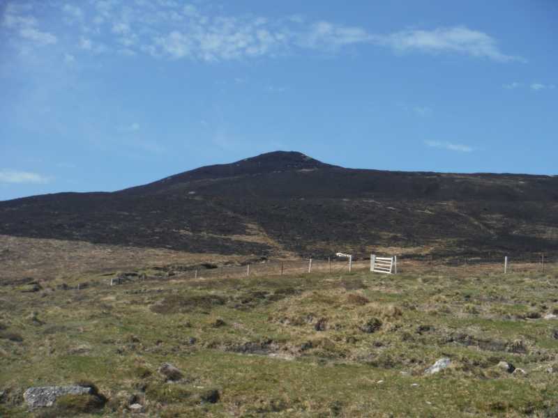
Picture: Lack mountain after recent fire
Black Lack
by markmjcampion
30 Apr 2015
Was up Lack mountain last week. There had been a significant fire the previous week which made the going really easy underfoot on the south-facing slopes. Strong smell of burnt bog too - a smell i like to be honest. Linkback: mountainviews.ie/summit/564/comment/17961/
Read Less
Read More
three5four0 on Lack Mountain
by three5four0
22 Sep 2009
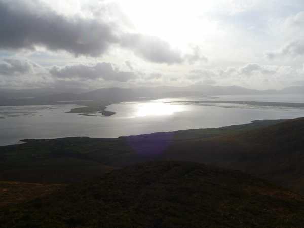
A short walk from Knockbrack to Lack, crossing a fence on the way. Looking down to Castlemaine Harbour from the summit you could clearly see lots of fishing boats, some appearing to going round in circles. Dredging perhaps.
Lack Mountain: A good start to the westerly Mish summits.
by stargazer
26 Apr 2010
We parked in a layby about 1/2 mile beyond Beheenagh (where many walkers begin the Caherconree ascent) coming from Camp. The layby coincides with an old bog track which we used for the early approach. The bog road eventually disappears and we used mountain sheep trails to complete a pleasant ascent to the summit. The view is impressive inlcuding a decent panorama taking in the other Slieve Mish summits of Caherconree and Caherbla to the east and Moanlaur and Beenduff further West. This is a really good platform for conquering some of the other summits such as Knockbrack, Moanlaur and even Emlagh if you get an early start. Linkback: mountainviews.ie/summit/564/comment/4662/
Use of MountainViews is governed by conditions and a privacy policy.
Read general information about the site. Opinions in material here are not necessarily endorsed by MountainViews.
Hillwalking is a risk sport. Information in comments, walks, shared GPS tracks or about starting places may
not be accurate for example as regards safety or access permission. You are responsible for your safety and your permission to walk.
See the credits and list definitions.


 Our Facebook page.