Cookies.
This website uses cookies, which are small text files that the website puts on your device to facilitate operation. Cookies help us provide a better service to you. They are used to track general user traffic information and to help the website function properly.
Features
Nearby features appear when you click the map.
Declutter tracks on map.
Place Search
Video
X
Pub: by
Central Dingle Area , Cen: Dromavally Subarea
Feature count in area: 25, all in Kerry, OSI/LPS Maps: 70, 71, 78, EW-DC, EW-DE, EW-DW
Highest Place: Beenoskee 826m

Starting Places (34) in area Central Dingle:
Anascaul Village, Annascaul Lake, Ballyduff Grave Yard, Brandon Village, Cloghane Community Centre, Conor Pass, Doonore South, Doorah, Dromavally Mountain SE, Emlagh Cross, Emlagh Wood, Farrannakilla School, Glan Mountain, Glanteenassig Lane, Glanteenassig Wood CP, Glennahoo River, Hostel Cloghane Village, Killiney R560 Junction, Kilmore Lodge, Lios Pole Church, Lisduff Rath, Lough Camclaun, Lough Caum, Lough Doon CP, Lougher, Maum Cross, Maumnahaltora Cross, Minard Beach, Mullaghveal Farm, Owenascaul Estuary, Pedlars Lodge, Pilgrimage Trail Owenmore River, Sauce Creek Walkway Dingle Way, Teerbrin

Summits & other features in area Central Dingle:
Cen: Annascaul Lake West: Cnoc na Bánóige 641.6m, Cnoc na Bánóige North Top 447.6m, Knockmulanane 593.2m, Knockmulanane West Top 563.5m
Cen: Dromavally: Cummeen 477m, Dromavally Mountain 552m, Knocknakilton 423m
N: Annascaul Lake North: Coombane 610m, Beenatoor 592m, Beenoskee 826m, Stradbally Mountain 798m
N: Carrigdav: Carrigadav 240m
N: Fermoyle: Farrandalouge 144m
S: Annascaul: Beenmore 252m, Brickany 374m, Knockafeehane 301m, Knocknanacree 286m
W: Ballyduff: Slievenalecka 458.4m, Beenbo 476.7m, Slievenagower 485.8m
W: Slieveanea: An Cnapán Mór 649m, Knockmoylemore 493m, Croaghskearda 608m, Slievanea 628.7m, Slievanea NE Top 670.7m

Note: this list of places may include island features such as summits, but not islands as such.
Rating graphic.
Cummeen, 477m Hill Sliabh an Choimín A name in Irish,
Place Rating ..
(Ir. Sliabh an Choimín [TCCD], 'mountain of the little hollow'), Carrignagower, Binn Bháin, Kerry County in Munster province, in Carn Lists, Cummeen is the 640th highest place in Ireland.
Grid Reference Q63040 07686, OS 1:50k mapsheet 71
Place visited by: 34 members, recently by: annem, maoris, chelman7, Moses, eiremoss34, Fergalh, liz50, thomas_g, eamonoc, Wilderness, gallybander, frankmc04, ciarraioch, madfrankie, chalky
I visited this place: NO (You need to be a logged-in member for this.)
Longitude: -10.004122, Latitude: 52.204399, Easting: 63040, Northing: 107686, Prominence: 162m,  Isolation: 1.7km
ITM: 463020 607740
Bedrock type: Rhythmically bedded sandstone, (Ballymore Sandstone Formation)
Notes on name: An Seabhac also mentions a peak called An Bhinn Bháin above Lough Acummeen, but this may refer to a cliff rather than the summit.
  Short or GPS IDs, 6 char: Cumen, 10 char: Cummeen

Linkback: https://mountainviews.ie/summit/524/
Gallery for Cummeen (Sliabh an Choimín) and surrounds
No summary yet for this place .
Member Comments for Cummeen (Sliabh an Choimín)
Comment create / edit display placeholder

            MountainViews.ie picture about Cummeen (<em>Sliabh an Choimín</em>)
Picture: On the ascent of Cummeen
Traverse to Anascaul
by three5four0 29 Aug 2011
On the ascent of Cummeen, and the start of a traverse over the hills to Anascaul lough. The track dbloke describes is clearly seen in the background. Linkback: mountainviews.ie/summit/524/comment/6494/
Read Less
Read More

Access problem in Glanteenassig, Kerry
by peter1 19 Aug 2020
Please note that the route suggested in dbloke's comment is now blocked by the farmer. I approached the farm house today to ask permission to ascend the track and was told that it was private property, as is the hanging valley above, and the hills either side of it. I was also told that I did not have permission to access the hills from Lough Slat as it is also private property. She told me that she 'has spent thousands of euro on fencing' to keep her sheep in and the public out. The gate to the farmyard carries the notice that security cameras are installed on the premises. Linkback: mountainviews.ie/summit/524/comment/20857/
Read Less
Read More

            MountainViews.ie picture about Cummeen (<em>Sliabh an Choimín</em>)
Picture: NW side of Cummeen
dbloke on Cummeen
by dbloke 4 Aug 2008
Suprisingly nobody has yet commented on Cummeen. It seems easily accessible from the Glanteenassig forest car park

at A (Q619 086). Walk back to the main road, turn right and follow it SW to the gate at B (Q617 080). Pass through the gate

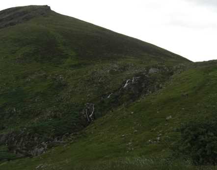
and follow the track as it gently meanders up the valley and past the waterfall. It's all very pleasant until the

track levels off and then diverges at C (Q622 073). From here on there is nothing but bog in every direction as far as

you can see. Following the track straight on will take you up towards Dromavally, whilst left crosses the river. At

this point I would suggest leaving the track and heading straight up the side of Cummeen. Following the track

further will lead you straight into the middle of the bog works and nowhere to go but to wade through knee-high

water-logged grass. If you make it past the bog and the flies don't eat you, the grass-covered summit of Cummeen

rewards you with a 360 panoramic view featuring the Magharees to the North and all the way to Clare, the Slieve Mish

mountains to the East, the Reeks to the south and Dromavally, Beenoksee and Stradbally to the West. Linkback: mountainviews.ie/summit/524/comment/3255/
Read Less
Read More

beanolan on Cummeen
by beanolan 5 Aug 2008
You can also climb Cummeen from the Glenteenassig road at the point where the small filter station is situated where the water pipe from Lake Acumeen comes down to the road. Climb up the rough hillside to the lake and then work you way around the shoulder to the summit. The filter station is on the left not far after the last farm. Sorry I have no Kerry map available to give the GR. Linkback: mountainviews.ie/summit/524/comment/3258/
Read Less
Read More
EDIT Point of Interest
text
Videos


Recent Contributions
x
Conditions and Info
Use of MountainViews is governed by conditions and a privacy policy.
Read general information about the site.
Opinions in material here are not necessarily endorsed by MountainViews.
Hillwalking is a risk sport. Information in comments, walks, shared GPS tracks or about starting places may not be accurate for example as regards safety or access permission. You are responsible for your safety and your permission to walk.
See the credits and list definitions.

OSi logo
OSNI/LPS logo
Open Street Map
(Various variations used.)
British summit data courtesy:
Database of British & Irish Hills