This website uses cookies, which are small text files that the website puts on your device to facilitate operation. Cookies help us provide a better service to you. They are used to track general user traffic information and to help the website function properly.
Sperrin MountainsArea, NE Cen: Glenelly North East
Subarea
Feature count in area: 64, by county: Derry: 34, Tyrone: 39, of which 9 are in both Derry and Tyrone,
OSI/LPS Maps: 12, 13, 6, 7, 8
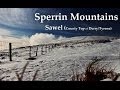
Highest Place: Sawel 678m
Starting Places (21) in area Sperrin Mountains: Altinure Road, Banagher Glen Nature Reserve, Barnes Gap Car Park, Crocknakin, Drumnaspar Picnic CP, Glenchiel Road, Glenedra Bridge, Glenelly Road, Parkreagh, Goles Road, Lough Ouske, Moneyneany Village, Moydamlaght Forest, Moydamlaght Road, Mullaghmore, Mullaghbane, Spaltindoagh, Sperrin Hamlet, Sperrin Heritage Centre, Sperrin Heritage Centre W, Sperrin Road, Barnes Top, Sperrin Road, Glashagh Bridge, Sperrin Road, Sperrin
Summits & other features in area Sperrin Mountains: E: Magherafelt Hills: Slieve Gallion NE Top 493.6m E: Magherafelt Hills: Slieve Gallion 526.6m N: Claudy Hills: Crockdooish 321m, Curradrolan Hill 270m, Eglish 277m, Letterlogher 249m, Mullaghmeash Hill 244m, Slieveboy 259m, Straid Hill 303m NE Cen: Glenelly North East: Barnes Top 456m, Craigagh Hill 460m, Crockbrack 526.1m, Knockanbane Mountain 441m, Meenard Mountain 620m, Meenard Mtn W Top 480m, Mullaghaneany 627m, Mullaghash 480m, Mullaghsallagh 485m, Oughtmore 569m, Spelhoagh 568m NE: Glenshane North: Benbradagh 465m, Boviel Top 454m, Carn Hill 448m, Carntogher 464m, Moneyoran Hill 414m NE: Glenshane South: Bohilbreaga 478m, Coolnasillagh Mountain 423m, Corick Mountain 430m, Crockalougha 407m, Mullaghmore 550m, White Mountain 537m NW Cen: Glenelly North West: Dart Mountain 619m, Dart Mountain North-West Top 525m, Learmount Mountain 489m, Learmount Mountain South Top 492m, Mullaghasturrakeen 581m, Mullaghcarbatagh 517m, Mullaghclogha 635m, Mullaghclogher 572m, Mullaghdoo 568m, Sawel 678m NW: Maheramason Hills: Clondermot Hill 220m, Gortmonly Hill 218m, Slievekirk 370m SE Cen: Glenelly South East: Carnanelly 562m, Carnanelly West Top 503.4m, Mullaghbane 467m, Mullaghturk 416m SE: Cookstown Hills: Cregganconroe 300m, Fir Mountain 362m, Oughtmore 382m SW Cen: Glenelly South West: Clogherny Top 408m, Craignamaddy 385m, Crocknamoghil 335m, Mullaghbolig 442m, Spaltindoagh 420m SW: Mullaghcarn: Curraghchosaly Mountain 416m, Mullaghcarn 542m, Mullaghcarn South Top 525m SW: Newtownstewart Hills: Bessy Bell 420m, Mullaghcroy 242m W: Strabane: Balix Hill 403m, Knockavoe 296m, Owenreagh Hill 400m
Note: this list of places may include island features such as summits, but not
islands as such.
Mullaghash, 480mHill Mullach Aise A name in Irish,
Place Rating ..
(prob. Ir. Mullach Aise [PDT], 'summit of the ridge'), Derry County in Ulster province, in Carn Lists, Mullaghash is the 629th highest place in Ireland.
Grid Reference C64070 01955,
OS 1:50k mapsheet 7 Place visited by: 40members, recently by: Colin Murphy, ChrisC, garybuz, Paddym99, Claybird007, Lucky1, Kilcoobin, Hoverla, trostanite, dregish, m0jla, eamonoc, Aidy, Welder, Fergalh
I visited this place: NO (You need to be a logged-in member for this.)
Short or GPS IDs, 6 char: Mlghsh, 10 char: Mullaghash Linkback: https://mountainviews.ie/summit/515/
Gallery for Mullaghash (Mullach Aise) and surrounds
Summary
for Mullaghash (Mullach Aise):
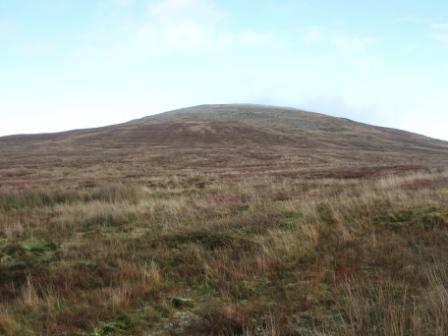
Steep sided hill with rough terrain.
Summary created by Colin Murphy
2023-12-07 15:56:17
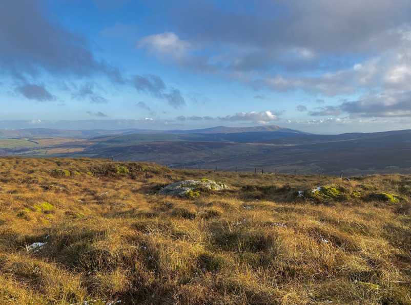
Picture: Summit area looking east.
One approach is via Barnes Top (see summary for that hill for approach.) Continue north from Barnes, dropping down to 280m at the col at A (C64732 01155), and crossing some marshy spots and a barbed wire fence. Continue north up the steep slope, navigating around heavy, tussocky grass. Eventually the grass is replaced by heather near the top. The unmarked high point is a slightly elevated heather mound. From car to summit via Barnes Top will take about 2 hours 15 minutes.
Another approach is from the west, via the Ballydonegan Sweat House and a track taking you some of the way. See comments below for more detail of this route.
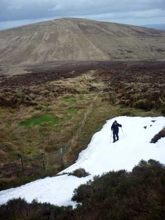
Picture: View of Mullaghash from the N slope of Barnes Top.
Harry Goodman on Mullaghash
by Harry Goodman
30 Mar 2010
On 23 March 2010 looking for a looped walk over the three tops of Mullaghash, Barnes Top and Knockanbane Mountain we started at an open yard with an old public house (closed!) and other outbuildings, beside the roadside at Inchinagh B (C62398 02490). In view of a number of carts and other farm machinery I was unsure about parking there but this doubt was quickly dispelled by the sheep farmer who owned the property and who readily invited us to park. Indeed in discussion with him he told us that he also owned the land on Knockanbane Mt. and had no problem with us walking there as long as we made sure to close any gates. Initially like others who have commented on this hill we walked NE along the road to an old farm lane on the right signed for Ballydonegan Sweat House where we turned right and walked down to a wooden bridge on the left. We crossed this bridge (which starts the short walk to the Sweat House) and walked around the field to another bridge which we also crossed . A sign board about the Sweat House is at the top left corner of the field. We went through a gate at the top right and then left down to and across a stream before a short walk up to a fence. We then turned right and followed the fence along to its high point on the NW shoulder of Mullaghash where we turned left across the fence and then made our way directly to the top of the hill. The climb was very typical of many hills in the Sperrins gradual but long, extending upwards on a good walking surface for about 1.3k crossing a number of false tops on the way. From the summit area we had views N to Inishowen and Slieve Snaght, to Binevenagh and Ben Braddagh to the East and the full splendour of the High Sperrins Ridge to the S. While there is discussion in other comments about the top of this hill possibly being one of the large rocks on or near the flatish summit area I favour a point on the heathery/peaty top consistent with the MV Grid Reference C (C641 020). However, as is so common in these hills, one could be going around in circles arguing about which tuft of heather/peat is actually the high point! From the top we picked up a fence going S down to the coll with Barnes Top about 1k below. At the coll, had we not opted to climb Barnes Top, we could have walked SW to pick up a track at D (C63700 00950) which we could have followed around the bulk of Mullaghash back down to the road and our start point. Linkback: mountainviews.ie/summit/515/comment/4554/
Read Less
Read More
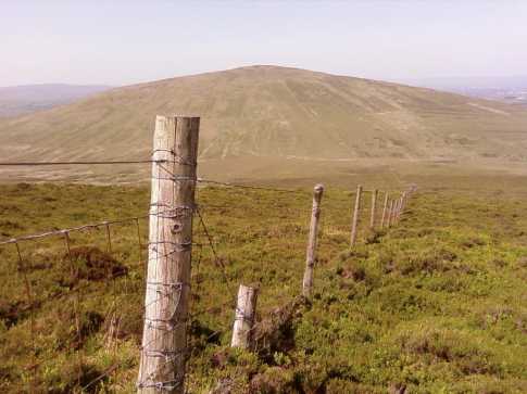
Picture: Mullaghash from Barnes Top
gerrym on Mullaghash
by gerrym
13 Jun 2007
I started this walk off the Moneyeany to Feeny B40, at E (C662 031) take the concrete farm lane, this is overgrown in places. There is room to park just after a cattle grid or further along as the track forks. At the fork go right and drop down to a picturesque ford (F (C658 023)) across the Owenbeg river, beside a splash of purple from a stand of foxgloves. I met some impressively horned sheep here who seemed to have as impressive an attitude as they stood thier ground and stared me out, while i hurried on with head bowed. The river is crossed again by a bridge of worringly decaying sleepers and tin sheets, yes i did test it out gingerly but am sure it has held far greater weight than mine. The track climbs alongside the river as it drops, with the ever present sound of water heightened by a series of small waterfalls. At a place you feel appropriate drop down and cross the river, maybe stopping as i did to take in the pools of water, rocks and overhanging trees - the word beautiful comes to my mind. Cross a fence and climb over mature ground which is quite arduous but was a least dry. Views to the N bring the jutting point of Benbradagh and further still to the steep steps of Binevenaghs cliff face. Nearer to the top there is a change to shorter vegeatation and random boulders of all sizes. The top is crossed by a fenceline (N-S) and again has more mature ground underfoot, being reached in under one hour. Due to its profile and slightly isolated position from the surrounding hills there is an impressive perspective far and wide. The already mentioned N views extend to Inishowen and the height of Slieve Snaght, down the length of the Derryveagh mtns with all the distintive tops and on to the Bluestacks as come S. This also brings the vision of the big central Sperrin hills from Mullaghmore all the way to Mullaghcarbatagh.
I found a large boulder on which to perch and eat lunch (just as the fence drops down to the S) and survey the majesty of what was before me as the N breeze created clouds out of the blue sky which drifted thier shadows up and over the Sperrins to the S. An easy drop of 15 mins along the fence brings the birthing place of a couple of rivers amid a sea of grass. This was wet even after the dry weather of so many weeks. A left turn would follow the Owenbeg river back to the points already described or an excess of energy could be burned off by tackling the 400m hills ahead (Barnes Top, Knockanbane mountain to name but two). Linkback: mountainviews.ie/summit/515/comment/2738/
Read Less
Read More
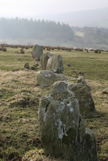
Picture: Auglish Stone Circle
Richard on Mullaghash
by Richard
7 Jan 2010
Ballydonegan Sweathouse is one of the sites on the North Sperrins Heritage Trail. If you have time its worth the short diversion. There are a number of other archaeological sites on the trail nearby such as Auglish Stone Circle. Many of the sites relate to the wider landscape and in particular the hills. Further info on the trail is available free from www.sperrinsheritage.com Linkback: mountainviews.ie/summit/515/comment/4338/
Read Less
Read More
Well hidden Sweat House
by m0jla
23 Jun 2019
16/05/2019 We found this much easier than expected. Parked, with permission, in the yard of the cottage by the sign to the Sweat House and followed the path to the display panel. Failed to find any sign of the Sweat House so went on our way, crossing the stream shortly and making our way beside the lowest of the four parallel fences. A gate leads through the end fence of this field system, giving access to the hill which we ascended ; hard work. Descent by the same route, finding the Sweat House this time by looking across the dell behind the information panel from around 30m North of the panel. Linkback: mountainviews.ie/summit/515/comment/20557/
Read Less
Read More
Picture: Mullaghash from the wooden gate
pquinn572 on Mullaghash
by pquinn572
21 Dec 2009
I climbed Mullaghash yesterday, Saturday the 19th of December. I did so in the company of the West Tyrone Ramblers as we climbed high into the Sperrins on a cold winters morning. We started the walk 3 miles outside Park on the road to Feeny (B44) at an old public house, Labelled on OS map. It is 300m up the road from Ballydonegan sweat house which is signposted. We parked here and headed down the road to the small cottage and the signpost for the sweat house. We followed a lane around the right hand side of the house and then turned left on another lane leading down to a river. There is a wooden bridge crossing the river which leads to the sweat house however do not cross it but continue up the lane. After 500m or so you pass some outbuildings on your right, rounding a gate you continue on the track which gradually begins to turn to the left. Then you come to a river, cross it and continue on the path up the hill. You then cross the river again before reaching an iron gate, go through it and continue along the path. Here the path is quite cut up and wet so walking on the bank is the best. You then reach another gate, this time a wooden one go through it, then continue. At this stage the path begins to peter out. Follow the fence line on your left hand side across the foot of the mountain (you may need to cross it as this side of it is very wet). This fence then meets another fence which goes straight up the mountain on your left hand side. Follow this to the top. The exact top is not marked however a huge boulder would appear to be the summit. I descended via the same route following the fence back down and then over to the track. The track leads back through the gates, passing the out buildings and onto the road. A challenging but rewarding walk. I recommend that you do it on a clear day to enjoy the views. Linkback: mountainviews.ie/summit/515/comment/4311/
Use of MountainViews is governed by conditions and a privacy policy.
Read general information about the site. Opinions in material here are not necessarily endorsed by MountainViews.
Hillwalking is a risk sport. Information in comments, walks, shared GPS tracks or about starting places may
not be accurate for example as regards safety or access permission. You are responsible for your safety and your permission to walk.
See the credits and list definitions.


 Our Facebook page.