This website uses cookies, which are small text files that the website puts on your device to facilitate operation. Cookies help us provide a better service to you. They are used to track general user traffic information and to help the website function properly.
Sperrin MountainsArea, NE Cen: Glenelly North East
Subarea
Feature count in area: 64, by county: Derry: 34, Tyrone: 39, of which 9 are in both Derry and Tyrone,
OSI/LPS Maps: 12, 13, 6, 7, 8
Highest Place: Sawel 678m
Starting Places (21) in area Sperrin Mountains: Altinure Road, Banagher Glen Nature Reserve, Barnes Gap Car Park, Crocknakin, Drumnaspar Picnic CP, Glenchiel Road, Glenedra Bridge, Glenelly Road, Parkreagh, Goles Road, Lough Ouske, Moneyneany Village, Moydamlaght Forest, Moydamlaght Road, Mullaghmore, Mullaghbane, Spaltindoagh, Sperrin Hamlet, Sperrin Heritage Centre, Sperrin Heritage Centre W, Sperrin Road, Barnes Top, Sperrin Road, Glashagh Bridge, Sperrin Road, Sperrin
Summits & other features in area Sperrin Mountains: E: Magherafelt Hills: Slieve Gallion NE Top 493.6m E: Magherafelt Hills: Slieve Gallion 526.6m N: Claudy Hills: Crockdooish 321m, Curradrolan Hill 270m, Eglish 277m, Letterlogher 249m, Mullaghmeash Hill 244m, Slieveboy 259m, Straid Hill 303m NE Cen: Glenelly North East: Barnes Top 456m, Craigagh Hill 460m, Crockbrack 526.1m, Knockanbane Mountain 441m, Meenard Mountain 620m, Meenard Mtn W Top 480m, Mullaghaneany 627m, Mullaghash 480m, Mullaghsallagh 485m, Oughtmore 569m, Spelhoagh 568m NE: Glenshane North: Benbradagh 465m, Boviel Top 454m, Carn Hill 448m, Carntogher 464m, Moneyoran Hill 414m NE: Glenshane South: Bohilbreaga 478m, Coolnasillagh Mountain 423m, Corick Mountain 430m, Crockalougha 407m, Mullaghmore 550m, White Mountain 537m NW Cen: Glenelly North West: Dart Mountain 619m, Dart Mountain North-West Top 525m, Learmount Mountain 489m, Learmount Mountain South Top 492m, Mullaghasturrakeen 581m, Mullaghcarbatagh 517m, Mullaghclogha 635m, Mullaghclogher 572m, Mullaghdoo 568m, Sawel 678m NW: Maheramason Hills: Clondermot Hill 220m, Gortmonly Hill 218m, Slievekirk 370m SE Cen: Glenelly South East: Carnanelly 562m, Carnanelly West Top 503.4m, Mullaghbane 467m, Mullaghturk 416m SE: Cookstown Hills: Cregganconroe 300m, Fir Mountain 362m, Oughtmore 382m SW Cen: Glenelly South West: Clogherny Top 408m, Craignamaddy 385m, Crocknamoghil 335m, Mullaghbolig 442m, Spaltindoagh 420m SW: Mullaghcarn: Curraghchosaly Mountain 416m, Mullaghcarn 542m, Mullaghcarn South Top 525m SW: Newtownstewart Hills: Bessy Bell 420m, Mullaghcroy 242m W: Strabane: Balix Hill 403m, Knockavoe 296m, Owenreagh Hill 400m
Note: this list of places may include island features such as summits, but not
islands as such.
Meenard Mtn W Top, 480mHill
Place Rating ..
For origin of name, see Meenard Mountain., Tyrone County in Ulster province, in Carn Lists, Meenard Mtn W Top is the 625th highest place in Ireland.
Grid Reference H64632 98262,
OS 1:50k mapsheet 13 Place visited by: 69members, recently by: Paddym99, Sperrinwalker, garybuz, ElaineM76, Carolyn105, nickywood, Kilcoobin, dregish, Iamcan, wicklore, eamonoc, Eamonconnolly, trostanite, ciaranr, pearnett
I visited this place: NO (You need to be a logged-in member for this.)
Longitude: -6.994746, Latitude: 54.828213, Easting: 264632, Northing: 398262,
Prominence: 45m, Isolation: 1.8km ITM: 664592 898277 Bedrock type: Psammite & semipellite, (Dart Formation) Notes on name: Cloghornagh is a feature lower down, probably the Irish name for the County Rock.
Short or GPS IDs, 6 char: MnrdMt, 10 char: MnrdMtnWTp Linkback: https://mountainviews.ie/summit/514/
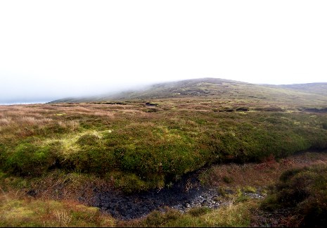
From the parking spot at point A (H639 974), Meenard West Top is a brief, boggy hike about 1km NE. The photo taken at the 'summit' is actually of its bigger brother Meenard Mt to the west. Meenard West Top's summit is undefined and actually difficult to identify exactly - is it that peat hag or this one or that one over there? In fact the best thing I can say about it is that it's an easy walk with pleasant views. Linkback: mountainviews.ie/summit/514/comment/3407/
Read Less
Read More
Easier ascent.
by hivisibility
6 Oct 2015
For an easier ascent from the parking space at point A (H639 974) turn right along the road and continue until you meet a timber gate shortly after on your right. Climb over and ascend slightly to the left over grass terrain. Much easier than trying to follow the fence from the cattle grid, dodging peat hags and knee high heather. Linkback: mountainviews.ie/summit/514/comment/18349/
Use of MountainViews is governed by conditions and a privacy policy.
Read general information about the site. Opinions in material here are not necessarily endorsed by MountainViews.
Hillwalking is a risk sport. Information in comments, walks, shared GPS tracks or about starting places may
not be accurate for example as regards safety or access permission. You are responsible for your safety and your permission to walk.
See the credits and list definitions.


 Our Facebook page.