This website uses cookies, which are small text files that the website puts on your device to facilitate operation. Cookies help us provide a better service to you. They are used to track general user traffic information and to help the website function properly.
Feature count in area: 34, all in Mayo,
OSI/LPS Maps: 22, 23, 24, 30, 31, 37, 38, CBE, CBW, EW-ACC
Highest Place: Claggan Mountain West Top 365m
Starting Places (37) in area Mayo Coastal Hill: Achillbeg Island, Achillbeg Mid West Beach, Balloor, Ben Goram Road, Bunanioo Church, Bunleemshough River Source, Bunnageeha, Bunnahowna Bridge, Bunnahowna River, Burrishoole Loop, Carnhill, Carrowmore Hill South, Cartron River, Cregganbaun, Erris Head, Foher, Glendahurk Bridge, Illaunroe North, Illaunroe South, Kilgeever Wood, Kinknock, Lettergesh Beach, Lough Gall, Muck Lough NW, Mulranny Post Office, Murrisk Fishermans Monument, Old Head, Owengar Bridge, Portacloy Bay, Proesoon, Prospect Lough Road, Rossnafinna Island, Sean Scoil an Talaimh Bháin, Silver Strand Road, Tawnydoogan Forest Central, Termon Hill Road, Tower Hill South
Summits & other features in area Mayo Coastal Hill: Barnacuillew E.Top 242m, Benwee NE Head 111m, Carricklea 95m, Claggan Hill 53m, Claggan Hill 74m, Claggan Mountain West Top 365m, Cone Hill 105m, Corraduff Hill 221m, Derrylahan 59m, Dooghill 204m, Doonvinalla E Top 117m, Doonvinalla N Top 135m, Doonvinalla W Top 164m, Drumcollagh Hill 52m, Erris Head Hill 82m, Geevraun Point 196m, Glendorragh Point Hill 82m, Gubacarrigan 56m, Illanbaun Hill 113m, Kilcommon Hill 104m, Kilgalligan Hill 120m, Knocknagnauve 67m, Knockshanbo Hill 56m, Lackakeely 56m, Lackan Hill 62m, Mullaghnacross Hill 55m, Old Head 102m, Raheen 107m, Roscahill Hill 56m, Rosgalliv Hill 51m, Rossbeg Hill 57m, Rostoohy Hill 51m, Trawoughter Hill 117m, Westport Demesne Hill 54m
Note: this list of places may include island features such as summits, but not
islands as such.
Doonvinalla N Top, 135mCoastal Hill
Place Rating ..
OSI. Name from nearby coastal feature, G from Logainm, Mayo County in Connacht province, in no lists Grid Reference F83836 45399,
OS 1:50k mapsheet 22 Place visited by: 4members, recently by: jlk, Cathal-Kelly, IncaHoots, mountainmike
I visited this place: NO (You need to be a logged-in member for this.)
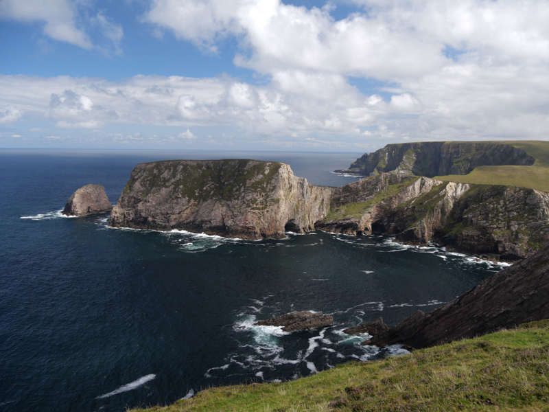
Looking across to Doonvinalla N Top from E Top i decided it was above my pay grade to attempt the summit climb today . But to the right of the photo a route to the top seemingly exists so another day maybe. Linkback: mountainviews.ie/summit/5066/comment/19695/
Read Less
Read More
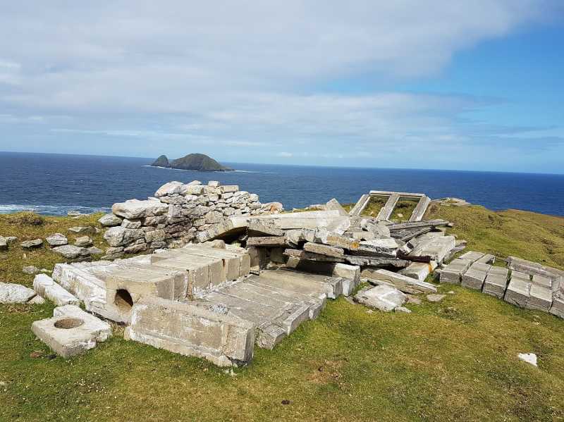
Picture: Look out Post.
Coastal Hill
by sandman
14 Aug 2018
On 26/4/2014 i spent a very enjoyable afternoon walking this area visiting the army observation hut and the stone constructed EIRE marking as part of an addition to the Benwee Head Loop walk but i did not visit this hill . The closest access is via the Portacloy Pier A (F83958 44259) following the signs of the loop walk and on towards Doonvinalla E Top .
[ Note. The lookout point is on a ridge to the right of and separated by water from the main Doonvinalla N Top peninsula.] Linkback: mountainviews.ie/summit/5066/comment/19665/
Use of MountainViews is governed by conditions and a privacy policy.
Read general information about the site. Opinions in material here are not necessarily endorsed by MountainViews.
Hillwalking is a risk sport. Information in comments, walks, shared GPS tracks or about starting places may
not be accurate for example as regards safety or access permission. You are responsible for your safety and your permission to walk.
See the credits and list definitions.


 Our Facebook page.