This website uses cookies, which are small text files that the website puts on your device to facilitate operation. Cookies help us provide a better service to you. They are used to track general user traffic information and to help the website function properly.
Feature count in area: 34, all in Mayo,
OSI/LPS Maps: 22, 23, 24, 30, 31, 37, 38, CBE, CBW, EW-ACC
Highest Place: Claggan Mountain West Top 365m
Starting Places (37) in area Mayo Coastal Hill: Achillbeg Island, Achillbeg Mid West Beach, Balloor, Ben Goram Road, Bunanioo Church, Bunleemshough River Source, Bunnageeha, Bunnahowna Bridge, Bunnahowna River, Burrishoole Loop, Carnhill, Carrowmore Hill South, Cartron River, Cregganbaun, Erris Head, Foher, Glendahurk Bridge, Illaunroe North, Illaunroe South, Kilgeever Wood, Kinknock, Lettergesh Beach, Lough Gall, Muck Lough NW, Mulranny Post Office, Murrisk Fishermans Monument, Old Head, Owengar Bridge, Portacloy Bay, Proesoon, Prospect Lough Road, Rossnafinna Island, Sean Scoil an Talaimh Bháin, Silver Strand Road, Tawnydoogan Forest Central, Termon Hill Road, Tower Hill South
Summits & other features in area Mayo Coastal Hill: Barnacuillew E.Top 242m, Benwee NE Head 111m, Carricklea 95m, Claggan Hill 53m, Claggan Hill 74m, Claggan Mountain West Top 365m, Cone Hill 105m, Corraduff Hill 221m, Derrylahan 59m, Dooghill 204m, Doonvinalla E Top 117m, Doonvinalla N Top 135m, Doonvinalla W Top 164m, Drumcollagh Hill 52m, Erris Head Hill 82m, Geevraun Point 196m, Glendorragh Point Hill 82m, Gubacarrigan 56m, Illanbaun Hill 113m, Kilcommon Hill 104m, Kilgalligan Hill 120m, Knocknagnauve 67m, Knockshanbo Hill 56m, Lackakeely 56m, Lackan Hill 62m, Mullaghnacross Hill 55m, Old Head 102m, Raheen 107m, Roscahill Hill 56m, Rosgalliv Hill 51m, Rossbeg Hill 57m, Rostoohy Hill 51m, Trawoughter Hill 117m, Westport Demesne Hill 54m
Note: this list of places may include island features such as summits, but not
islands as such.
Doonvinalla E Top, 117mCoastal Hill Cnoc an Dúna A name in Irish,
Place Rating ..
OSI. Name from nearby coastal feature, G from Logainm, Mayo County in Connacht province, in no lists Grid Reference F83826 44985,
OS 1:50k mapsheet 22 Place visited by: 19members, recently by: markwallace, Fergalh, jlk, Djouce, bryanjbarry, Cathal-Kelly, Caithniadh, Tomaquinas, justynagru, Lauranna, magnumpig, ucampbell, simon3, markmjcampion, gerrym
I visited this place: NO (You need to be a logged-in member for this.)
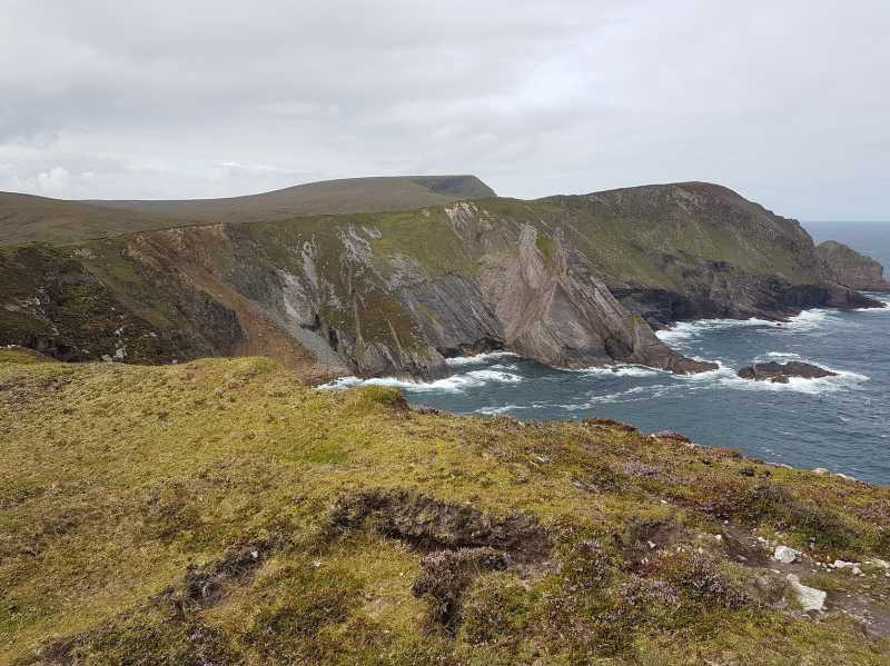
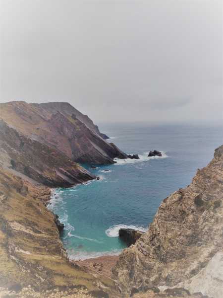
Easy access from the pier at Portacloy A (F83958 44259) follow the Benwee Loop walk and branch off where appropriate . The photo shows views across towards Benwee Head in the background . Linkback: mountainviews.ie/summit/5064/comment/19696/
Read Less
Read More
Last Pre-Corona Peak
by magnumpig
14 Apr 2020
I climbed this coastal hill on the 21st of March, which was before the total lockdown came into effect, and while it has only been 3 and a half weeks it feels like years since I was wandering around north Mayo. The photo was taken from approx 200metres southwest of the East Top, on the way to the West Top. The North Top is not something I was going to chance on my own on a damp March evening, so left that one behind me, but it's a spectacular cliff top walk here in a wonderfully isolated part of the country Linkback: mountainviews.ie/summit/5064/comment/20778/
Use of MountainViews is governed by conditions and a privacy policy.
Read general information about the site. Opinions in material here are not necessarily endorsed by MountainViews.
Hillwalking is a risk sport. Information in comments, walks, shared GPS tracks or about starting places may
not be accurate for example as regards safety or access permission. You are responsible for your safety and your permission to walk.
See the credits and list definitions.


 Our Facebook page.