This website uses cookies, which are small text files that the website puts on your device to facilitate operation. Cookies help us provide a better service to you. They are used to track general user traffic information and to help the website function properly.
Feature count in area: 57, by county: Cork: 32, Kerry: 36, of which 11 are in both Cork and Kerry,
OSI/LPS Maps: 83, 84, 85, 88
Highest Place: Hungry Hill 682m
Starting Places (51) in area Caha Mountains: Ardgroom, Barley Lake North, Bere Island Pier, Caha Pass, Canshanavoe South, Carriganine, Cashelkeelty Stone Circles Carpark, Castletownbere Lifeboat Harbour, Clashduff River Farm, Coolieragh Harbour Road, Coomadayallig Lake Road N, Coomadayallig Lake Road S, Cooryeen Lane, Cummer Lough East Road, Derreenataggart Stone Circle Road, Dromoghty Lough North, Dunboy Wood, Esk Boreen, Eyeries, Fehanah Lane, Garinish Island Pier, Glantrasna Bridge, Glenbeg Lough N, Glengarriff, Glengarriff Nature Reserve CP, Gleninchaquin Waterfall, Gowlaun Lough, Healy Pass, Healy Pass Hairpin, Ilnacullin Car Park, Kenmare Bridge, Knockacullin Lane, Leahill Bog, Leitrim Beg Standing Stone, Lough Inchiquin SE, Magannagan Stream, Molly Gallivan's Visitor Centre, Nora's Cottage, Old Lansdowne School, Owgarriff River Lane, Peg's Shop, Pooleen Wood Car Park, Red Trout Lake, Reenroe Bridge, River Drimminboy Track, Rossmackowen Bridge, Rossmackowen Cemetery, Shronebirrane Farm, Shronebirrane Road, Toberbanaha, Turner's Rock Tunnel
Summits & other features in area Caha Mountains: Cen: Hungry Hill: Coombane 510m, Derryclancy 554m, Hungry Hill 682m Cen: Knockowen: Cushnaficulla 594m, Glenkeel Top 417m, Knockastumpa 398m, Knockeirky 577m, Knockeirky South Top 523m, Knockowen 658m, Stookeennalackareha 412m E: Glengarriff: Derrynafulla SW 375m, Gowlbeg Mountain 362m, Nareera 530m, Nareera North Top 503m, Nareera South-West Top 505m, Shrone Hill 283m, Sugarloaf Mountain 574m, Sugarloaf Mountain Far West Top 560m, Sugarloaf Mountain West Top 565m N: Coomnadiha: Baurearagh Mountain 489m, Caha Far SE Top 555m, Caha SE Top 585m, Coomnadiha 644m, Coomnalack Top 435m, Cummeenbaun 510m, Droppa 522m, Killane Mountain 537m, Killane Mountain South-West Top 533m, Knockagarrane 414m, Knockreagh 500m N: Knockeirka: Barraduff Mountain 400m, Killaha Mountain 400m, Knockeirka 426m N: Knocknagorraveela: Derrysallagh 410m, Feorus East 474m, Knocknagorraveela 507m, Knocknagorraveela NE Top 464m N: Lauragh: Knockanoughanish 386m, Knockatee 330m S: Castletownbere: Disert 205m, Knockanallig (Bear Island) 267m W: Ardgroom: Derryvour Hill 160m W: Eskatarriff: Coomacloghane 599m, Eskatarriff 600.5m, Eskatarriff East Top 532.7m, Knocknaveacal North Top 509.1m, Knocknaveacal South Top 507.2m, Lackabane 603m, Tooreenbaha 408.7m, Tooreennamna 524m, Tooth Mountain 592m W: Knocknagree: Knocknagree 586m, Knocknagree East Top 461m, Knocknagree SE Top 442m, Lackawee 572m, Maulin 621m, Maulin North Top 579m
Note: this list of places may include island features such as summits, but not
islands as such.
Baurearagh Mountain, 489mHill Sliabh Bharr Iarthach A name in Irish,
Place Rating ..
(Ir. Sliabh Bharr Iarthach [OSI], 'mountain of Barr Iarthach or western top'), Kerry County in Munster province, in Carn Lists, Baurearagh Mountain is the 601st highest place in Ireland.
Grid Reference V88470 60555,
OS 1:50k mapsheet 85 Place visited by: 58members, recently by: bandre, maoris, Superterence, miriam, learykid, Wilderness, Geo, mountainmike, JohnRea, annem, jackos, chelman7, gernee, ilenia, tfm9
I visited this place: NO (You need to be a logged-in member for this.)
Longitude: -9.616996, Latitude: 51.786734, Easting: 88470, Northing: 60555,
Prominence: 34m, Isolation: 1.5km ITM: 488444 560619 Bedrock type: Purple & green sandstone & siltstone, (Caha Mountain Formation) Notes on name: Baurearagh is a townland at the western end of the Sheen river valley.
Short or GPS IDs, 6 char: BrrgMn, 10 char: BrrghMntn Linkback: https://mountainviews.ie/summit/486/
Gallery for Baurearagh Mountain (Sliabh Bharr Iarthach) and surrounds
Summary
for Baurearagh Mountain (Sliabh Bharr Iarthach):
A boggy but easy ascending slope from the roadside
Summary created by jackill
2012-07-30 08:11:32
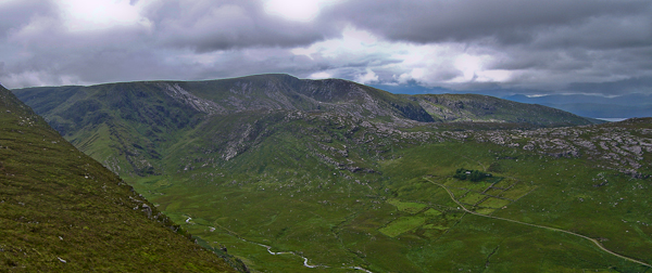
Picture: The quiet valley of the Baurearagh river
Park on the Kerry side of the tunnel at about Caha Pass (V901 605) where there is room for a few cars on the roadside.
Walk down the road towards kerry looking for a grassy ramp on your left
Go up the grassy ramp to gain the ridge.
Head west along the ridge to the summit area crossing 3 fences on the way.
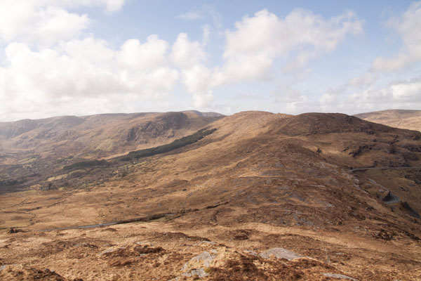
Picture: Baurearagh from Turner's rock, with Killane, Coomnadiha and Knocknagorraveela behind
scapania on Baurearagh Mountain
by scapania
5 Apr 2010
Probably best to climb this long whaleback ridge from the gate on the Kerry side of the biggest tunnel at the top of the Caha pass at about Caha Pass (V9012 6057), there's parking for a couple of cars here. Just head through the gate, up to the top of the ridge and follow the stout fence up a short, steep slope and along the 1.5km ridge to the summit area. There's an abundance of fences around here but most are easily enough crossed, if you find the right point. Good views from the summit down over Glengariff and across to the Reeks and Iveragh. Logically, you would continue on to nearby Killane Mountain from here, but due to a late start and deciding to climb Turner's Rock first and follow the undulating ridge across the top of the Tunnel, Killane will have to wait for another day. Linkback: mountainviews.ie/summit/486/comment/4591/
Use of MountainViews is governed by conditions and a privacy policy.
Read general information about the site. Opinions in material here are not necessarily endorsed by MountainViews.
Hillwalking is a risk sport. Information in comments, walks, shared GPS tracks or about starting places may
not be accurate for example as regards safety or access permission. You are responsible for your safety and your permission to walk.
See the credits and list definitions.


 Our Facebook page.