This website uses cookies, which are small text files that the website puts on your device to facilitate operation. Cookies help us provide a better service to you. They are used to track general user traffic information and to help the website function properly.
Feature count in area: 58, all in Down,
OSI/LPS Maps: 20, 29, EW-CLY
Highest Place: Slieve Donard 849m
Starting Places (33) in area Mourne Mountains: Alex Steddom Tree, Aughrim Airstrip, Ben Crom Dam, Bloody Bridge Car Park, Carlingford Greenway, Carrick Little, Crocknafeola Wood, Crotlieve Mountain, Donard Car Park Newcastle, Drummanmore Picnic, Fofanny Reservoir, Forest Office CP, Gamekeepers Lodge CP, Happy Valley Trassey Rd, Hen Mountain CP, Leitrim Lodge CP, Mayo Road Corner, Meelmore Lodge, Newcastle Harbour, Ott CP, Red Bog Road, Rourkes Park, Sandy Brae, Silent Valley Reservoir Head Rd, Slieve Donard Trail Head, Slieve Foye Viewing Point, Slievefoy Forest CP, Spelga Dam E, Spelga Dam N, Spelga Dam S, Trassey Car Park, Two Mile River CP, Yellow Water Park
Summits & other features in area Mourne Mountains: Cen: Loughshannagh: Ben Crom 526m, Carn Mountain 585.2m, Carn Mountain North Top 553.7m, Doan 592.6m, Ott Mountain 526.8m, Slieve Loughshannagh 617m, Slieve Muck 670.4m, Slievenaglogh 445m E: Binnian: Slieve Binnian 745.9m, Slieve Binnian East Top 639m, Slieve Binnian North Top 678m, Slieve Binnian North Tor 682.5m, Wee Binnian 460m E: Donard: Chimney Rock Mountain 656m, Crossone 540m, Millstone Mountain 460m, Rocky Mountain 524m, Slieve Donard 849m E: Lamagan: Cove Mountain 654.8m, Slieve Beg 595.9m, Slievelamagan 702.2m N: Bearnagh: Slieve Bearnagh 739m, Slieve Bearnagh North Tor 680m, Slieve Meelbeg 701.9m, Slieve Meelmore 687m N: Castlewellan: Slievenalargy 280m, Slievenaslat 272m N: Commedagh: Slieve Commedagh 767m, Slieve Corragh 641.9m, Slievenaglogh 584.4m, Slievenaglogh East Top 571m N: Croob: Cratlieve 429m, Slieve Croob 534m, Slievegarran 391m, Slievenisky 446m N: Rathfriland: Knockiveagh 235m S: Kilkeel: Knockchree 306m S: Rostrevor: Crenville 460m, Finlieve 578m, Slievemartin 485m, Slievemeel 420m, Slievemeen 472m W: Hilltown: Gruggandoo 382m, Slieveacarnane 296m W: Slievemoughanmore: Crotlieve Mountain 347m, Eagle Mountain 638m, Rocky Mountain 404m, Shanlieve 626m, Slievemoughanmore 560m, Tievedockaragh 473m, Wee Slievemoughan 428m W: Spelga: Butter Mountain 500m, Cock Mountain 504m, Cock Mountain South-West Top 505m, Hen Mountain 354m, Pigeon Rock Mountain 534m, Pigeon Rock Mountain South Top 530m, Slievenamiskan 444m
Note: this list of places may include island features such as summits, but not
islands as such.
Ott Mountain, 526.8mMountain Ucht A name in Irish,
Place Rating ..
(Ir. Ucht [PNNI], 'mountain-breast'), Down County in Ulster province, in Arderin Lists, Ott Mountain is the 483rd highest place in Ireland.
Grid Reference J28364 26957,
OS 1:50k mapsheet 29 Place visited by: 279members, recently by: Dee68, Henning86, Magic, Carolineswalsh, ElaineM76, garybuz, SenanFoley, Timmy.Mullen, Lyner, Nailer1967, derekfanning, abptraining, NualaB, osullivanm, Ansarlodge
I visited this place: NO (You need to be a logged-in member for this.)
Longitude: -6.034956, Latitude: 54.175567, Easting: 328365, Northing: 326957,
Prominence: 30.6m, Isolation: 0.8km ITM: 728285 826962 Bedrock type: Mudstone, greywacke & conglomerate, (Deep marine turbidite sequence) Notes on name: This peak overlooks the top of the mountain road between Fofanny Dam and Attical. Ucht literally means 'breast', and applied to landscape it can translated as 'mountain-breast' or 'flank'. It is frequently found with mám, 'pass', e.g. Ucht Máma in Co. Clare or Mám Uchta in Co. Galway. It is possible in the name in question that ucht applies to the flank of mountain crossed by the road (or an earlier track) at its highest point. The top of Ott Mountain is only half a mile from this section of the road.
Short or GPS IDs, 6 char: OtMntn, 10 char: OtMntn Linkback: https://mountainviews.ie/summit/461/
Gallery for Ott Mountain (Ucht) and surrounds
Summary
for Ott Mountain (Ucht):
A stoney track but a boggy end
Summary created by jackill
2014-09-03 12:58:20
Park in the carpark on the Slievenaman Road at Ott CP (J28000 27863) , room for 10 cars. Across the road use the stile to hop the wire fence and follow a good track to A (J28570 27085), then head south west across the bog for 250 meters to gain the summit on a small outcrop.
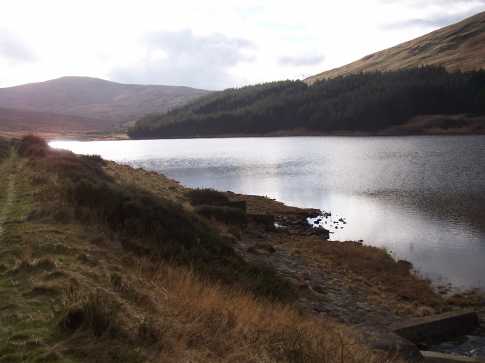
A good light intro to the Mournes, nice to see it has been given recognition in Mountainviews. Easy access to the summit from the track of the same name off Slievenaman Road, but a much more enjoyable and testing walk is to tackle it along the route in the picture following the Ulster way from Fofanny Dam. Once summited, drop down to the Mourne Wall and decide to tackle Carn and Muck in one direction, Loughshannagh and the Meels in another or the Silent Valley includin Doan and Ben Crom. Linkback: mountainviews.ie/summit/461/comment/2366/
Read Less
Read More
Alex92 on Ott Mountain
by Alex92
10 Feb 2009
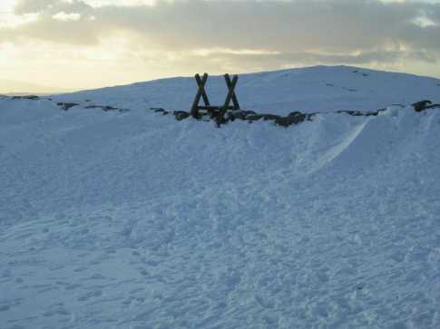
Ott (seen rising above the wall) is a hill everyone has heard about, but not many have actually climbed! Staying true to form, there were no other wakers to be found on it's summit last weekend. In their place however were a couple of eejits on quad bikes. From the pic you can see the extent of the snowfall in the hills last week. The snow had drifted so high in parts that it completely covered the wall on both sides, so you could effectively walk over the wall! I found this highly amusing. Linkback: mountainviews.ie/summit/461/comment/3585/
Read Less
Read More
Picture: The view North from Ott Mountain
NICKY on Ott Mountain
by NICKY
20 Mar 2007
We had the pleasure of free time to do a lovely walk in the Mournes on 30th December 2006. Our route took us from the car park below Slievenamuck, up the Ott track, Ott mountain, Carn mountain and finally Slieve Muck down to the car park south of Spelga Dam. This was a wonderful walk. The cloud formations were very dramatic, more so as the walk progressed. For our start Ott mountain is not a distinctive peak but it was a great stepping stone to the higher peaks. When doing this walk your lungs and legs gradually strengthen which is great for the not so fit! I would recommend this route for those of you that are pressed for time but want dramatic views (Slieve Muck)! Linkback: mountainviews.ie/summit/461/comment/2643/
Read Less
Read More
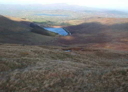
Picture: Ott in the centre of the pic, with Butter in the background. Viewed from the col between Slieve Loug
Alex92 on Ott Mountain
by Alex92
29 Apr 2007
Unlike the majority of people who hike in the Mournes, I enjoy mountains like Ott. Why? Because you can guarantee that no-one will be at the top when you reach it, and you'll have the whole mountain to yourself... unlike the high-traffic areas of Donard and such like. Park at the Blue Quarry/Ott Car park off the Slievenaman road, and approach from the Ott track. You can follow the track which branches off to the summit of Ott, but I prefer a different approach. My favourite way would be to leave the track half way up, and to head directly to the summit. This (believe it or not) provides some scrambling over steep ground to the summit, and is quite testing! Believe me, do not dismiss Ott or the other minor mountains in the Mournes. If you look at the mountain and try to figure out alternative ways of approaching it, which could make the hike more difficult or challenging, you can fully enjoy what these hills have to offer. Linkback: mountainviews.ie/summit/461/comment/2679/
Read Less
Read More
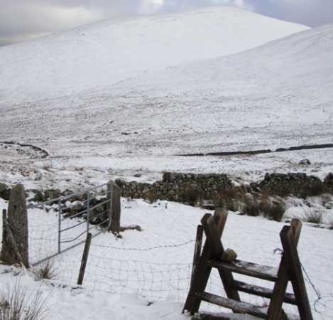
Picture: The stile at ott road carpark with Meelbeg lurking in the background
darrenf on Ott Mountain
by darrenf
7 Jan 2010
Set off on a simple ott-carn-loughshannagh-meelbeg route on January 3rd. The plan was to park at the small car park on the ott road at Ott CP (J280 278), however it wasnt the ice or snow that put this plan to bed but rather the scores of cars and jeeps parked along the ott road enjoying the recent snowfalls. Instead we parked at the junction of the B27 and the Ott road at B (J277 267) and walked along the road to the aforementioned carpark. A stile at this carpark gives direct access to Ott mountain along a well established track. The track actually skirts around Ott but the top can easily be tackled using this track. Refer to Carn Mountain for rest of route. Linkback: mountainviews.ie/summit/461/comment/4344/
Use of MountainViews is governed by conditions and a privacy policy.
Read general information about the site. Opinions in material here are not necessarily endorsed by MountainViews.
Hillwalking is a risk sport. Information in comments, walks, shared GPS tracks or about starting places may
not be accurate for example as regards safety or access permission. You are responsible for your safety and your permission to walk.
See the credits and list definitions.


 Our Facebook page.