This website uses cookies, which are small text files that the website puts on your device to facilitate operation. Cookies help us provide a better service to you. They are used to track general user traffic information and to help the website function properly.
Antrim HillsArea, Cen: Central Antrim Hills
Subarea
Feature count in area: 27, all in Antrim,
OSI/LPS Maps: 14, 15, 4, 5, 8, 9
Highest Place: Trostan 550m
Starting Places (3) in area Antrim Hills: Donalds Carn, Rathlin Island Ferry Port, Whitehead Golf Club
Summits & other features in area Antrim Hills: Cen: Central Antrim Hills: Carncormick 436m, Collin Top 429m, Crockalough 402m, Mid Hill 440m, Skerry Hill 459m, Slieveanorra 508m, Slievenahanaghan 418m, Soarns Hill 403m, Tievebulliagh 402m, Trostan 550m Central Antrim Hills: Slievenanee 543m N: North Antrim Hills: Carnanmore 379m, Croaghan 417m, Crockaneel 403m, Cross Slieve 206m, Knocklayd 514m, Lannimore Hill 207m N: Rathlin Island: Kilpatrick (Rathlin Island) 134m S: Islandmagee: Donalds Carn 141m, Muldersleigh Hill 131m S: South Antrim Hills: Agnew's Hill 474m, Big Collin 353m, Black Hill 381m, Carnearny 319m, Douglas Top 402m, Slemish 437.9m W: West Antrim: Long Mountain 215m
Note: this list of places may include island features such as summits, but not
islands as such.
Slieveanorra, 508mMountain Sliabh an Earra A name in Irish,
Place Rating ..
(Ir. Sliabh an Earra [DUPN], 'mountain of the tail/ridge') Orra More an extra name in English, Antrim County in Ulster province, in Arderin Lists, Slieveanorra is the 546th highest place in Ireland.
Grid Reference D13400 26600,
OS 1:50k mapsheet 5 Place visited by: 139members, recently by: sprog, aaronm002, Moirabourke, mountainmike, AlanReid, Arcticaurora, headspace, Paddym99, garybuz, Cecil1976, Leonas_Escapades, Claybird007, No1Grumbler, srr45, Portosport
I visited this place: NO (You need to be a logged-in member for this.)
Longitude: -6.225473, Latitude: 55.073759, Easting: 313400, Northing: 426600,
Prominence: 178m, Isolation: 4.5km ITM: 713324 926583 Bedrock type: Olivine basalt lava, (Lower Basalt Formation) Notes on name: The Battle of Orra, between the McQuillans and McDonnells, took place on this mountain in 1559. The McQuillans were Lords of the Route and the dominant clan of the region. The McDonnells were a family originating from Scotland who usurped the McQuillans' castles and land.
Short or GPS IDs, 6 char: Slvnr, 10 char: Slvnr Linkback: https://mountainviews.ie/summit/440/
Gallery for Slieveanorra (Sliabh an Earra) and surrounds
Summary
for Slieveanorra (Sliabh an Earra):
no wellies required
Summary created by slemish
2010-11-18 18:12:47
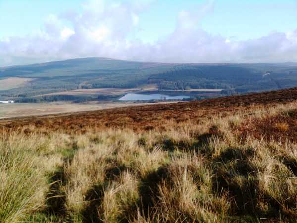
Picture: Slieveanorra as seen from nearby Slievenahanaghan
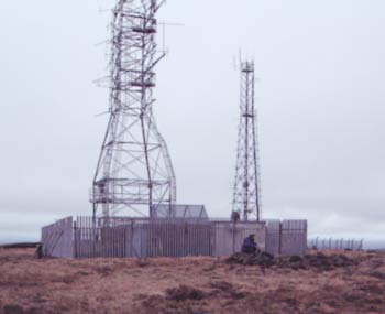
Slieveanorra is one of the most accessible of the Antrim Hills since its summit can be reached via gravel tracks. The easiest route up follows the Moyle Way south-west from the car park on the well-signposted Orra scenic route (A (D144 277)) whilst the much longer option is to approach fom the south through the vast Slieveanorra forest. This mountain is well positioned for long views to the Scottish coast and various isles as well as the Sperrins and the rest of the Antrim hills. The summit area is spoilt somewhat by the presence of two huge masts which are very much an eyesore.
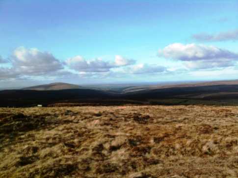
Picture: Looking north from Slieveanorra summit to Knocklayd and Rathlin
slemish on Slieveanorra
by slemish
23 Apr 2009
Despite being one of the easiest mountains to climb in this part of Antrim, Slieveanorra is one of the best for views. Trostan and Slievenanee may be higher but as they are so close together they block part of the view from each other. Getting to the summit of Slieveanorra is simple. Park at the lay-by where the Moyle Way crosses the Orra scenic route between Magherahoney and Cushendall (B (D144 277)). Then it's a simple trek up the gravel track through the forest and over the open mountainside. The summit at 508m is marked by a small cairn behind one of the ugly masts. This afternoon was particularly clear and the views were majestic. Starting in the east the Donegal hills were clearly visible, then through the full length of the Sperrins. To the south, Slemish was peeking through the gap between Trostan and Slievenanee with the craggy outline of the distant Mournes behind. To the west, Lurigethan and Tievebulliagh but the best view of all was north to Knocklayd with Rathlin Island beyond and further still, the hills of Islay and the unmistakeable Paps of Jura to the right. Simply outstanding views and an easy climb. Total trip can be done in less than an hour. Linkback: mountainviews.ie/summit/440/comment/3685/
Read Less
Read More
NICKY on Slieveanorra
by NICKY
8 Mar 2007
An excellent circular walk in which to include Slievanorra starts at the main road on the Northern side. Take the forest track directly opposite the Slievanorra track and follow it to the end. Then turn right along a lovely country road. When you come to the next junction turn left and left again. After 1,1/2kms there is a track on the right hand side. This will lead to the minor hills of Aghan, 372mtrs then Eshery 382 mtrs. Just head for the highest point and keep going in a straight line. When you have arrived on Eshery, Trostan will be visible straight ahead. Climb Trostan for the highest point in County Antrim. Next, come off Trostan on it's Western Side. It will lead you down to the posts of the Moyle Way, then a footbridge and finally to the road. Then turn right to follow the road until you come to the first forest track on the left. Take this track through Slievanorra forest to the end then turn left followed by the first right. This will lead out onto the open moorland. If you follow a faint track this will lead to Slievanorra's summit on the right hand side of the ugly hideous masts. Enjoy the views from my closest mountain. When ready to return to your transport just follow the service road on the Northern side of the mountain to it's end. Enjoy! Linkback: mountainviews.ie/summit/440/comment/2635/
Read Less
Read More
simon3 on Slieveanorra
by simon3
16 Apr 2004
The summit of Slieveanorra definitely isn’t a wilderness experience. For a start it has two masts on it with associated buildings and it also has two roads. From the top a metalled road leads SE, whilst a well maintained dirt track leads NE. I approached it from the main road at A (D144 277) (the NE side).
From the summit there is a good view of the windfarm on Slievenahanagan, some 5 or 6 km to the SW. At the summit there is a small ring of stones, overshadowed by the modern high tech structures. Linkback: mountainviews.ie/summit/440/comment/930/
Use of MountainViews is governed by conditions and a privacy policy.
Read general information about the site. Opinions in material here are not necessarily endorsed by MountainViews.
Hillwalking is a risk sport. Information in comments, walks, shared GPS tracks or about starting places may
not be accurate for example as regards safety or access permission. You are responsible for your safety and your permission to walk.
See the credits and list definitions.


 Our Facebook page.