This website uses cookies, which are small text files that the website puts on your device to facilitate operation. Cookies help us provide a better service to you. They are used to track general user traffic information and to help the website function properly.
Feature count in area: 57, by county: Cork: 32, Kerry: 36, of which 11 are in both Cork and Kerry,
OSI/LPS Maps: 83, 84, 85, 88
Highest Place: Hungry Hill 682m
Starting Places (51) in area Caha Mountains: Ardgroom, Barley Lake North, Bere Island Pier, Caha Pass, Canshanavoe South, Carriganine, Cashelkeelty Stone Circles Carpark, Castletownbere Lifeboat Harbour, Clashduff River Farm, Coolieragh Harbour Road, Coomadayallig Lake Road N, Coomadayallig Lake Road S, Cooryeen Lane, Cummer Lough East Road, Derreenataggart Stone Circle Road, Dromoghty Lough North, Dunboy Wood, Esk Boreen, Eyeries, Fehanah Lane, Garinish Island Pier, Glantrasna Bridge, Glenbeg Lough N, Glengarriff, Glengarriff Nature Reserve CP, Gleninchaquin Waterfall, Gowlaun Lough, Healy Pass, Healy Pass Hairpin, Ilnacullin Car Park, Kenmare Bridge, Knockacullin Lane, Leahill Bog, Leitrim Beg Standing Stone, Lough Inchiquin SE, Magannagan Stream, Molly Gallivan's Visitor Centre, Nora's Cottage, Old Lansdowne School, Owgarriff River Lane, Peg's Shop, Pooleen Wood Car Park, Red Trout Lake, Reenroe Bridge, River Drimminboy Track, Rossmackowen Bridge, Rossmackowen Cemetery, Shronebirrane Farm, Shronebirrane Road, Toberbanaha, Turner's Rock Tunnel
Summits & other features in area Caha Mountains: Cen: Hungry Hill: Coombane 510m, Derryclancy 554m, Hungry Hill 682m Cen: Knockowen: Cushnaficulla 594m, Glenkeel Top 417m, Knockastumpa 398m, Knockeirky 577m, Knockeirky South Top 523m, Knockowen 658m, Stookeennalackareha 412m E: Glengarriff: Derrynafulla SW 375m, Gowlbeg Mountain 362m, Nareera 530m, Nareera North Top 503m, Nareera South-West Top 505m, Shrone Hill 283m, Sugarloaf Mountain 574m, Sugarloaf Mountain Far West Top 560m, Sugarloaf Mountain West Top 565m N: Coomnadiha: Baurearagh Mountain 489m, Caha Far SE Top 555m, Caha SE Top 585m, Coomnadiha 644m, Coomnalack Top 435m, Cummeenbaun 510m, Droppa 522m, Killane Mountain 537m, Killane Mountain South-West Top 533m, Knockagarrane 414m, Knockreagh 500m N: Knockeirka: Barraduff Mountain 400m, Killaha Mountain 400m, Knockeirka 426m N: Knocknagorraveela: Derrysallagh 410m, Feorus East 474m, Knocknagorraveela 507m, Knocknagorraveela NE Top 464m N: Lauragh: Knockanoughanish 386m, Knockatee 330m S: Castletownbere: Disert 205m, Knockanallig (Bear Island) 267m W: Ardgroom: Derryvour Hill 160m W: Eskatarriff: Coomacloghane 599m, Eskatarriff 600.5m, Eskatarriff East Top 532.7m, Knocknaveacal North Top 509.1m, Knocknaveacal South Top 507.2m, Lackabane 603m, Tooreenbaha 408.7m, Tooreennamna 524m, Tooth Mountain 592m W: Knocknagree: Knocknagree 586m, Knocknagree East Top 461m, Knocknagree SE Top 442m, Lackawee 572m, Maulin 621m, Maulin North Top 579m
Note: this list of places may include island features such as summits, but not
islands as such.
Eskatarriff East Top, 532.7mMountain Eisc an Tairbh (mullach thoir) A name in Irish,
Place Rating ..
For origin of name, see Eskatarriff. Name Bireca from Richard Mersey, The Hills of Cork & Kerry. Bireca an extra name in English, Kerry County in Munster province, in Arderin, Irish Best Hundred Lists, Eskatarriff East Top is the 467th highest place in Ireland.
Grid Reference V74285 53150,
OS 1:50k mapsheet 84 Place visited by: 118members, recently by: Lucy.boland, miriam, Tuigamala, Krzysztof_K, Sweeney, chelman7, a3642278, johncusack, NualaB, jackos, mh400nt, John.geary, daitho9, annem, hivisibility
I visited this place: NO (You need to be a logged-in member for this.)
Short or GPS IDs, 6 char: EsktEs, 10 char: EsktrfEstT Linkback: https://mountainviews.ie/summit/391/
Gallery for Eskatarriff East Top (Eisc an Tairbh (mullach thoir)) and surrounds
Summary
for Eskatarriff East Top (Eisc an Tairbh (mullach thoir)):
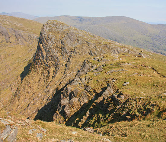
Steep sided jutting peak.
Summary created by simon3
2013-06-13 17:16:48
Picture: Eskatarriff East from the west.
This is an extraordinarily shaped piece of rock jutting out into Rabach's Glen. Most likely it will be accessed as part of the circuit of that Glen. It could be reached from the north in Rabach's Glen or south from the Glanmore River side. The north face of the summit is a nearly sheer 300m, however the south side is a relatively benign slope.
A somewhat comparable peak would be Ben Lugmore in the Mweelrea Mountains and a nearer comparison would be Droppa near Cummeenbaun.
Needless to say this could be a dangerous place in wind or wintery conditions.
Climbed this as part of S to N crossing of the Beara Penninsula (along the Cork Kerry Border) starting S of Hungry Hill and finishing in Ardgroom. Hungry Hill was wonderfull with great views to the S & E, and was followed by a pleasant lunch beside Glas Loughs (Ref:A (V738 502))where my dog had numerous swims. From here to Eskatariff things started to go (metaphorically speaking) downhill. I expected the valley S of Eskatarriff to be wet, but as the weather had been dry for a number of weeks, I gave it a go. As expected, the ground was dry, however, the high marsh grass was something else. I fought my way through waist high grass for about a kilometer until I reached the start of the ascent (E of Clogher). To my despair I realised that the deep grass continued almost to the summit of Eskatarriff. I have never come across such terrain on an ascent before, and do not look forward to meeting it again. My dog went underground for the duration and occassionally had to leap up through the grass to see daylight. From Eskatarriff I crossed NW and was rewarded with a magnificant descent into the sunset heading W along the Tooreennamna ridge. This ridge has fantastic views N to the Iveragh Peninisula, the Kenmare River and Ardgroom Harbour, W to the Skelligs and SW to Glenbeg Lough. Word of warning: The W end of the ridge is very steep and rocky and descent is not recommended. I descended NW by one of the steep grassy gullies before reaching the end of the ridge. The overall route would be magnificant but for the Clogher valley, which would be made worse after wet weather when the deep grass would be accompanied soft ground. It may be possible to make the crossing over better ground via the col between Maulin N and Eskatarriff (Ref:B (V722 518)). Linkback: mountainviews.ie/summit/391/comment/1103/
Read Less
Read More
eoin on Eskatarriff East Top
by eoin
23 Apr 2004
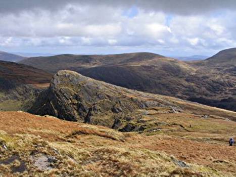
The dramatic rock dome summit on the Cummeengeera Horseshoe walk above Rabach's Glen near Lauragh. Just beyond Eskatarriff this summit is much more dramatic than its bigger brother to the west.
Eskatarriff East is one of those places that looks incredibly intimidating near to. And indeed the area has had at least one accident, when on 10th October 2010 Kerry Mountain Rescue team were placed on standby after a female walker broke her ankle on the ridge just below Eskatarriff. The Team were subsequently stood down after it was confirmed that the casualty had been successfully airlifted by the Shannon Coast Guard helicopter.
However from across the glen its cliff doesn't appear so steep and it is surrounded on the left and right by higher points on the ridge. Even behind it Hungry Hill looms in the distance. Linkback: mountainviews.ie/summit/391/comment/15020/
While it's not as high as its immediate neighbours, Eskatarriff E's steep cliff offers unrestricted views down the glen Linkback: mountainviews.ie/summit/391/comment/16060/
Read Less
Read More
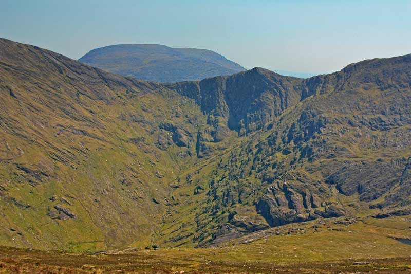
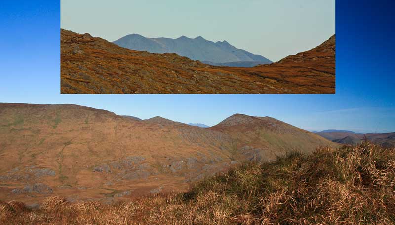
Picture: Eskatarriffs from the south. (Reeks, inset)
Eskatarriff East and a mighty view to the Reeks.
by simon3
2 Jun 2014
Unsung, Eskatarriff East deserves yet another picture, this time from the south, the Knocknagree area.
Serendipitously, part of the Reeks appears in the keyhole between Eskatarriff East Top and Lackabane (to the right). Linkback: mountainviews.ie/summit/391/comment/15021/
Use of MountainViews is governed by conditions and a privacy policy.
Read general information about the site. Opinions in material here are not necessarily endorsed by MountainViews.
Hillwalking is a risk sport. Information in comments, walks, shared GPS tracks or about starting places may
not be accurate for example as regards safety or access permission. You are responsible for your safety and your permission to walk.
See the credits and list definitions.


 Our Facebook page.