This website uses cookies, which are small text files that the website puts on your device to facilitate operation. Cookies help us provide a better service to you. They are used to track general user traffic information and to help the website function properly.
Feature count in area: 18, by county: Dublin: 16, Wicklow: 7, Kildare: 1, of which 6 are in both Dublin and Wicklow,
OSI/LPS Maps: 43, 50, 56, AWW, EW-DM, EW-WE, EW-WW
Highest Place: Kippure 757m
Starting Places (77) in area Dublin: Allagour Road, Ballinascorney Golf Club, Ballylerane, Ballylow Bridge, Ballyreagh Wood, Ballyross Forest, Ballysmuttan Long Stone, Barnaslingan Wood, Bohernabreena North CP, Boranaraltry Bridge, Bray Harbour, Cabinteely House, Cannon's Corner, Carrickgollgan, Castelkelly Bridge, Clonkeen Road South, Cloon Wood Cp, Cransillagh Brook , Crone Wood CP, Cruagh Forest Recreation Area, Cruagh Road Hairpin, Curtlestown Wood CP, Dunnes Bank, Enniskerry, Fernhill Estate, Gap Road, Garadhu Road, Glencree Reconciliation, Hell Fire Wood CP, Johnnie Fox Pub, Kilbride Army Camp Entrance, Kilgobbin Lane, Killakee Car Park, Killiney Hill Carpark, Kilmashoge Forest CP, Kilsaran Quarry, Kippure Bridge, Kippure Estate, Kippure Transmitter Gate, Knockbrack, Knockree west, Lackan Wood S, Lamb Doyles, Laughanstown Luas, Lee's Lane, Liffey Bridge, Liffey Head Bridge, Lough Bray Lower, Lough Bray Upper, Lynch's Park Road, Marley Park CP, Novara Avenue, Bray, Old Wicklow Way entrance, Pavilion Theatre, Pine Forest Road, Putland Road, Raheenoon, Rathmichael RC Church, Rathmichael Wood CP, Sally Gap, Sally Gap N, Seahan 265', Seahan 300', Sean Walsh Park, Seefin Trailhead, Shankill Byrnes Bar, Shankill Tributary Bridge, Slademore Road, Sraghoe Brook, St Catherine's Park, The Lamb Hill, The Scalp, Tibradden Forest Recreation Area, Tibradden Lane, Ticknock Forest, Vance's Lane, Wyattville Close
Summits & other features in area Dublin: N: Howth: Ben of Howth 171m N: Naul: Knockbrack 176m S: Dublin South East: Carrickgollogan 275.2m, Glendoo Mountain 585.1m, Killiney Hill 153.5m, Knocknagun 555.3m, Montpelier Hill 383m, Prince William's Seat 553.5m, Tibradden Mountain 466.2m, Two Rock Mountain 536m S: Kippure & Kilbride: Corrig Mountain 617.1m, Kippure 757m, Seahan 647.3m, Seefin 620.6m, Seefingan 722.9m S: Saggart: Cupidstown Hill 378.6m, Knockannavea 400.8m, Saggart Hill 396.9m
Note: this list of places may include island features such as summits, but not
islands as such.
Two Rock Mountain, 536mMountain Sliab Lecga A name in Irish,
Place Rating ..
(Ir. Sliab Lecga [MD], 'mountain of flagstones') Fairy Castle an extra name in English, Black Mountain, Dublin County in Leinster province, in Arderin Lists, Two Rock Mountain is the 456th highest place in Ireland.
Grid Reference O17218 22380,
OS 1:50k mapsheet 50 Place visited by: 715members, recently by: Krzysztof_K, muddyboots, Padraigin, MartMc, davidrenshaw, MeabhTiernan, ToughSoles, Carolineswalsh, Tommer504, Tuigamala, McWobbley, CianDavis, JohnHoare, Kaszmirek78, PrzemekPanczyk
I visited this place: NO (You need to be a logged-in member for this.)
Longitude: -6.24512, Latitude: 53.239168, Easting: 317218, Northing: 222380,
Prominence: 171m, Isolation: 2.4km, Has trig pillar
ITM: 717139 722413 Bedrock type: Muscovite-microcline porphyritic granite, (Type 4 muscovite/microcline porphyritic) Notes on name: The summit is known as Fairy Castle. The Sliab Lecga name has been proposed by some scholars but is not officially recognised by Logainm
Short or GPS IDs, 6 char: TwRckM, 10 char: TwRckMntn Linkback: https://mountainviews.ie/summit/382/
Gallery for Two Rock Mountain (Sliab Lecga) and surrounds
Summary
for Two Rock Mountain (Sliab Lecga):
A focal point for many walks
Summary created by osullivanm
2014-04-14 11:02:16
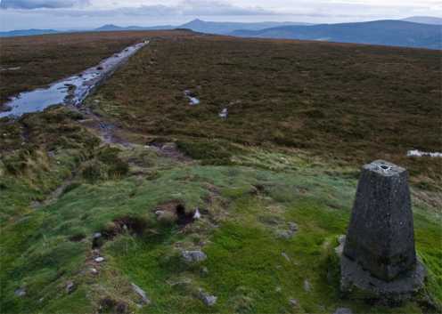
Picture: Looking South
Two Rock Mountain has a pre-historic cairn known as "Fairy Castle" marking it's summit. There are panoramic views from the top which include Mullacleevaun, Tonlegee, the Sugarloaf , Cooleys and Mournes as well as interesting views of Dublin City and the East Coast.
It's a focal point for for many walks including "Sunday afternoon strolls" and longer walks which might incorporate parts of the Wicklow Way (From Marlay Park to Cloneygal in Carlow) or the newer Dublin Mountains Way( From Tallaght to Shankhill). The development work for these trails has helped to contain the significant erosion at the top.
It's an easily accessible mountain, some of the more popular routes would be from Tibraddan Car Park (Tibrad (O1380 2284)) or Glencullen (A (O1910 2060)), using the DMW. From Marlay Park or Kilmashogue Car Park (B (O1520 2440)) using the Wicklow Way. From the East side, starting at the Blue Light Pub (C (O1809 2413)) and walking via Three Rock Mountain or, starting at Kilgobbin Cemetary (D (O1891 2438)), for a longer walk using the old mass path from Barnacullia to Sandyford Church .. see track 800.
I have read that the name ‘Two Rock’ does not appear before the 19th century. In earlier maps, it seems, the place is referred to as ‘Black Mountain’, which, to my mind, is a perfect description of the mire that walkers have to trudge through on some of the approaches. The highest point on Two Rock is marked, of course, by the pre-historic cairn known as ‘Fairy Castle’ (E (O1721 2238)), on top of which a more recent pyramid or cone of rocks continues to grow at the whim of latter-day Flintstones. The original cairn underneath stands almost 3m high today, though it would be logical to think it has shrunk over the centuries through subsidence and erosion. I have seen reference to the remains of a kerb around the outer edge of the cairn, of which twenty-two stones are supposedly still in position, but today’s cloak of earth and vegetation makes it rather difficult to verify that. I am surprised to find no reference to any excavation of the cairn, especially since it has been surmised that it may contain a chamber similar to the one on Seefin. What strikes me most about this somewhat bleak though splendidly panoramic mountain is the fact that there are so many other prehistoric monuments on all sides. There is a burial cairn on Tibradden, a wedge tomb at Kilmashogue, and another at Ballyedmonduff, all within a short walk. It shows that from the late Stone Age onwards there were well-organised social communities living close to this mountain and climbing it like ourselves, though not, I suppose, with the same recreational intentions.
The photo was taken from on top of the 'cone' on Fairy Castle, looking southwards along the dark shoulder of Two Rock. On the horizon is the triangle of the Great Sugar Loaf and the distinctive saddle of the Little Sugar Loaf. Linkback: mountainviews.ie/summit/382/comment/3376/
Read Less
Read More
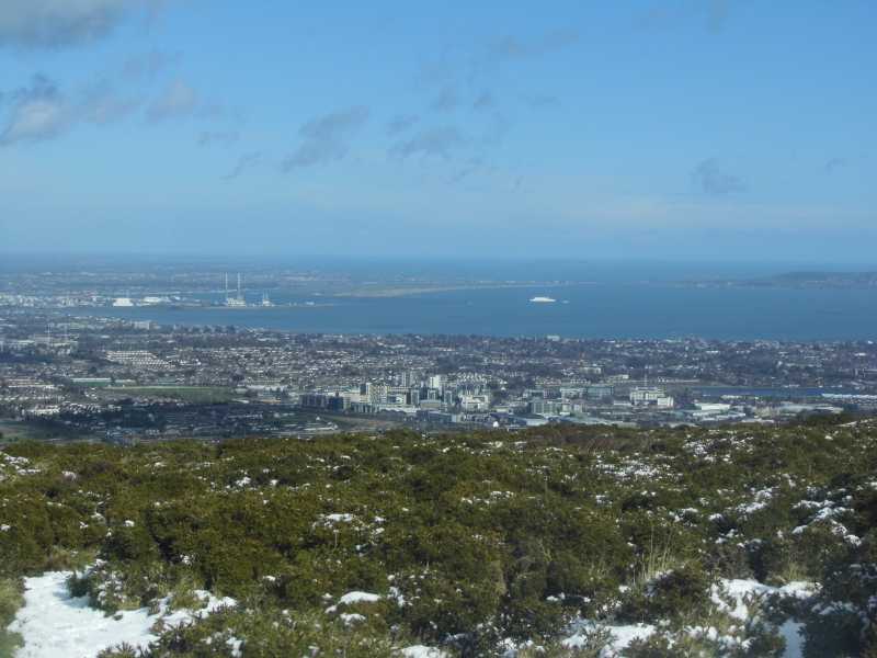
Picture: Dublin City from Three Rock mountain.
I remember Dublin City.......
by TommyV
11 Mar 2019
As mentioned by murphysw, the Kilmashogue forest car park is a good starting point for this walk. I followed this path all the way to the masts at Three Rock Mountain and I would recommend it as the views of Dublin City from here are second to none. From here there is an obvious trail heading South up to the cairn and trig on top of Fairy Castle with great views over to the Wicklow Mountains. From here follow the trail South West for about 500 metres before coming to a junction where the trail forks. Take the route to the right which will bring you back to the main Coilte road from the start of the walk. Follow this for about two kilometers and you will be back at the car park. The route is just over 9km if you find yourself near the capital with a couple of hours to spare and the weather allows for it, I would highly recommend. Linkback: mountainviews.ie/summit/382/comment/20450/
Read Less
Read More
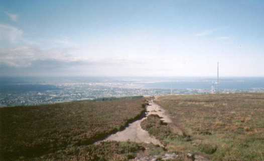
Picture: Dublin Bay from Fairy Castle
murphysw on Two Rock Mountain
by murphysw
24 Sep 2005
Parked the car in the Kilmashogue car park for an evening stroll to the summit. The Wicklow Way leads up a very clear and wide path until it disappears up to the right through the forest near the summit. I decided to continue straight as judging by the paths on the OS map it looked quicker. Dont bother! It just leads out to a tarmac road which takes you by the array of tv masts on your way to the summit. The summit itself gives you great views of dublin and over towards Kippure (pity I left the camera in the glovebox). Descended by the path to the Wicklow Way, and down the Way itself. Disconcertingly the path ends in a dead end at the forest. If you retrace your steps a few yards you will see a tree marked with a white X. Enter the forest here and it is only a very short distance back to the path. The picture i've added here was taken on a different stroll to the summit, on a bright, clear autumn day. The picture I've added was taken on a different climb, on a bright, clear, autumn day. Linkback: mountainviews.ie/summit/382/comment/1869/
Read Less
Read More
evelyn on Two Rock Mountain
by evelyn
1 Mar 2005
Had a stroll on Sunday 27th Feb up here to play in the snow! Have lapsed recently in reaching the top of mountains - (too busy with my horse!) - but as I'm off to the Scottish Highlands and the Swiss Alps in June thought I should get a few mountains under the boot! Boy is the path from 3 rock up to Fairy Castle eroded.... it's such a pity really as it's a nice "family" walk and good introduction for youngsters to the hills, I met 2 scramblers on the eroded path, walkers were tending to trample the heather which will make the path even wider!! Linkback: mountainviews.ie/summit/382/comment/1507/
Read Less
Read More
brenno on Two Rock Mountain
by brenno
22 Jan 2007
Was up Two Rock on Jan 20th - walked from Pine Forest to Two Rock and back again. Great visibility but very cold especially when walking back to Pine Forest into the teeth of the wind.
I know boardwalks are a necessary evil on routes like the Spink and from Luggala to Djouce, but there are also some sections between Pine Forest and Two Rock that are getting badly eroded with the track getting wider and wider as people avoid the swamp in the middle. I don't know who's actually responsible for doing stuff like this in the Dublin area and since it's well outside the boundaries of the Wicklow national park. Boardwalk for the badly eroded sessions wouldn't need to be very long - the worst sections only extend over a few hundred metres before you're back onto the usual gravelly/stony surface in the area. Linkback: mountainviews.ie/summit/382/comment/2591/
Use of MountainViews is governed by conditions and a privacy policy.
Read general information about the site. Opinions in material here are not necessarily endorsed by MountainViews.
Hillwalking is a risk sport. Information in comments, walks, shared GPS tracks or about starting places may
not be accurate for example as regards safety or access permission. You are responsible for your safety and your permission to walk.
See the credits and list definitions.


 Our Facebook page.