This website uses cookies, which are small text files that the website puts on your device to facilitate operation. Cookies help us provide a better service to you. They are used to track general user traffic information and to help the website function properly.
Feature count in area: 15, all in Donegal,
OSI/LPS Maps: 1, 2, 6
Highest Place: Moylenanav 539m
Starting Places (28) in area Donegal Central: Astelleen Burn Waterfall, Ballyarr, Binnadoo, Braughan Road, Drumfin Bridge, Edenacarnan East, Edenacarnan North, Edenacarnan South, Garrangalta Rocks, Gartan Wood, Glenveagh Bridge, Glenveagh National Park SW, Glenveigh Castle, Losset North, Lough Acrobane Farmhouse, Lough Acrobane South, Lough Acrobane South West, Lough Barra Slipway CP, Lough Barra W, Lough Natooey West, Lough Salt North, Lough Salt West, Moyle Hill, Nabrackbaddy Lough, Parochial House, River Barra Bridge NE, River Barra Bridge SW, Sruhancrolee Bridge
Summits & other features in area Donegal Central: NE: Loughsalt Hills: Crockmore 349m, Croaghmore 278m, Edenacarnan 192m, Loughaskerry 252m, Loughsalt Mountain 469m, Moyle Hill 148m, Stragraddy Mountain 285m SW: Glendowan Mountains: Binswilly 337m, Brown Mountain 224m, Cionn Bheatha 384m, Crockastoller 418m, Farscallop 420.6m, Gartan Mountain 357m, Leahanmore 442m, Moylenanav 539m
Note: this list of places may include island features such as summits, but not
islands as such.
Moylenanav, 539mMountain Maol na nDamh A name in Irish,
Place Rating ..
(prob. Ir. Maol na nDamh [PDT], 'bald hill of the oxen/stags'), Donegal County in Ulster province, in Arderin Lists, Maol na nDamh is the highest mountain in the Donegal Central area and the 448th highest in Ireland. Maol na nDamh is the most westerly summit in the Donegal Central area.
Grid Reference B95587 13310,
OS 1:50k mapsheet 1 Place visited by: 68members, recently by: rhw, abeach, Jim_Brady, Carolyn105, Geo, Claybird007, Cecil1976, Grumbler, srr45, pcoleman, annem, eamonoc, AlanReid, Ulsterpooka, Lucky1
I visited this place: NO (You need to be a logged-in member for this.)
Longitude: -8.069672, Latitude: 54.967292, Easting: 195587, Northing: 413310,
Prominence: 294m, Isolation: 2.4km ITM: 595538 913296 Bedrock type: Coarse biotite granite & granodiorite, (Main Donegal Granite) Notes on name: There is another hill of the same name in SW Donegal near the Glengesh Pass, but there it is anglicised Mulnanaff.
Short or GPS IDs, 6 char: Mylnnv, 10 char: Moylenanav Linkback: https://mountainviews.ie/summit/377/
Gallery for Moylenanav (Maol na nDamh) and surrounds
Summary
for Moylenanav (Maol na nDamh):
Easy walk over rough ground for dramatic views.
Summary created by simon3
2010-09-13 22:53:12
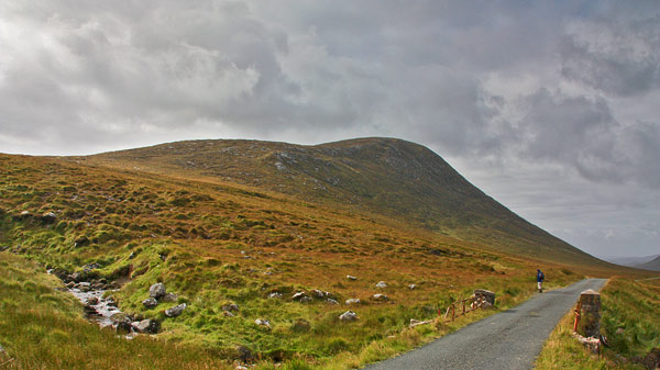
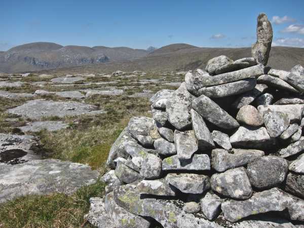
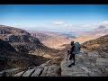
Picture: Moylenav from the North East.
There's impressive views of the ridge that includes Slieve Snaght and Dooish as well as Errigal and much of the rest of Donegal such as the Bluestacks from this summit.
One easy way to ascend is from the NE, starting at around Barra NE (B9616 1492) on the R254. There is a small battered bridge here and various places to park. Go SW to reach the summit, savouring the widening view as you ascend. The height gain is around 330m to the top and a round trip will take perhaps 90 minutes.
Another place to start is from the car park beside Lough Barra at A (B936 124). The route is approximately NE from here, requiring finding a place to cross the river Barra. This may not be possible after heavy rainfall.
Climbed 20.11.05, parking at layby next to Lough Barra (B (B936 124)) on the beautifully scenic R254. I followed a track on the other side of the road to the shore of Lough Barra and walked its sandy shore to the mouth of the River Barra, having to follow it inland to find a crossing point on one of its turns. There is some pretty wet ground to cross before the ground turns rockier as begin to climb. Even from here there are breathtaking views across the valley to Slieve Snaght and her companions. As gained height the line of the Bluestacks came into view behind Aghla Mountain, with the higher tops capped in cloud. There is a cairn at the top and the views extend to Errigal, Macknoght and the Aghlas - beyond the immediate and imposing line of hills from Dooish to Slieve Snaght. Head nearly due N for another small small cairn with views across the deep valley below which extends to the head of Glenveagh, with glimpes of the lake. Drop down NE along the steep face of Moylenanav where the ground is again pretty wet, can eventually drop off the hill to acess the road and follow it for 30 minutes back to the layby beside Lough Barra. I first saw this hill from across the valley on the Bingorms and it looked a good hill, it lived up to those thoughts and provided a few hours of walking along lough, river and hill, with stunning views on a fantastic day with clear blue skies - what more could you ask for? Linkback: mountainviews.ie/summit/377/comment/2066/
Read Less
Read More
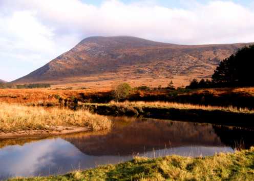
Picture: Errigal 7km to the NW.
Spectacular views.
by simon3
14 Sep 2010
Walking up the NE slope of Moylenav allows a succession of keyhole views through the Slieve Snaght - Dooish ridge. In this picture Errigal, particularly jagged from this angle, is seen through the gap between Crockfadda to the right and Drumnalifferny Mountain to the left. Linkback: mountainviews.ie/summit/377/comment/6094/
Read Less
Read More
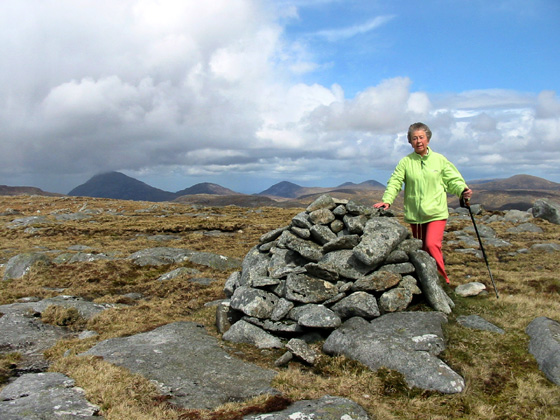
Picture: On Moylenanav summit. Donegal Highlands Errigal to Muckish on skyline.
Harry Goodman on Moylenanav
by Harry Goodman
24 Sep 2009
My wife and I climbed Moylenanav in April 2005. We started from the R254 at the back entrance to Glenveagh (MR C (B971 158)). We walked SW up the road for about 1k to a small bridge over a stream and turned left to initially follow up stream before heading SW up the shoulder of Moylenanav. There is a small cairn located at the N end of the summit plateau with fine views across to Slieve Snaght and through a gap in the ridge to Errigal. From here it was a short walk SE to the summit cairn at 539m. The views were extensive. To the SW Slieve League, Slievetooey and the long ridge of the Bluestacks were clearly visible. From the top we descended SE to a coll before climbing briefly to the broad flat top of Crockskallabagh, which is covered in peat hags and lacks a clearly identifiable summit. To avoid descending the steep and rocky NE slope we headed NNE in the direction of Meenbog Hill which we had intended to climb on our round. At the base of Crockskallabagh we found the going increaseingly marshy and decided to head NW to pick up the stream we had started at and walk down to the road. We turned right at the road and walked back to the car. We enjoyed this short but satisfyiny walk and would commend it to those looking for something different in the Derryveagh Mountains. From start to finish we encountered no fences or any other obstacles apart from wet and marshy ground on the walk back to the road. Linkback: mountainviews.ie/summit/377/comment/1778/
Read Less
Read More
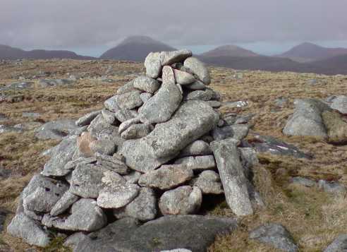
Picture: Moylenav's summit cairn with Errigal, Mackoght & Aghla Mór in background
eflanaga on Moylenanav
by eflanaga
30 Apr 2008
Approached Moylenav from Glendowan Beg area taking track (waterlogged in places) via minor top of Croaghnagapple, descending to head of Sruthangarrow and onto Croaghcullin & Crockscallabagh before short ascent to Moylenav's summit. Excellent views all around from Crockscallabagh onwards. Moylenav provides tantalising views of Bingorms sheer cliff-face & Sliabh Snacht across the R254. However, my route on the day took me down into the boggy valley leading to Meenabog Hill. One can't help but feel that the Anglicised name for this hill provides a better description of its topography than its true Irish meaning. I was glad to get off it and across the road to continue circuit via Farscallop & An Liathan Mór. Linkback: mountainviews.ie/summit/377/comment/3071/
Read Less
Read More
Picture: Moylenanav, Errigal & Slieve Snaght from Crockastoller
Summers here at last
by three5four0
23 May 2010
Climbed Moylenanav by the route described by Harry Goodman and a fine day it was too, the promissed sunshine had arrived along with temps in the mid twenties. The thought of dried out bog spurred us on to include Crockastoller in our circuit for the day. Hot and sunny it was, dried out bog it wasn't! See Glendowan Mountain Circuit in the walks section for the details. Linkback: mountainviews.ie/summit/377/comment/5817/
Use of MountainViews is governed by conditions and a privacy policy.
Read general information about the site. Opinions in material here are not necessarily endorsed by MountainViews.
Hillwalking is a risk sport. Information in comments, walks, shared GPS tracks or about starting places may
not be accurate for example as regards safety or access permission. You are responsible for your safety and your permission to walk.
See the credits and list definitions.


 Our Facebook page.