This website uses cookies, which are small text files that the website puts on your device to facilitate operation. Cookies help us provide a better service to you. They are used to track general user traffic information and to help the website function properly.
Feature count in area: 64, by county: Derry: 34, Tyrone: 39, of which 9 are in both Derry and Tyrone,
OSI/LPS Maps: 12, 13, 6, 7, 8
Highest Place: Sawel 678m
Starting Places (21) in area Sperrin Mountains: Altinure Road, Banagher Glen Nature Reserve, Barnes Gap Car Park, Crocknakin, Drumnaspar Picnic CP, Glenchiel Road, Glenedra Bridge, Glenelly Road, Parkreagh, Goles Road, Lough Ouske, Moneyneany Village, Moydamlaght Forest, Moydamlaght Road, Mullaghmore, Mullaghbane, Spaltindoagh, Sperrin Hamlet, Sperrin Heritage Centre, Sperrin Heritage Centre W, Sperrin Road, Barnes Top, Sperrin Road, Glashagh Bridge, Sperrin Road, Sperrin
Summits & other features in area Sperrin Mountains: E: Magherafelt Hills: Slieve Gallion NE Top 493.6m E: Magherafelt Hills: Slieve Gallion 526.6m N: Claudy Hills: Crockdooish 321m, Curradrolan Hill 270m, Eglish 277m, Letterlogher 249m, Mullaghmeash Hill 244m, Slieveboy 259m, Straid Hill 303m NE Cen: Glenelly North East: Barnes Top 456m, Craigagh Hill 460m, Crockbrack 526.1m, Knockanbane Mountain 441m, Meenard Mountain 620m, Meenard Mtn W Top 480m, Mullaghaneany 627m, Mullaghash 480m, Mullaghsallagh 485m, Oughtmore 569m, Spelhoagh 568m NE: Glenshane North: Benbradagh 465m, Boviel Top 454m, Carn Hill 448m, Carntogher 464m, Moneyoran Hill 414m NE: Glenshane South: Bohilbreaga 478m, Coolnasillagh Mountain 423m, Corick Mountain 430m, Crockalougha 407m, Mullaghmore 550m, White Mountain 537m NW Cen: Glenelly North West: Dart Mountain 619m, Dart Mountain North-West Top 525m, Learmount Mountain 489m, Learmount Mountain South Top 492m, Mullaghasturrakeen 581m, Mullaghcarbatagh 517m, Mullaghclogha 635m, Mullaghclogher 572m, Mullaghdoo 568m, Sawel 678m NW: Maheramason Hills: Clondermot Hill 220m, Gortmonly Hill 218m, Slievekirk 370m SE Cen: Glenelly South East: Carnanelly 562m, Carnanelly West Top 503.4m, Mullaghbane 467m, Mullaghturk 416m SE: Cookstown Hills: Cregganconroe 300m, Fir Mountain 362m, Oughtmore 382m SW Cen: Glenelly South West: Clogherny Top 408m, Craignamaddy 385m, Crocknamoghil 335m, Mullaghbolig 442m, Spaltindoagh 420m SW: Mullaghcarn: Curraghchosaly Mountain 416m, Mullaghcarn 542m, Mullaghcarn South Top 525m SW: Newtownstewart Hills: Bessy Bell 420m, Mullaghcroy 242m W: Strabane: Balix Hill 403m, Knockavoe 296m, Owenreagh Hill 400m
Note: this list of places may include island features such as summits, but not
islands as such.
Mullaghcarn, 542mMountain Mullach Cairn A name in Irish,
Place Rating ..
(Ir. Mullach Cairn [DUPN], 'summit of the cairn'), Tyrone County in Ulster province, in Arderin Lists, Mullaghcarn is the 440th highest place in Ireland.
Grid Reference H51054 80976,
OS 1:50k mapsheet 13 Place visited by: 131members, recently by: Matrim, garybuz, ronanmckee, FatPete, PrzemekPanczyk, Tricia-Mulligan, Lgr, abcd, dino, Sperrinwalker, Oscar-mckinney, Jai-mckinney, Cecil1976, AlanReid, Claybird007
I visited this place: NO (You need to be a logged-in member for this.)
Longitude: -7.209413, Latitude: 54.674295, Easting: 251054, Northing: 380976,
Prominence: 377m, Isolation: 0.9km, Has trig pillar
ITM: 650992 880970 Bedrock type: Psammite & semipellite, (Mullaghcarn Formation) Notes on name: No cairn now remaining, but the top of the hill is stony (OS Memoirs). Cairn Sunday is the last Sunday in July, and the old tradition of climbing Mullaghcarn on this day has recently been revived.
Short or GPS IDs, 6 char: Mlghcr, 10 char: Mulaghcarn Linkback: https://mountainviews.ie/summit/371/
Gallery for Mullaghcarn (Mullach Cairn) and surrounds
Summary
for Mullaghcarn (Mullach Cairn):
Easy and Well-walked Hill
Summary created by Peter Walker, Onzy
2015-03-06 21:03:48
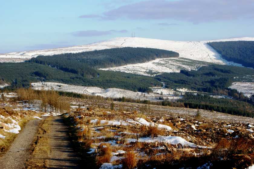
Picture: Mullaghcarn from Curraghchosaly Mountain to the NW
Mullaghcarn is an isolated peak north of Omagh on the B48 to Gortin situated in the popular Gortin Glen Forest Park. A number of signed walks are available in the Park. The summit itself has a number of masts and a trig pillar - however, its prominence means that the views from the top are stunning. The last Sunday in July is designated Cairn Sunday and the old tradition of climbing the hill on that day has been recently revived.
One of the upsides (or downsides) of masts, is that they are normally serviced by roads, and Mullaghcarn is no exception. The service road leaves the B48 at A (H494 830) and winds its steady way to the top, a distance of about 3km. Just over an hour should see you up and down.
There are other routes however, and the hill can be reached from the north, beginning at parking near Oak Lough, on the road heading east from the B48 at B (H494 842). There are a number of parking places along this road. A further route is available from the north east beginning in the townland of Lenagh.
Being a Tyrone man I have visited the Gortin Glens forest park many times but it was only yesterday (28/6/08) that I got round to climbing the mountain that I can see from my window, Mullaghcarn. I took the B48 out of Omagh towards Gortin and a few miles after the village of Gortnagarn I turned into the Forest park which is clearly signposted. I drove on in until I came to the car park but I continued straight through the carpark and out past the two cabins passing a few camping sites until I came to a T junction. I turned right for the 5 mile scenic route. After 2 or 3 miles up, passing a few picnic areas I dropped down into a sort of valley and when I looked at the OS map I realised that Pollen Burn ran down the centre of it. I drove another 150 metres up to the corner and parked the car here beside a small picnic area which is sheltered under the trees. It was here that I started my walk, around the iron gate and up a mucky lane which is nearly overgrown with weeds. I stayed on the lane until I went around a second gate and out onto a tarred road. I turned right up the hill into the shaddow of the trees for around 300 metres and then I rounded another corner were the road begins a steep climb up to a cattle grid were the top finally comes into view at the edge of the trees. From here you just follow the road up to the top to the masts. Over to the back is the trig point but before you get there there is a wet patch and you have to tred through using stones and planks of wood. From the top you can enjoy stunning views of the Sperrin Mountains and out as far as the eye can see to Monaghan and beyond. You should really consider going up on a clear day if you want to experince the true beauty of the scenery. I decended via the same route and continued on down the scenic route back out onto the Gortin Rd. Linkback: mountainviews.ie/summit/371/comment/3196/
Read Less
Read More
gerrym on Mullaghcarn
by gerrym
4 Oct 2004
I looked at the map for this one and tried to pick a route that would traverse the entire mountain. This was somewhat hit and miss but was an enjoyable day in the hills.From Gortin take B48 for Gortin Glen and turn off left on road signposted to Gortin Lakes. This is an fine area of glacial deposits and lakes with plenty of carparks. I parked at top of hill (C (H505 842)) with good views over Owenkillew River valley. Walk further along road and turn right onto track with steep banks which soon peters out onto pristine moorland. This is deep and tussocky ground which is bloody hard on the legs and lasts for 1/2 an hour, as aim for and follow ridge. Drop down slightly to edge of forest above little lough at head of altavakan Burn and then climb again on slightly easier ground - the sheep have been here and following thier faint tracks is like heaven after the previous slog. Pass little lough nestled among steep ground at the head of Magheraboy Burn and cross fence to join road with short steep climb to summit area aftre 1.5 hours. There are a number of rather unsightly communication masts here which were rattling in the strong wind. The small summit cairn and trig point are reached by a gravel path just off to the west. Good views from here to north and west to southern hills of Glenelly Valley and the higher Sperrins just to the north. Pass the masts and drop down SW along fenceline,passing a wet area to reach S summit which is just a little lower (see pic which is looking back to summit). Continue to descend SW along top of forest before a rise to the top of Slieveard (419m) with views over Omagh town. Drop further to enter edge of forest with easy walking among mature pine trees. Reach an area of recent clearfell not on map and descend downhill NE aiming for junction of Glengawna Burn and stream at edge of clearfell (D (H482 794)). Cross Burn to green grass on other side and follow to forest track, turn left and take second right to join Ulster Way. This uses a variety of tracks and paths through Gortin Forest Park, including a good section along Pollen Burn as bridges criss cross its lenght and then part of a nature trail. The Ulster Way then parallels the B48 before joining it. When reach turn to Gortin Lakes follow back to car. 5.5 hours in all. An information board for Cairn Sunday Walks (last Sunday in July)offers three walks. The easiest is a 3.5 km walk along tarmac road to summit. From the NE the approach is through Glenmacoffer along Magheraboy Burn and the third is from the west near Glencolpy Bridge.This is walking on varied terrain and can be as long or as short as you want. Linkback: mountainviews.ie/summit/371/comment/1220/
Read Less
Read More
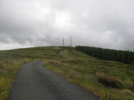
Picture: The western ridge of the Sperrins seen from Mullaghcarn
pdtempan on Mullaghcarn
by pdtempan
8 Sep 2008
On Wednesday 3rd September a group of 9 walkers climbed Mullaghcarn. The walk had a place-names theme and was part of the programme of the Peadar Joe Haughey Summer School, taking place over 3 days. After torrential rain on Tuesday and Wednesday morning, the skies cleared and the views were remarkably good. We began our walk from the board marking the start of the Cairn Sunday route situated in Lenagh townland, on the NE side of the mountain. Cairn Sunday is the last Sunday in July, and the old tradition of climbing Mullaghcarn on this day has recently been revived. The first hour of walking was through deep heather, but once we reached the ridge, there was a small but clear path which speeded our progress to the summit. From here we were able to see not only the Sperrins, but also Lough Neagh, Lough Erne, Errigal, Muckish, Slieve Donard and Ben Wiskin, which means our view more or less covered the whole width of the country. We made much faster progress on the descent, coming down the forest road on the NW side through the forest, meeting the main road at the pass between Gortin and Omagh (255m spot height). From here we were given a lift back to the cars at the starting point. The whole walk took 3½ hrs, though a good ½hr of this was taken up with stops for place-name discussion on the way up. Linkback: mountainviews.ie/summit/371/comment/3293/
Read Less
Read More
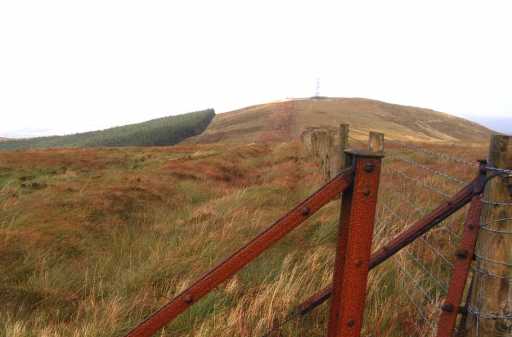
Picture: Walkers at the summit cairn of Mullaghcarn
pdtempan on Mullaghcarn
by pdtempan
8 Sep 2008
This photo by Denise Jacques shows the summit cairn which gives Mullach Cairn / Mullaghcarn its name and which is the objective of the Cairn Sunday walk on the last Sunday of July. Linkback: mountainviews.ie/summit/371/comment/3294/
Read Less
Read More
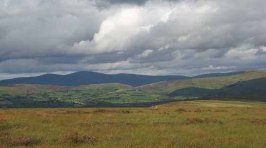
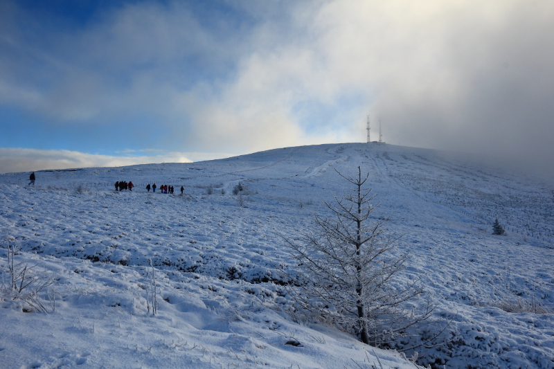
Picture: On a quest!
Climbed in great company on an auspicious occasion.
by Aidy
27 Dec 2014
I had a great day out on Mullaghcarn today, as it was chosen by Simoburn, as his final summit in an amazing completion of all the Vandeleur-Lynams and Arderins in one year. A group of MountainViews users, along with some of Simon's friends and relatives, turned up to accompany him on his walk to mark the achievement, and it was a privilege to do so. The mountain itself is not difficult, with a road all the way to the mast-crowned top, and was specifically chosen by Simon so that non-hill walkers would be able to come along. Well worth the climb on any occasion though, as the views are great, and we were lucky enough to get a winter wonderland and some dramatic clouds at the summit. Its the first time I have been presented with a beaker of champagne at the summit too, something to be recommended I feel!
The photo shows some of the group making their way to the cloudy top with Simon. Congratulations to you Simon for a great feat. I took plenty of photos, and I'll post a link here on MV, to a blog entry, when I get them all sorted. Linkback: mountainviews.ie/summit/371/comment/17773/
Use of MountainViews is governed by conditions and a privacy policy.
Read general information about the site. Opinions in material here are not necessarily endorsed by MountainViews.
Hillwalking is a risk sport. Information in comments, walks, shared GPS tracks or about starting places may
not be accurate for example as regards safety or access permission. You are responsible for your safety and your permission to walk.
See the credits and list definitions.


 Our Facebook page.