This website uses cookies, which are small text files that the website puts on your device to facilitate operation. Cookies help us provide a better service to you. They are used to track general user traffic information and to help the website function properly.
Feature count in area: 27, all in Antrim,
OSI/LPS Maps: 14, 15, 4, 5, 8, 9
Highest Place: Trostan 550m
Starting Places (3) in area Antrim Hills: Donalds Carn, Rathlin Island Ferry Port, Whitehead Golf Club
Summits & other features in area Antrim Hills: Cen: Central Antrim Hills: Carncormick 436m, Collin Top 429m, Crockalough 402m, Mid Hill 440m, Skerry Hill 459m, Slieveanorra 508m, Slievenahanaghan 418m, Soarns Hill 403m, Tievebulliagh 402m, Trostan 550m Central Antrim Hills: Slievenanee 543m N: North Antrim Hills: Carnanmore 379m, Croaghan 417m, Crockaneel 403m, Cross Slieve 206m, Knocklayd 514m, Lannimore Hill 207m N: Rathlin Island: Kilpatrick (Rathlin Island) 134m S: Islandmagee: Donalds Carn 141m, Muldersleigh Hill 131m S: South Antrim Hills: Agnew's Hill 474m, Big Collin 353m, Black Hill 381m, Carnearny 319m, Douglas Top 402m, Slemish 437.9m W: West Antrim: Long Mountain 215m
Note: this list of places may include island features such as summits, but not
islands as such.
Slievenanee, 543mMountain Sliabh na Nia A name in Irish,
Place Rating ..
(Ir. Sliabh na Nia [Buile Shuibhne*], 'mountain of the warriors'), Antrim County in Ulster province, in Arderin Lists, Slievenanee is the second highest mountain in the Antrim Hills area and the 439th highest in Ireland. Slievenanee is the second highest point in county Antrim.
Grid Reference D16679 21298,
OS 1:50k mapsheet 9 Place visited by: 123members, recently by: sprog, CianDavis, Moirabourke, PPruzina, mountainmike, NualaB, AlanReid, Arcticaurora, trostanite, Paddym99, Oscar-mckinney, Alanjm, garybuz, Cecil1976, chelman7
I visited this place: NO (You need to be a logged-in member for this.)
Longitude: -6.177156, Latitude: 55.026553, Easting: 316679, Northing: 421298,
Prominence: 98m, Isolation: 2.6km ITM: 716546 921409 Bedrock type: Olivine basalt lava, (Upper Basalt Formation) Notes on name: The name Sliabh Níadh is mentioned in Buile Shuibhne, the 12th century narrative known in English as The Frenzy of Suibne or The Madness of Sweeeny. Another line in Buile Shuibhne refers to Sliabh na nEach, 'mountain of the steeds', which may be a variant name for the same mountain, although this is further away from the modern anglicised form.
Short or GPS IDs, 6 char: Slvnn, 10 char: Slievenane Linkback: https://mountainviews.ie/summit/369/
Gallery for Slievenanee (Sliabh na Nia) and surrounds
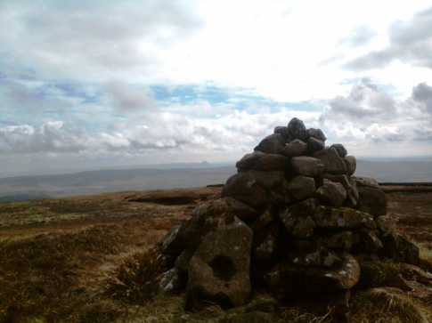
Picture: The summit cairn on Slievenanee with Slemish in the distance
slemish on Slievenanee
by slemish
19 Apr 2009
Somewhat overlooked by most hikers in favour of neighbouring Trostan, it should be remembered that Slievenanee is in fact the second highest mountain in Antrim. In order to avoid too much walking through boggy terrain I parked at the layby on the Orra scenic route between Newtowncrommelin and Cushendall (A (D154 216)). The road at this point reaches 415m and is one of the highest public roads in Northern Ireland, beaten only by the Park-Cranagh road in the Sperrins. Ascend the mountain from here keeping the fence to your left. Very boggy on the initial stages but the ground gets firmer as you go up. You will pass a small cairn on the approach to the summit area, which is vast - bigger even than Trostan's. Unlike Trostan however the bog hasn't eroded completely so care should be taken when exploring, which is required to fully appreciate the fabulous views: to Glenariff forest and glen, Mid Hill, Slemish, the Sperrins, Slieveanorra, Knocklayd, Rathlin island and the Scottish isles. The weather was fine, warm and surprisingly wind-free allowing me to spend a good 15 minutes on the summit - only last week on Trostan the wind was incredible. Contrary to what the other comments say there is in fact a small cairn marking the summit at an impressive 543m. I descended by the same route. A fairly straightforward climb and much less of a slog than Trostan. Total trip about 1 hour. Linkback: mountainviews.ie/summit/369/comment/3692/
Read Less
Read More
walker_hollick on Slievenanee
by walker_hollick
25 Jul 2004
A useful fence can be followed much (but not all) of the way from Trostan to Slievenanee. Leave the fence when it turns sharply to the right and head in a roughly south-westerly direction. You should pass a cairn shortly before reaching the summit area. From here you can head southeast to Agan Bridge (if you started out from Glenariff Forest). This avoids retracing your steps over very boggy terrain. Linkback: mountainviews.ie/summit/369/comment/1034/
Read Less
Read More
simon3 on Slievenanee
by simon3
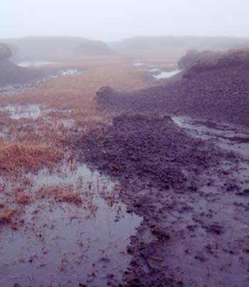
24 Apr 2004
If you were visiting you would probably summit Slievenanee immediately before or after Trostan, which means that you will walk the boggy land in between. Certainly the day that I was there this was comparable to one of the worst parts of Wicklow, with deeply cut, eroded bog and stretches of jelly-peat. Quite unlike Wicklow however is the pristine nature of the area. This is pure: natural vegetation alteration caused by climate change. The photo shows part of Slievenanee. At no point on it were there any signs whatever of footprints. Unlike Trostan, the summit does not have an area where the bog has completely eroded. Linkback: mountainviews.ie/summit/369/comment/941/
Read Less
Read More
simon3 on Slievenanee
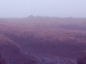
by simon3
24 Apr 2004
According to the GPS, the bumps visible in this picture were probably the highest point of Slievenanee. There was no other mark that we could find. A summit strictly for the purist. Linkback: mountainviews.ie/summit/369/comment/942/
Read Less
Read More
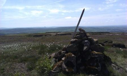
Picture: Cairn with Carncormick behind and Slemish the pimple in the distance
Summit?
by Welder
28 Jul 2013
Climbed up by the fence from the Old Cushendun Rd to a small cairn - but not the top. Drifted off NE to look for the top & eventually spied another, but not completely convinced it occupies the highest point. Mindful of the comments of others I chose a summer day after a dry spell and it was well worth it, I could just walk over the usually boggy summit. Linkback: mountainviews.ie/summit/369/comment/15052/
Use of MountainViews is governed by conditions and a privacy policy.
Read general information about the site. Opinions in material here are not necessarily endorsed by MountainViews.
Hillwalking is a risk sport. Information in comments, walks, shared GPS tracks or about starting places may
not be accurate for example as regards safety or access permission. You are responsible for your safety and your permission to walk.
See the credits and list definitions.


 Our Facebook page.