Cookies.
This website uses cookies, which are small text files that the website puts on your device to facilitate operation. Cookies help us provide a better service to you. They are used to track general user traffic information and to help the website function properly.
Features
Nearby features appear when you click the map.
Declutter tracks on map.
Place Search
Video
X
Pub: by
Antrim Hills Area , Cen: Central Antrim Hills Subarea
Feature count in area: 27, all in Antrim, OSI/LPS Maps: 14, 15, 4, 5, 8, 9
Highest Place: Trostan 550m

Starting Places (3) in area Antrim Hills:
Donalds Carn, Rathlin Island Ferry Port, Whitehead Golf Club

Summits & other features in area Antrim Hills:
Cen: Central Antrim Hills: Carncormick 436m, Collin Top 429m, Crockalough 402m, Mid Hill 440m, Skerry Hill 459m, Slieveanorra 508m, Slievenahanaghan 418m, Soarns Hill 403m, Tievebulliagh 402m, Trostan 550m
Central Antrim Hills: Slievenanee 543m
N: North Antrim Hills: Carnanmore 379m, Croaghan 417m, Crockaneel 403m, Cross Slieve 206m, Knocklayd 514m, Lannimore Hill 207m
N: Rathlin Island: Kilpatrick (Rathlin Island) 134m
S: Islandmagee: Donalds Carn 141m, Muldersleigh Hill 131m
S: South Antrim Hills: Agnew's Hill 474m, Big Collin 353m, Black Hill 381m, Carnearny 319m, Douglas Top 402m, Slemish 437.9m
W: West Antrim: Long Mountain 215m

Note: this list of places may include island features such as summits, but not islands as such.
Rating graphic.
Trostan, 550m Mountain Trostán A name in Irish,
Place Rating ..
(Ir. Trostán [DUPN], 'pole/staff' [DUPN]) County Highpoint of Antrim in Ulster province, in County Highpoint, Arderin Lists, Trostan is the highest mountain in the Antrim Hills area and the 421st highest in Ireland. Trostan is the highest point in county Antrim.
Grid Reference D17960 23598, OS 1:50k mapsheet 9
Place visited by: 393 members, recently by: rhw, purpleknight, discovering_dann, knightsonhikes, sprog, nolo, JordanF1, MarionP, Hikerjjl, edowling, ronanmckee, CianDavis, Padraigin, Moirabourke, DoloresMcmenamin
I visited this place: NO (You need to be a logged-in member for this.)
Longitude: -6.155396, Latitude: 55.045748, Easting: 317960, Northing: 423598, Prominence: 515m,  Isolation: 2.6km, Has trig pillar
ITM: 717881 923581
Bedrock type: Olivine basalt lava, (Upper Basalt Formation)
Notes on name: Joyce's suggestion (INP, iii, 586) that this peak is so named because of its resemblance to a pilgrim's staff with a crooked top seems without foundation.
  Short or GPS IDs, 6 char: Trstn, 10 char: Trostan

Linkback: https://mountainviews.ie/summit/361/
Gallery for Trostan (Trostán) and surrounds
Summary for Trostan (Trostán): Antrim's Highest
Summary created by Peter Walker, gerrym 2014-08-10 16:04:26
            MountainViews.ie picture about Trostan (<em>Trostán</em>)
Picture: Trostan (left) and Slievenanee from Knocklayd
Consensus suggests that Antrim's scenic wonders mostly lie on the coast and in the valleys, and Trostan bears this out. Its height is its only overt distinction, being otherwise a high plateau of varying degrees of saturation underfoot and assorted levels of peat erosion.

Consensus promotes the use of the waymarked Moyle Way to approach Trostan. From the south start from the small layby opposite the entrance to Glenarrif Forest Park (A (D201 207)) or at Essathohan Bridge (B (D190 217)). The Moyle Way can also be used from the west (start at (C (D157 238))) which is probably an easier ascent, but it is not as attractive -unless of course doing the whole Way!

The Way is well used and can be difficult in places, especially if wet. There is varied walking - through the forest, following the river and then open hillside. The Moyle Way is left as head north for the summit - a fenceline runs up over the broad flat summit area, not far from the cairn and trig pillar which stand high over the eroded landscape. Views can be far reaching and spectacular on a good day.

Antrim's second highest summit, Slievenanee, lies a bedraggled 2.5km to the SSW.
Linkback: mountainviews.ie/summit/361/comment/5120/
Member Comments for Trostan (Trostán)
Comment create / edit display placeholder

            MountainViews.ie picture about Trostan (<em>Trostán</em>)
Picture: View of Tievebulliagh from the track
Longer but More Scenic and Enjoyable Approach
by dr_banuska 20 Oct 2016
This was my 4th visit to Trostan: 1st was via neighbouring Slievenanee and 2nd and 3rd were via the perpetually wet Moyle Way/Ulster Way approach to the west. On the 3rd visit we did the entire MW over 2 days and came down Trostan via the hellish 'route' through part of Glenariff Forest Park to the SE of the mountain.

This time we chose a new route I'd spotted on the map after the last time. This involved following a track which arcs around the E and N of the mountain. We parked at a small lay-by on the B14 road at D (D193 220) then walked NE to the forest edge on our left. We crossed a fence with a handy plastic tube then followed the line of the forest a short distance to reach the track, which is more a grassy path. From here we followed the track NE until it split then followed the main spur which passes under a line of cliffs on Trostan's eastern slopes.

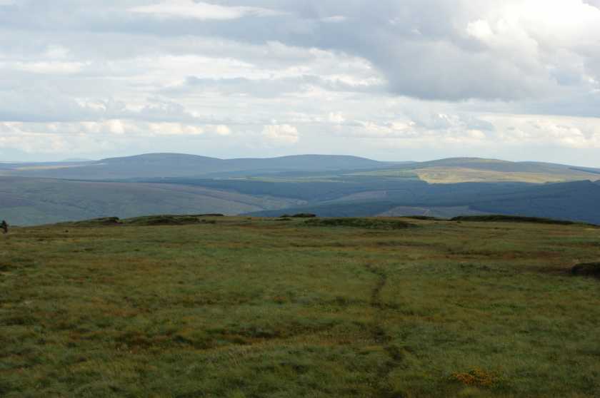
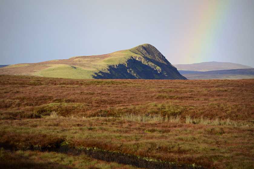
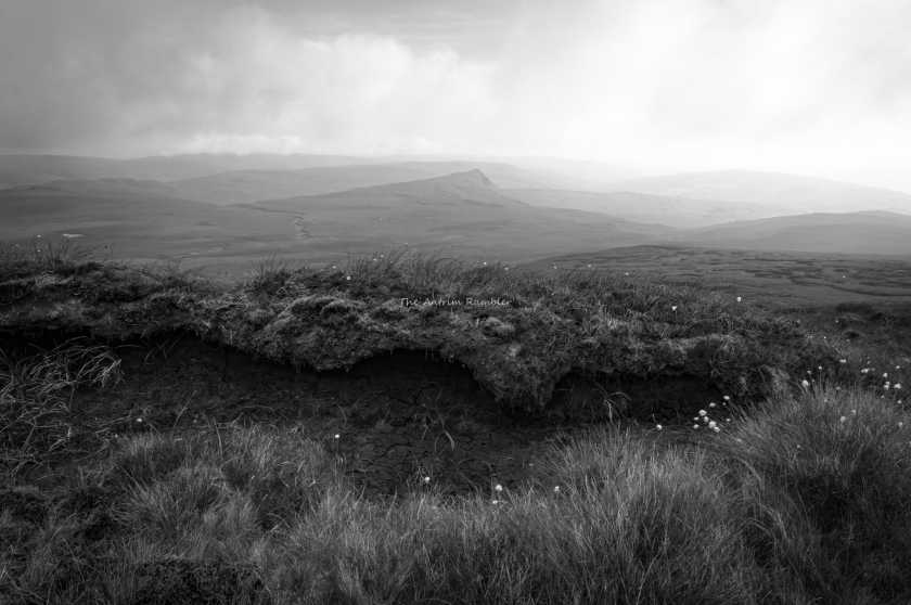
This route is delightful, with a gentle incline and fine views of the the cliffs above and of the surrounding hills and out to sea. The steep eastern face of nearby Tievebulliagh rose from the surrounding bog, with a rainbow to the right. The route passes a large grassy mound which you can walk up, as well as several waterfalls. The evening sun was almost blinding as we rounded the northern slopes and walked the last section of the track, which ends at a fence running from Trostan to Tievebulliagh (
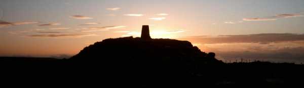
E (D182 244)). From here it's a wet enough slog to the summit trig, but definitely not as bad as the MW route. The evening light was stunning on Trostan's barren, reddish top and views included south to Slemish, the Belfast Hills and Lough Neagh, west as far as Inishowen and north across Rathlin Island to Islay. The cliffs of the Mull of Kintyre came in and out of focus.

As light was fading we chose to take a more direct route down by heading parallel to the forest edge. The terrain was fine at first but got tougher near the bottom. We entered the northeastern offshoot of the forest by climbing under a fence over a stream (F (D191 223)) but felling had taken place here and the ground was very wet and uneven. We eventually reached the road by climbing the fence next to a bridge, with the car just a short distance to our right. Ideally we should have avoided the forest altogether and if we'd had more time could have aimed for the track again, while not following its entire route.

Overall though this was a very enjoyable hike which gave a totally new perspective on Trostan. I'd definitely recommend using the track if you have time. Our entire loop was still only 6.9kms.

I've written a blog post on the route if you'd like to see more photos: https://hikecycleireland.wordpress.com/2016/10/18/trostan-a-longer-but-more-enjoyable-approach/ Linkback: mountainviews.ie/summit/361/comment/18661/
Read Less
Read More

            MountainViews.ie picture about Trostan (<em>Trostán</em>)
Sanctuary
by AntrimRambler 27 Feb 2018
County Antrim’s highest may not have the might or distinction of some of the highest in the other counties but it has a great quality. It is rarely visited. In my 17 years of visits I have only ever seen another person once and that was when I had been on its northern slopes for 13 hours after camping overnight. On nearly every other Antrim Hill I have met lots of folk but not on this blessing. This near promise of peace is what draws me back again and again. I adore the place. Windmills on the horizon are minimal. The variety in approaches are good, the views are wonderful in most directions with it’s southern vistas in particular being very photogenic and the lunar landscape of the summit is such a unique feature that is worth the visit all by itself. So what is my best route? The apparent pattern to my routes of ascent of all hills seems to be the ones that disguise the best views until the last minute and while that is difficult in this instance this route has the bonus of including its neighbour Slievenanee. As with all good routes in the Antrim Hills I would advise you to have cars at both ends as the landscape doesn’t help create great long, circular routes without too much road walking. It is made for multiple lines from inland valley or forest to the coast. When done this way a lifetime of walks become obvious. Leave one car in Glenariff Forest Park car park and the other near the shed on the Altrichard Road NG (W31278 78280) while not obstructing any access and then turn onto the Old Cushendun Road and walk a few hundred yards to you can see the fence going up the mountain on your right NH (W31923 78457) Simply follow its right side up to the fence junction, cross it and then make your way across to the summit NI (W33039 78103). When you have had your fill of the view make your way north east across the boggy gap and up to Trostan NJ (W34666 80265). This approach hides the views that await on the northern edges of the summit plateau but when you do reach it they will take your breath away. Tievebulliagh with its pointy profile is dominant to the north and you have the bulk of Slieveanorra to the west and Lurig and the coast to the east. This is a wondrous view that takes a long time to study and get your fill of so allow plenty of time to do so. When you have seen everything you want to it’s time for the best route of descent. On the mountain’s eastern side there is a large ledge. If you descend on to it then turn southwards eventually it will lead you to the Ballyeamon Road NK (W35464 80105) This descent allows you to complete your picture of the mountain and it’s place in the landscape while at the same time giving great views over to Lurig, the coast and the bog on its lower slopes. When you finally reach it, cross the road and use the last entrance to enter Glenariff Forest NL (W36184 79021) This track leads you down to the main entrance on the Glenariffe Road where you can make your way to your car in the Forest Park NM (W37491 76701) Enjoy :-) Linkback: mountainviews.ie/summit/361/comment/19862/
Read Less
Read More

            MountainViews.ie picture about Trostan (<em>Trostán</em>)
Picture: Close to Trostan summit, an unusual collection of stones
Our final CHP
by paddyobpc 25 Jan 2017
Walk Date: 11 Sep 2016. We set off for Belfast on Sunday morning with the intention of completing our final CHP walk on Monday 12th but as the weather was so good on the journey up we decided to go ahead and do the walk on the 11th instead. Both Dillon(dillonkdy) and myself were excited that the time had finally arrived, time to complete our last County of The County High Point Challenge. Once again we stuck with the route described by Kieron Gribbon’s book “Ireland's County High Points – A Walking Guide” and parking at the start point on the old Cushendun road just after 1:30 there was a handy breeze blowing as we put on our gear. The majority of the walk is over boggy ground and probably a lot worse in winter months. From our start point we only had to climb 215m to a very windy summit, a return journey to the car of just over 6 Km which we completed in 2 hours. So that was the final one complete, at the age of 9, Dillon(dillonkdy) could now say he was the youngest to have completed the County High Point Challenge.
See Dillon’s (dillonkdy) full story of his County High Point Challenge at https://dillons32chpchallenge.github.io/progress/index.html We also found Kieron Gribbon's High Point Ireland website (www.highpointireland.com) to be a useful source of information for our 32 County High Points challenge. Definitely worth checking out if you're planning to do any of the High Point challenges. Linkback: mountainviews.ie/summit/361/comment/18829/
Read Less
Read More

            MountainViews.ie picture about Trostan (<em>Trostán</em>)
Picture: Looking north-east from Trostan summit towards Lurigethan
slemish on Trostan
by slemish 27 Mar 2009
This was only my second time climbing Antrim's highest mountain and I would agree with the other comments - expect boggy wetness and plenty of it. Wellies an absolute must - even then I sank into the bog over knee height a couple of times. I parked at the Essathohan bridge and followed the Moyle way up as far as the lovely waterfall. Forget using the Moyle way through the rest of the forest - it's just too boggy. Turn right after the waterfall through the firebreak until you come to the edge of the forest. Then turn left and go straight up the hill, keeping the fence on your left until near the summit where you veer off right. The summit area is large and thankfully, devoid of peat. The sun came out just as I was approaching the large cairn and trig pillar on the summit at 550m, allowing fine views to the north-east. The village of Cushendall framed by the dramatic slopes of Lurigethan and Tievebulliagh was a breathtaking sight, Kintyre just about visible on the horizon. Good views also to Slemish, Slievenanee, Slieveanorra and Knocklayd. I was surprised to see large volumes of snow and ice still on the summit. It was incredibly windy and bitingly cold so I quickly descended by the same route. A bit of a slog to be honest but a true wilderness experience. Total trip about 1.5 hours. Linkback: mountainviews.ie/summit/361/comment/3682/
Read Less
Read More

            MountainViews.ie picture about Trostan (<em>Trostán</em>)
Picture: summit cairn and trig at sunset
Monarch of the Glens
by gerrym 8 Nov 2010
The Antrim Hills are my locals but I have only climbed Trostan twice in my years of walking. To be honest i feel there are better areas to explore locally such as Fair and Torr Heads, Lurigethan or the steep sided hills heading seaward from Glenariff to Cairn Neill (I think this is the best walk in the Antrim Hills and have done it countless times over the years). Trostan is the highest hill hereabouts and it does have a few saving graces.

There are relatively easy approaches from either the SE or W, following the path of the waymarked Moyle Way which passes close to the summit. There is not a great deal of satisfaction to be had unless the walk is lengthened, fortunately there are excellent opportunities to do this. I would not reccomend taking in neighbouring Slievenanee (unless you are ticking it off) - my memories are of wet and more wet, floating bog, frost and darkness - balanced against the light of Rathlin Island lighthouse sweeping over the hills and a meteor streaking through the cold night sky.
The best approach is probably from Glenariff, following the Moyle Way from the S, through the forest onto the open hillside and then veering off for the top.

The summit area of Trostan is in marked contrast to the approaches - a barren landscape of stone and rock, with a trig pillar held aloft from the eroded ground around. The summit area is extensive and a walk around will enable full appreciation of the fantastic views. To the E the Irish Sea meets the Mull of Kintyre and N the steep cliffs of Rathlin Island are backed by the Scottish islands of Islay and Jura (with the impressive Paps clearly visible on a good day). The other significant hills of Knocklayd, Slieveanorra and Slievenanee are all visible. Further away the Belfast Hills and the length of the Sperrin Hills are also visible.

I would recommend dropping off Trostan to the E as there is a significant area of steep rocky bluffs which would not normally be seen if using the Moyle Way routes. The Antrim Hills and Glens may not be that high but there is a great variety for the walker and some really impressive scenery created the last time we had glaciers for company. Linkback: mountainviews.ie/summit/361/comment/829/
Read Less
Read More
EDIT Point of Interest
text
Videos


Recent Contributions
x
Conditions and Info
Use of MountainViews is governed by conditions and a privacy policy.
Read general information about the site.
Opinions in material here are not necessarily endorsed by MountainViews.
Hillwalking is a risk sport. Information in comments, walks, shared GPS tracks or about starting places may not be accurate for example as regards safety or access permission. You are responsible for your safety and your permission to walk.
See the credits and list definitions.

OSi logo
OSNI/LPS logo
Open Street Map
(Various variations used.)
British summit data courtesy:
Database of British & Irish Hills