Cookies.
This website uses cookies, which are small text files that the website puts on your device to facilitate operation. Cookies help us provide a better service to you. They are used to track general user traffic information and to help the website function properly.
Features
Nearby features appear when you click the map.
Declutter tracks on map.
Place Search
Video
X
Pub: by
Central Dingle Area , Cen: Dromavally Subarea
Feature count in area: 25, all in Kerry, OSI/LPS Maps: 70, 71, 78, EW-DC, EW-DE, EW-DW
Highest Place: Beenoskee 826m

Starting Places (34) in area Central Dingle:
Anascaul Village, Annascaul Lake, Ballyduff Grave Yard, Brandon Village, Cloghane Community Centre, Conor Pass, Doonore South, Doorah, Dromavally Mountain SE, Emlagh Cross, Emlagh Wood, Farrannakilla School, Glan Mountain, Glanteenassig Lane, Glanteenassig Wood CP, Glennahoo River, Hostel Cloghane Village, Killiney R560 Junction, Kilmore Lodge, Lios Pole Church, Lisduff Rath, Lough Camclaun, Lough Caum, Lough Doon CP, Lougher, Maum Cross, Maumnahaltora Cross, Minard Beach, Mullaghveal Farm, Owenascaul Estuary, Pedlars Lodge, Pilgrimage Trail Owenmore River, Sauce Creek Walkway Dingle Way, Teerbrin

Summits & other features in area Central Dingle:
Cen: Annascaul Lake West: Cnoc na Bánóige 641.6m, Cnoc na Bánóige North Top 447.6m, Knockmulanane 593.2m, Knockmulanane West Top 563.5m
Cen: Dromavally: Cummeen 477m, Dromavally Mountain 552m, Knocknakilton 423m
N: Annascaul Lake North: Coombane 610m, Beenatoor 592m, Beenoskee 826m, Stradbally Mountain 798m
N: Carrigdav: Carrigadav 240m
N: Fermoyle: Farrandalouge 144m
S: Annascaul: Beenmore 252m, Brickany 374m, Knockafeehane 301m, Knocknanacree 286m
W: Ballyduff: Slievenalecka 458.4m, Beenbo 476.7m, Slievenagower 485.8m
W: Slieveanea: An Cnapán Mór 649m, Knockmoylemore 493m, Croaghskearda 608m, Slievanea 628.7m, Slievanea NE Top 670.7m

Note: this list of places may include island features such as summits, but not islands as such.
Rating graphic.
Dromavally Mountain, 552m Mountain Cnoc Dhrom an Bhaile A name in Irish,
Place Rating ..
(Ir. Cnoc Dhroim an Bhaile [TCCD*], 'hill of Dromavally'), Crucknamullin, Kerry County in Munster province, in Arderin Lists, Dromavally Mountain is the 417th highest place in Ireland.
Grid Reference Q60622 06650, OS 1:50k mapsheet 71
Place visited by: 75 members, recently by: maoris, chelman7, muddyboots, Moses, annem, mh400nt, Ulsterpooka, Sweeney, eoghancarton, learykid, jgdarcy, Fergalh, InTheFade, peter1, mountainmike
I visited this place: NO (You need to be a logged-in member for this.)
Longitude: -10.039029, Latitude: 52.194525, Easting: 60622, Northing: 106650, Prominence: 206m,  Isolation: 2.6km
ITM: 460603 606708
Bedrock type: Purple cross-bedded sandstone, (Cappagh Sandstone Formation)
Notes on name: Three cairns on the summit ridge of Dromavally Mountain are named Cú Chulainn's House, Cú Chulainn's Bed and Cú Chulainn's Grave. It is intriguing that there are several folk-tales about Cú Chulainn recorded on the Dingle Peninsula, far away from his home area in Cooley and SE Ulster. See Knockmulanane for the legend concerning Scál Ní Mhurnáin, Cú Chulainn and the giant. Previously Reamore in MV.
  Short or GPS IDs, 6 char: DrmvMn, 10 char: DrmvlyMntn

Linkback: https://mountainviews.ie/summit/355/
Gallery for Dromavally Mountain (Cnoc Dhrom an Bhaile) and surrounds
Summary for Dromavally Mountain (Cnoc Dhrom an Bhaile): Large bump on ridge surrounded by five different valleys
Summary created by simon3, Colin Murphy 2020-01-20 07:50:47
            MountainViews.ie picture about Dromavally Mountain (<em>Cnoc Dhrom an Bhaile</em>)
Picture: View from south west.
A southern start is at DrmVal Mtn (Q614 053), where there are a number of houses and space to park by the side of the road. You will see a track behind an iron gate leading north, beside a farmhouse. A friendly, elderly farmer who owns the land has previously had no objection to walkers, but it might be as well to ask his permission before using the track just as a courtesy. Follow this track as it meanders up the hillside, taking you to about 250m, where it ends in a farm structure. Continue NW up the hillside for about 1.25km, the terrain becoming increasingly steep, consisting of grass and heather, but mostly firm underfoot. The summit is marked by a large cairn.
A northern start is from L Caum (Q5998 0784) however this has some difficult ground.
Linkback: mountainviews.ie/summit/355/comment/5115/
Member Comments for Dromavally Mountain (Cnoc Dhrom an Bhaile)
Comment create / edit display placeholder

            MountainViews.ie picture about Dromavally Mountain (<em>Cnoc Dhrom an Bhaile</em>)
Picture: Lough Anascaul
jackill on Dromavally Mountain
by jackill 6 Sep 2006
Coming out from Tralee I took the road to Camp.
The Milesians who came originally from Egypt, settled in Spain, and invaded Ireland in 1700 BC fought their first battle in the mountains near Camp.
The Tuatha Dé Danainn – the ruling tribe of Ireland at that time – opposed them.
Their Queen Scota and another Milesian princess Fais were among the slain.
Scota is buried on the mountainside in view of Tralee Bay at a place called Glenscoheen (Scota's Glenn).
The Milesians won the battle and the war for the conquest of Ireland.
The Kings and Queens of the Tuatha Dé Danainn were killed and legend has it their people were driven underground into forts and mounds where they became the fairies.
From Camp I carried on to Anascaul ,the giant Cu Chulainn is said to have lived in this area.
The ruins of his house and castle are said to be the cairn A (Q590 062) in the mountains above Anascaul lake on the way to Reamore.
It was from Anascaul lake that I began my walk.
From Anascaul I took the first road to the left after The South Pole Inn and followed the signs for the lake.This road leads to the lake shore where there is room to park six or so cars B (Q583 052). I followed the track along the side of Garrivagh river which passes over three small bridges before gaining the plateau at approx 370 meters.
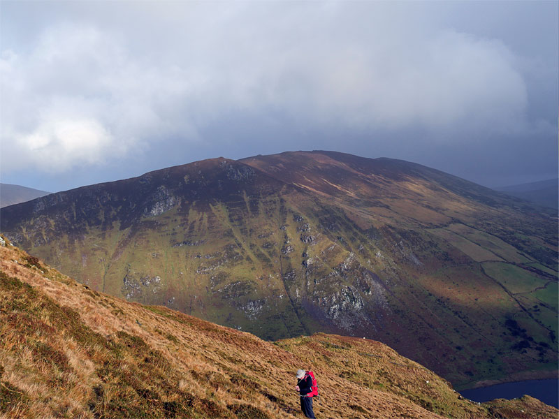
From the track end I headed for Beenoskee passing some rocky,Old Red Sandstone outcrops on generally good ground with some easily avoided patchs of bog.
As I neared the summit mats of Crowberry with pink flowers just beginning to appear were abundant.
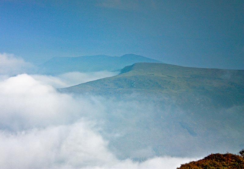
On the rock strewn summit of Beenoskee I sat in the mist behind a small cairn for my lunch, the only views to speak of were of Loch an Choimin some 200 meters below and the rainclouds approching from the west over the Connor pass.
Thankfully the threatening rain did not fall and by the time I reached Stradbally Mountain and turned around to head for Coumbaun the murky morning had given way to glorious afternoon.
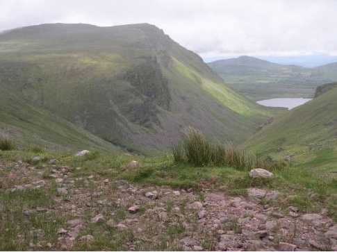
From Coumbanes grassy summit I carried on to another at Beenatoor.These are small hills when approached from this plateau but what excellent views over Brandon Bay.
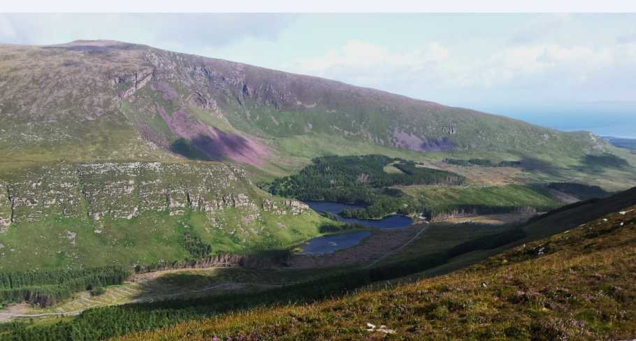
I skirted around the source of the Mhacha na Bo river and back towards the track to Loch Anascaul in brilliant sunshine.
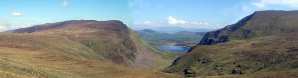
The photo was taken on the way down with Dromavally Mountain on the left, Knockmulane on the right and Loch Anascaul below in the center . Linkback: mountainviews.ie/summit/355/comment/2349/
Read Less
Read More

            MountainViews.ie picture about Dromavally Mountain (<em>Cnoc Dhrom an Bhaile</em>)
pdtempan on Dromavally Mountain
by pdtempan 23 Nov 2003
The most distinctive features of this mountain are the three ancient cairns on the summit ridge known as Cú Chulainn's House, Cú Chulainn's Bed and Cú Chulainn's Grave. In this view, it is the mountain to the left. Anascaul Lake is seen below. Linkback: mountainviews.ie/summit/355/comment/757/
Read Less
Read More

            MountainViews.ie picture about Dromavally Mountain (<em>Cnoc Dhrom an Bhaile</em>)
Picture: South from Dromavally
Looking South
by CaptainVertigo 23 Aug 2014
See Track 2630: The ascent from the Coillte inner car park at L Caum (Q5998 0784), which is circa 210m in height, to the summit at 552m, is difficult enough, initially along a fence between newly planted and felled forest, and then on steep grassy slopes, gradually softening as height is gained.(The OS Map suggests trees to the summit: not true, only on a minor belt of the lower slopes) Gaining the summit is really the main work of the day over: the rest is pure hillwalking heroin. From here I walked southwest along the broad spine taking in the unobstructed views of Iveragh across Dingle Bay to my left (see attached photo) and the prettiness of the steep sided valley on my right. A real thrill came as I contoured towards the head of the valley, descending gradually along the edge of the cliffs and seeing constantly changing views of the pocket. A river tumbles over the head ( C (Q5880 0714) ) through soft ground and offers an escape route to the forest road below if required. I continued around the cliff horseshoe, until I was on the very steep ground over the Loch Cam, and contoured until I found a gully safe enough to descend at D (Q59362 07887). Circling the lake was a simple matter as Coillte have erected a boardwalk the whole way around.
You'll need Coillte permission to attempt the above route from The Inner Carpark. A simple way around this problem would be to park at E (Q6084 0805) and head south between the cliffs and Lough Slat and gain the summit from there. Linkback: mountainviews.ie/summit/355/comment/17633/
Read Less
Read More

            MountainViews.ie picture about Dromavally Mountain (<em>Cnoc Dhrom an Bhaile</em>)
Picture: Dromavally from the north, with Brickany backdrop.
Misty view from the North.
by simon3 28 Jul 2014
Here is a misty view of the summit from the NW on the ridge that extends East of Stradbally Mountain.
The murky skyline of this picture has the small summit of Brickany in it.
The picture makes Brickany look higher than Dromavally however the true relationships in the picture are something like this.

Camera on flank of Stradbally around 660m : Dromavally 552m : Brickany 374m

On a clearer day it would be obvious because the land behind Brickany (Inch Strand) would be visible. Linkback: mountainviews.ie/summit/355/comment/17572/
Read Less
Read More

            MountainViews.ie picture about Dromavally Mountain (<em>Cnoc Dhrom an Bhaile</em>)
Picture: View North from Dromavally
Giving Huge Rewards!
by CaptainVertigo 23 Aug 2014
Dromavally Mountain is a modest 552m, and is overshadowed by larger neighbours, but it offers great rewards for relatively small effort. It benefits from a broad ridge which offers magnificent views in all directions. The photo shows the view to the north from Dromavally, across the beautiful Glanteenassig, to Stradbally. It is an area of forests, lakes, cliffs and scree. Well worth a walk. Linkback: mountainviews.ie/summit/355/comment/17632/
Read Less
Read More
EDIT Point of Interest
text
Videos


Recent Contributions
x
Conditions and Info
Use of MountainViews is governed by conditions and a privacy policy.
Read general information about the site.
Opinions in material here are not necessarily endorsed by MountainViews.
Hillwalking is a risk sport. Information in comments, walks, shared GPS tracks or about starting places may not be accurate for example as regards safety or access permission. You are responsible for your safety and your permission to walk.
See the credits and list definitions.

OSi logo
OSNI/LPS logo
Open Street Map
(Various variations used.)
British summit data courtesy:
Database of British & Irish Hills