This website uses cookies, which are small text files that the website puts on your device to facilitate operation. Cookies help us provide a better service to you. They are used to track general user traffic information and to help the website function properly.
Feature count in area: 28, all in Kerry,
OSI/LPS Maps: 78, 79, EW-KNP, EW-R
Highest Place: Mangerton 838.2m
Starting Places (30) in area Mangerton: Cummeenboy Stream, Derrycunihy Church, Dunkerron Mid, Garries Bridge, Gowlane School Ruin, Hidden Valley Pet Farm, Inchimore West, Kenmare Bridge, Killarney Hiking Parking Lot, Knockanaskill N, Knocknsallagh Bridge, Loo River Junction, Looscaunagh Lough W, Lough Barfinnihy CP, Lough Guitane E, Lough Guitane SE, Lough Guitane W, Lynes Farm, Mangerton Walk N CP, Mangerton Walk Start, Molls Gap, Muckross Lake S, Old Rail Level Crossing, Poulacapple, River Roughty, Rossacroo na Loo Forest, Sahaleen Bridge, Shaking Rock W, Shronaboy Farm MTB, Torc Waterfall CP
Summits & other features in area Mangerton: Cen: Dromderlough: Dromderalough 650m, Dromderalough NE Top 654m, Dromderalough NW Top 625m, Knockbrack 610m, Knockrower 554m, Shaking Rock 402m Cen: Inchimore: Inchimore 256m Cen: Mangerton: Glencappul Top 700m, Mangerton 838.2m, Mangerton North Top 782m, Stoompa 705m, Stoompa East Top 608m NE: Crohane: Bennaunmore 454m, Carrigawaddra 425m, Crohane 650m, Crohane SW Top 477m NW: Torc: Cromaglan Mountain 371m, Torc Mountain 534.8m, Torc Mountain West Top 479.4m SE: Esknabrock: Esknabrock 406m SW: Peakeens: Derrygarriff 492m, Derrygarriff West Top 382m, Foardal 409.8m, Knockanaguish 509m, Peakeen Mountain 554.7m, Peakeen Mountain Far NW Top 525.5m, Peakeen Mountain North-West Top 522.7m, Peakeen Mountain West Top 538.7m
Note: this list of places may include island features such as summits, but not
islands as such.
Knockrower, 554mMountain Cnoc Ramhar A name in Irish,
Place Rating ..
(prob. Ir. Cnoc Ramhar [PDT], 'fat hill'), Kerry County in Munster province, in Arderin Lists, Knockrower is the 410th highest place in Ireland.
Grid Reference V93747 78454,
OS 1:50k mapsheet 78 Place visited by: 68members, recently by: maoris, garrettd, Krzysztof_K, peter1, SmirkyQuill, Ulsterpooka, Taisce, chelman7, annem, upper, Fergalh, obanboy, mountainmike, Grumbler, millsd1
I visited this place: NO (You need to be a logged-in member for this.)
Longitude: -9.546101, Latitude: 51.948545, Easting: 93747, Northing: 78454,
Prominence: 59m, Isolation: 1.3km ITM: 493717 578512 Bedrock type: Green sandstone & purple siltstone, (Glenflesk Chloritic Sandstone Formation) Notes on name: Named Péicín on the Discovery map, but this seems an error.
Short or GPS IDs, 6 char: Knckrw, 10 char: Knockrower Linkback: https://mountainviews.ie/summit/354/
Gallery for Knockrower (Cnoc Ramhar) and surrounds
Summary
for Knockrower (Cnoc Ramhar):
Good approach from the west
Summary created by Colin Murphy
2015-04-23 18:57:38
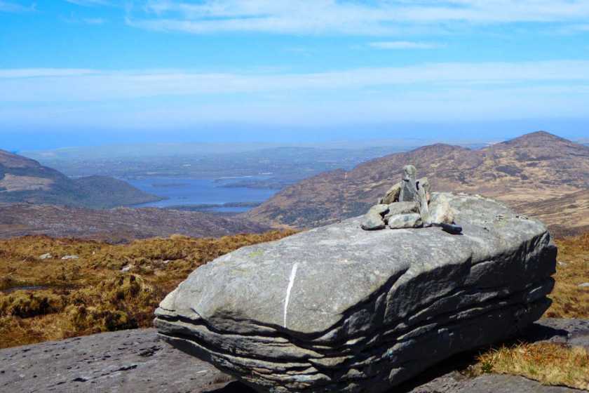
Picture: Summit boulder with Lough Leane in distance, Torc Mt on Right
Take road directly north from Kenmare (following Kerry Way). Note: after 1km main road swings NW, but take the fork to the right and continue for 4km until you come to a T-junction, with the Kerry Way a track directly ahead. Turn right here and continue for 1km until the road ends in a farm. You will see a sort of fork, with the left option blocked by a gate leading to a building, and the right option leading into a farmyard. Parking for a couple of cars here. (Point A (V925 758)) The friendly lady of the farmhouse was happy to allow access to the substantial track to the north. From parking spot, taking the fork to the left, cross the gate and walk beyond the building where you will immediately see a well-formed track. Follow this for just over 1km where it deteriorates to a rougher track that is quite muddy in places but well defined. After another 1km, Knockrower will be obvious to the NE (assuming weather is clear.) just 1.5km away. (Point B (V927 780)). Leave the track and head east across open country - the initial stages are a gentle slope but a little boggy underfoot, even after prolonged dry spell. Terrain improves at elevation of 400m where slope becomes steeper, a mixture of short grass and rocks, but easily navigable. Continue NW for another 500m to attain summit - a large rocky outcrop topped by a single large boulder, itself topped by a pile of stones marking high point. From car to summit allow 1 hour 15 minutes.
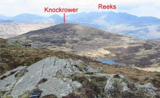
Just a photo to put Knockrower in perspective. It is a well defined peak which is just West of Mangerton. The photo shows the view looking accross from Knockbrack. In the background are the Reeks with the highest summits in Ireland. Linkback: mountainviews.ie/summit/354/comment/2304/
Read Less
Read More
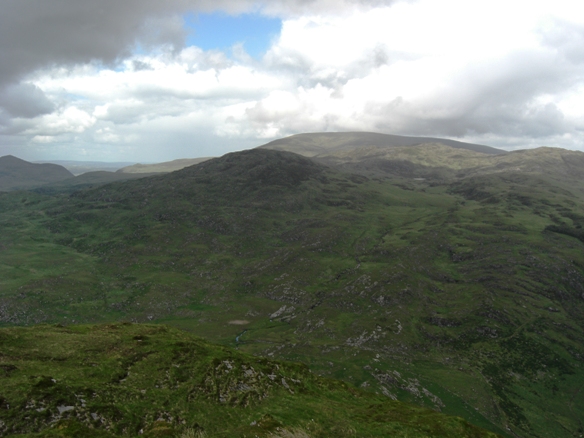
Picture: Knockrower from Knockanaguish, Mangerton behind, Knockbrack and Dromderalough to the right
dbloke on Knockrower
by dbloke
16 Jun 2009
Knockrower offers plenty of choice of route from the old green road to the W. The slopes are grassy and gentle and
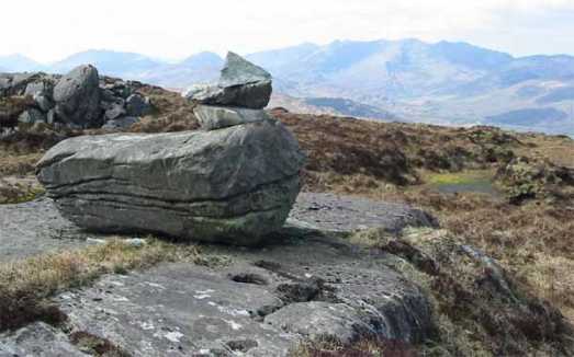
Picture: Glacial rock on the summit with a few more recent additions on top of it
john_desmond on Knockrower
by john_desmond
26 Apr 2006
I approached Knockrower from the South-East , skirting around East of Lough Nambrackdarrig after coming down off Knockbrack. It is slow going and adds a lot onto a walk if you decide to do it from this side and detour from Knockbrack on the way to Dromderalough. It might be better to include it as part of a loop walk from the Old Kenmare road in the valley to the West. The summit itself is unusual in that it is a large boulder lying on a rocky outcrop. It looks too large to have been deliberately placed there so I presume that it was dropped there by the last glacier as it melted 9,000 years ago. The views over the old Kenmare road are a bit bleak although there are some nice views in the distance of the Reeks and the mountains of South Kerry. To the North-East, the huge expanse of Mangerton dominates the skyline. Linkback: mountainviews.ie/summit/354/comment/2303/
Read Less
Read More
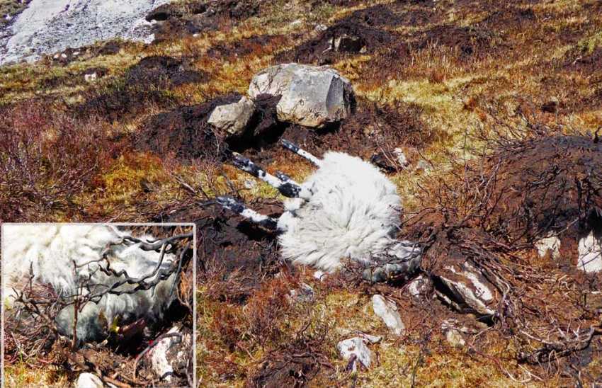
Picture: The stiff, with inset, blood from the fatal blow, but what was the motive???
The mystery of the dead sheep
by Colin Murphy
24 Apr 2015
Trudging head down towards the summit, I literally almost fell over a dead sheep. What was strange was the fact that it seemed to have died in the last few hours and I couldn't figure out how. Rigor mortis had set in (as evidenced by the sheep's stiffly and horizontally protruding legs and there was a fresh pool of blood under its head (inset, for the less squeamish of you!). There were no signs of a predator attack and it looked like it had fallen from a height, except that where it fell was a fairly gentle grassy/rocky slope, ruling out that possibility. Having pondered the mystery for a couple of minutes, I decided it was as well I never pursued crime detection as a career. The unfortunate beast's demise will have to remain a mystery for ever, unless some sleuth out there can suggest a possible cause! Linkback: mountainviews.ie/summit/354/comment/17946/
Read Less
Read More
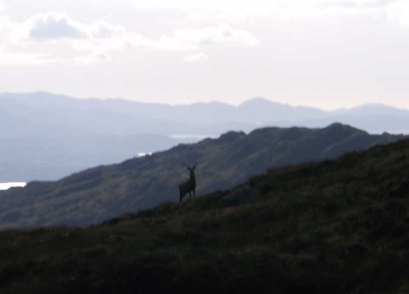
Picture: Stag near the summit
Rough Wild Wet
by ciarraioch
4 Nov 2012
Took in Cnoc Ramhar on the return loop from Dromderalough and Knockbrack. We descended to the col with the 'Shaking Rock' hill and contoured to the south of the latter until we reached Paddy MacConagle's famous (rock) Spike at around C (V919 787). Some of the roughest ground I have ever traversed, especially west/downhill of the spike. Returned to the car at ShakRk W (V916 796). Linkback: mountainviews.ie/summit/354/comment/14857/
Use of MountainViews is governed by conditions and a privacy policy.
Read general information about the site. Opinions in material here are not necessarily endorsed by MountainViews.
Hillwalking is a risk sport. Information in comments, walks, shared GPS tracks or about starting places may
not be accurate for example as regards safety or access permission. You are responsible for your safety and your permission to walk.
See the credits and list definitions.


 Our Facebook page.