This website uses cookies, which are small text files that the website puts on your device to facilitate operation. Cookies help us provide a better service to you. They are used to track general user traffic information and to help the website function properly.
Feature count in area: 57, by county: Cork: 32, Kerry: 36, of which 11 are in both Cork and Kerry,
OSI/LPS Maps: 83, 84, 85, 88
Highest Place: Hungry Hill 682m
Starting Places (51) in area Caha Mountains: Ardgroom, Barley Lake North, Bere Island Pier, Caha Pass, Canshanavoe South, Carriganine, Cashelkeelty Stone Circles Carpark, Castletownbere Lifeboat Harbour, Clashduff River Farm, Coolieragh Harbour Road, Coomadayallig Lake Road N, Coomadayallig Lake Road S, Cooryeen Lane, Cummer Lough East Road, Derreenataggart Stone Circle Road, Dromoghty Lough North, Dunboy Wood, Esk Boreen, Eyeries, Fehanah Lane, Garinish Island Pier, Glantrasna Bridge, Glenbeg Lough N, Glengarriff, Glengarriff Nature Reserve CP, Gleninchaquin Waterfall, Gowlaun Lough, Healy Pass, Healy Pass Hairpin, Ilnacullin Car Park, Kenmare Bridge, Knockacullin Lane, Leahill Bog, Leitrim Beg Standing Stone, Lough Inchiquin SE, Magannagan Stream, Molly Gallivan's Visitor Centre, Nora's Cottage, Old Lansdowne School, Owgarriff River Lane, Peg's Shop, Pooleen Wood Car Park, Red Trout Lake, Reenroe Bridge, River Drimminboy Track, Rossmackowen Bridge, Rossmackowen Cemetery, Shronebirrane Farm, Shronebirrane Road, Toberbanaha, Turner's Rock Tunnel
Summits & other features in area Caha Mountains: Cen: Hungry Hill: Coombane 510m, Derryclancy 554m, Hungry Hill 682m Cen: Knockowen: Cushnaficulla 594m, Glenkeel Top 417m, Knockastumpa 398m, Knockeirky 577m, Knockeirky South Top 523m, Knockowen 658m, Stookeennalackareha 412m E: Glengarriff: Derrynafulla SW 375m, Gowlbeg Mountain 362m, Nareera 530m, Nareera North Top 503m, Nareera South-West Top 505m, Shrone Hill 283m, Sugarloaf Mountain 574m, Sugarloaf Mountain Far West Top 560m, Sugarloaf Mountain West Top 565m N: Coomnadiha: Baurearagh Mountain 489m, Caha Far SE Top 555m, Caha SE Top 585m, Coomnadiha 644m, Coomnalack Top 435m, Cummeenbaun 510m, Droppa 522m, Killane Mountain 537m, Killane Mountain South-West Top 533m, Knockagarrane 414m, Knockreagh 500m N: Knockeirka: Barraduff Mountain 400m, Killaha Mountain 400m, Knockeirka 426m N: Knocknagorraveela: Derrysallagh 410m, Feorus East 474m, Knocknagorraveela 507m, Knocknagorraveela NE Top 464m N: Lauragh: Knockanoughanish 386m, Knockatee 330m S: Castletownbere: Disert 205m, Knockanallig (Bear Island) 267m W: Ardgroom: Derryvour Hill 160m W: Eskatarriff: Coomacloghane 599m, Eskatarriff 600.5m, Eskatarriff East Top 532.7m, Knocknaveacal North Top 509.1m, Knocknaveacal South Top 507.2m, Lackabane 603m, Tooreenbaha 408.7m, Tooreennamna 524m, Tooth Mountain 592m W: Knocknagree: Knocknagree 586m, Knocknagree East Top 461m, Knocknagree SE Top 442m, Lackawee 572m, Maulin 621m, Maulin North Top 579m
Note: this list of places may include island features such as summits, but not
islands as such.
Derryclancy, 554mMountain Doire Cluainsí A name in Irish,
Place Rating ..
(Ir. Doire Cluainsí [T6000], 'oak-grove of ?Cluainseach'), Cork/ Kerry County in Munster province, in Arderin Lists, Derryclancy is the 409th highest place in Ireland.
Grid Reference V76901 51325,
OS 1:50k mapsheet 84 Place visited by: 121members, recently by: Sarahjb, JohnFinn, DeirdreM, maoris, mh400nt, Ansarlodge, Djouce, miriam, CusackMargaret, Ianhhill, Kirsty, Carolyn105, johncusack, a3642278, DNicholson
I visited this place: NO (You need to be a logged-in member for this.)
Short or GPS IDs, 6 char: Drycln, 10 char: Deryclancy Linkback: https://mountainviews.ie/summit/353/
Gallery for Derryclancy (Doire Cluainsí) and surrounds
Summary
for Derryclancy (Doire Cluainsí):
Craggy top with fine views
Summary created by Colin Murphy
2011-05-16 17:00:30
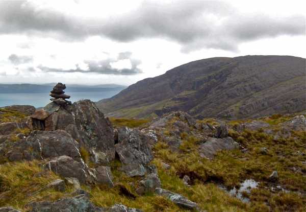
Picture: Summit stones
Park at the Healy Pass (Healy (V786 535)) and proceed directly up the steep slope to the south west. This eases into a gentler slope after a short climb. Continue SW, essentially following the Cork-Kerry border. The ground starts to rise more steeply again after a few hundred metres until you attain 450m altitude. Skirt the minor top called Coombane and continue on to the SW for approx 1km, the remainder of the journey being a relatively gentle incline. The going underfoot is generally firm, a mixture of grasses and small rocks. The summit itself is a blend craggy outcrops and grass. The outcrop topped with a small pile of stones is the highest point, at 554m, which on a clear day offers fine views in all directions, though especially of the rocky mass of Hungry Hill 1.5km to the south west. Journey time to summit 1 hour 15 minutes.
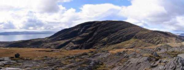
Part of a route we completed from the Healy Pass on the way to Hungry Hill. The rocky summit provides great views of Hungry Hill to the west and the Cummeengeera Horseshoe to the north and the innner part of Bantry Bay. The summit itself is covered in rocky outcrops and a few points could be determined as the highest point spread over a 100m radius. Nevertheless it is one of the few dry spots on an otherwise very boggy and rock slab strewn ridge.
The photo below is of Hungry Hill taken from the summit of Derryclancy, just visible with the angular rock slabs in the right foreground. Linkback: mountainviews.ie/summit/353/comment/935/
Read Less
Read More
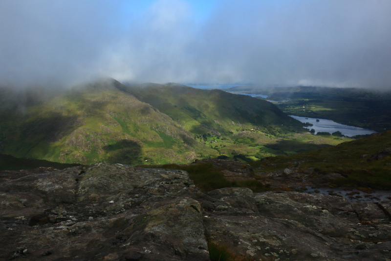
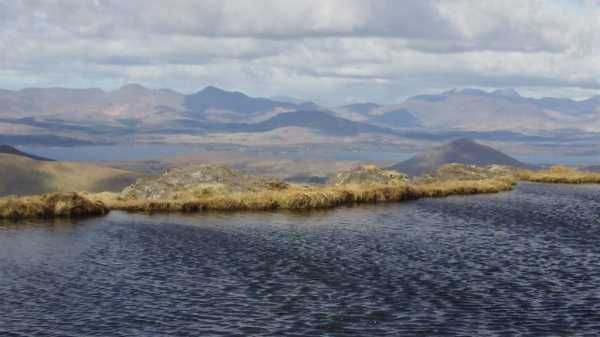
Picture: Lackabane and Glanmore Lake as the clouds part.
Stormy Weather But Great Views
by Aidy
1 Aug 2016
I went over Derryclancy and Coombane on the the way from the top of the Healy Pass to Hungry Hill. It was the worst day, weather wise of our weeks holiday in West Cork, and visibility was practically zero for most of the walk, and I was drenched by the end of the walk. It was all worth it though, even though I had no views on Hungry Hill, as the sun broke through the clouds as I returned over Derryclancy and Coombane. On the slightly lower ground, I was now just below the cloud ceiling too, and the views over to Lackabane and Glanmore Lake were stunning in the stormy weather. Linkback: mountainviews.ie/summit/353/comment/18601/
Use of MountainViews is governed by conditions and a privacy policy.
Read general information about the site. Opinions in material here are not necessarily endorsed by MountainViews.
Hillwalking is a risk sport. Information in comments, walks, shared GPS tracks or about starting places may
not be accurate for example as regards safety or access permission. You are responsible for your safety and your permission to walk.
See the credits and list definitions.


 Our Facebook page.