This website uses cookies, which are small text files that the website puts on your device to facilitate operation. Cookies help us provide a better service to you. They are used to track general user traffic information and to help the website function properly.
Feature count in area: 58, all in Down,
OSI/LPS Maps: 20, 29, EW-CLY
Highest Place: Slieve Donard 849m
Starting Places (33) in area Mourne Mountains: Alex Steddom Tree, Aughrim Airstrip, Ben Crom Dam, Bloody Bridge Car Park, Carlingford Greenway, Carrick Little, Crocknafeola Wood, Crotlieve Mountain, Donard Car Park Newcastle, Drummanmore Picnic, Fofanny Reservoir, Forest Office CP, Gamekeepers Lodge CP, Happy Valley Trassey Rd, Hen Mountain CP, Leitrim Lodge CP, Mayo Road Corner, Meelmore Lodge, Newcastle Harbour, Ott CP, Red Bog Road, Rourkes Park, Sandy Brae, Silent Valley Reservoir Head Rd, Slieve Donard Trail Head, Slieve Foye Viewing Point, Slievefoy Forest CP, Spelga Dam E, Spelga Dam N, Spelga Dam S, Trassey Car Park, Two Mile River CP, Yellow Water Park
Summits & other features in area Mourne Mountains: Cen: Loughshannagh: Ben Crom 526m, Carn Mountain 585.2m, Carn Mountain North Top 553.7m, Doan 592.6m, Ott Mountain 526.8m, Slieve Loughshannagh 617m, Slieve Muck 670.4m, Slievenaglogh 445m E: Binnian: Slieve Binnian 745.9m, Slieve Binnian East Top 639m, Slieve Binnian North Top 678m, Slieve Binnian North Tor 682.5m, Wee Binnian 460m E: Donard: Chimney Rock Mountain 656m, Crossone 540m, Millstone Mountain 460m, Rocky Mountain 524m, Slieve Donard 849m E: Lamagan: Cove Mountain 654.8m, Slieve Beg 595.9m, Slievelamagan 702.2m N: Bearnagh: Slieve Bearnagh 739m, Slieve Bearnagh North Tor 680m, Slieve Meelbeg 701.9m, Slieve Meelmore 687m N: Castlewellan: Slievenalargy 280m, Slievenaslat 272m N: Commedagh: Slieve Commedagh 767m, Slieve Corragh 641.9m, Slievenaglogh 584.4m, Slievenaglogh East Top 571m N: Croob: Cratlieve 429m, Slieve Croob 534m, Slievegarran 391m, Slievenisky 446m N: Rathfriland: Knockiveagh 235m S: Kilkeel: Knockchree 306m S: Rostrevor: Crenville 460m, Finlieve 578m, Slievemartin 485m, Slievemeel 420m, Slievemeen 472m W: Hilltown: Gruggandoo 382m, Slieveacarnane 296m W: Slievemoughanmore: Crotlieve Mountain 347m, Eagle Mountain 638m, Rocky Mountain 404m, Shanlieve 626m, Slievemoughanmore 560m, Tievedockaragh 473m, Wee Slievemoughan 428m W: Spelga: Butter Mountain 500m, Cock Mountain 504m, Cock Mountain South-West Top 505m, Hen Mountain 354m, Pigeon Rock Mountain 534m, Pigeon Rock Mountain South Top 530m, Slievenamiskan 444m
Note: this list of places may include island features such as summits, but not
islands as such.
Slievemoughanmore, 560mMountain
Place Rating ..
Of uncertain origin [PNNI]., Down County in Ulster province, in Arderin Lists, Slievemoughanmore is the 395th highest place in Ireland.
Grid Reference J24959 24095,
OS 1:50k mapsheet 29 Place visited by: 290members, recently by: trostanite, Magic, Carolineswalsh, Oscar-mckinney, ElaineM76, Lyner, Alanjm, MichaelButler, Mark1, just.explores, NualaB, feargalf, Florence, Bob-the-juggler, Cecil1976
I visited this place: NO (You need to be a logged-in member for this.)
Longitude: -6.088438, Latitude: 54.150541, Easting: 324959, Northing: 324095,
Prominence: 154m, Isolation: 0.9km ITM: 724869 824082 Bedrock type: Granite granophyre, (Mourne Mountains granite) Notes on name: It is the element -moughan- which is obscure in this case. The name appears on 16th century maps as Slew Mogh or just Mogh.
Short or GPS IDs, 6 char: Slvmgh, 10 char: Slvmghnmr Linkback: https://mountainviews.ie/summit/344/
Gallery for Slievemoughanmore and surrounds
Summary
for Slievemoughanmore :
Just follow the wall.
Summary created by jackill
2014-09-03 12:35:35
Park at the back of Spelga reservoir on the roadside next to the track that accesses the reservoir, room for 8-10 cars.
Head west following the wall to the summit of Pigeon rock, follow the wall southeast for about 300 meters then south west to A (J25050 23940) where you will need to head north west for 150 meters to reach the summit area.
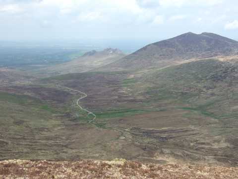
The more spontaneous of us will come at Slievemoughanmore as the crow flies - ex the Rocky River track from the Rocky River Bridge and find her at 559m, small and undemanding. The rest of us will more than not, encounter her after a run of anything from one (Pigeon Rock) to three (Hen, Cock, Pigeon -or- Rocky, Tornamrock, Eagle) tops, when she becomes a brief but tough old haul to her lonely and desolate summit. Unlike the Eastern Mournes where summits are defined by a kink in the wall, a trig point or some other obstacle enroute (excepting Commedagh), most of the cairns in the Shanlieve Group require a short, if albeit disorienting deviation from your main route - Batts Wall Slievemoughanmore is no exception. From here it is but a short lep to the matriach/s of the clann, Eagle-come-Shanlieve effectively two tops of the same hill - and if you would forego the classic horseshoe configuration, thereafter south along the truly Great Gully. If you want a more diverting and odder experience, head North straight off her, into the void. I think it was Chris Bonnington once questioned by a tabloid interviewer if he believed sightings of Abominable Snowman genuine, replied that in continuous exposure to such emptiness, AS was the least you would “sight”. The confluence of the Rocky and Rowan Tree rivers framing Slievemoughanmore presents one such emptiness and it is awesome. The ribs of recently deceased turf-digging corrugate the landscape and expose the skeletons of broken bog oak. Nothing with living branches exceeds an inch above the ground. And it seems to go on forever. The tors of Hen in the distance add to this moonscape tableau and threaten like ancient guardians of the glen. Watch they don’t get you on the way home. Linkback: mountainviews.ie/summit/344/comment/2348/
Read Less
Read More
Great views for minimal effort
by paulocon
23 Aug 2010
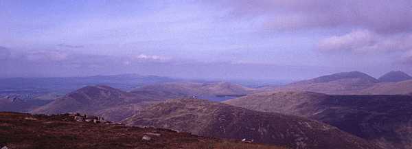
Started from Deers Meadow and climbed Slievemoughanmore after Pigeon Rock following Batts Wall. The summit is around 150 metres away from the wall and is marked by two cairns, neither of which appear to mark the actual summit proper. Great views across to Spelga Dam, Cock and Hen Mountain and onto Meelbeg, Meelmore and Bearnagh. Linkback: mountainviews.ie/summit/344/comment/6049/
Read Less
Read More
tsunami on Slievemoughanmore
by tsunami
10 Feb 2005
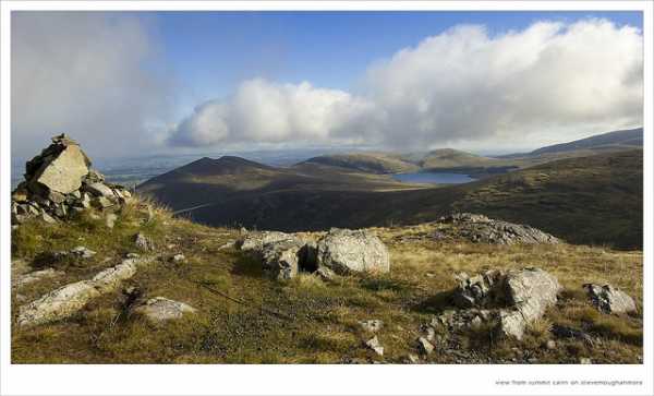
Much like the ever trustworthy Mourne Wall, which provides a timeless companion and navigation aid around the High Mournes summits, so Batts Wall fulfills a similar role around the higher peaks of the Western Mournes. Seen hear crossing Slieve Moughanmore just to the south east of it's summit, it offers a very nice route from Altataggart, across Shanlieve, Eagle Mountain, Slieve Moughanmore, Pigeon Rock Mountain and up Slieve Muck where it links the Mourne Wall and leaves the walker spoilt for choice. This view was taken from the summit of Eagle Mountain. Linkback: mountainviews.ie/summit/344/comment/1472/
Read Less
Read More
gary on Slievemoughanmore
by gary
29 Dec 2004
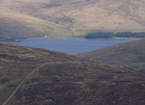
Excellent view on a summer’s day! Spelga Dam is in the centre of the picture. Far left is Hen then Cock; Pigeon Rock Mountain in the foreground and Slieve Muck to the right (if I’m not mistaken). In the distance, to the right, is the sweeping rise of Slieves Meelbeg and Meelmore and finally the unmistakable outline of Slieve Bearnagh. That's my map reading skills being pushed to the limit (if any of those peaks are wrong, please contact the webmaster - Thanks. Linkback: mountainviews.ie/summit/344/comment/1379/
Read Less
Read More
Pigeon- Moughanmore walk
by hbowman
16 May 2010
I climbed Slievemoughanmore for the first time yesterday in fairly good conditions. Started off from Deer's Meadow and followed the Mourne wall over Pigeon. From this point fine views opened up of Spelga Dam. As we continued to follow the wall, we ascended Slievemoughanmore. From the summit we could see Cock and Slievenamiskan to the west and Bernagh and Slieve Muck further afield. Thereafter we descended to the WIndy Gap and saw Rocky, Tornamock and Pierce's Castle. After lunch we followed the path beside the Great Gully of Eagle (very impressive). Upon returning to the wall we headed straight towards Pigeon's lower car park and enjoyed very impressive views of Slievenaglogh and the Binnians - a good 7 mile walk which I would recommend. Linkback: mountainviews.ie/summit/344/comment/4743/
Use of MountainViews is governed by conditions and a privacy policy.
Read general information about the site. Opinions in material here are not necessarily endorsed by MountainViews.
Hillwalking is a risk sport. Information in comments, walks, shared GPS tracks or about starting places may
not be accurate for example as regards safety or access permission. You are responsible for your safety and your permission to walk.
See the credits and list definitions.


 Our Facebook page.