This website uses cookies, which are small text files that the website puts on your device to facilitate operation. Cookies help us provide a better service to you. They are used to track general user traffic information and to help the website function properly.
Feature count in area: 27, by county: Mayo: 15, Galway: 15, of which 3 are in both Galway and Mayo,
OSI/LPS Maps: 37, 38, CBE, EW-CON, MSW
Highest Place: Maumtrasna 682m
Starting Places (53) in area Partry & Joyce: Aasleagh Waterfall CP, An Móinín Mór, Ballydoo Lough, Barrevagh Bridge, Bealanabrack River Tributary, Black Rock, Bohaun, Bracklagh, Buckaun, Bunduvowen, Cammanagh, Carraig Bar, Carrowrevagh Lough, Clonbur, Cummer, Derrassa, Derrinkee Wood, Doon Rock, Failmore River, Finny Church, Fooey River Road, Glendavock, Glenmask, Glennacally Bridge, Glensaulmore Trailhead, Glentraigue, Gowlaunlee Lake, Keelkill North, Killeennimat Burial Ground, Knockaunnabausty (Cnocán na bPáistí), Knocknafaughy SW, Lecarrow, Leenane, Leenane Hotel, unuseableLeenane R336, Lough Nambrackkeagh, Maum Bridge Road Lower, Maum Bridge Road Mid, Maum Bridge Road Upper, Mount Gable CP, Otter Pool, Owenbrin Bridge, Owenbrin Tributary, Owenduff River, Red Island, RIC Barracks Ruin, Rinavore East, Rinavore SW, Shanafaraghhaun Cross, Sheeffry Pass, Tawnyard Lough, Teevinish West, The Larches Pub
Summits & other features in area Partry & Joyce: Cen: Finny: Glenbeg East 372m Cen: Knocknafaughy: Knocknafaughy 254m, Rinavore 426m Cen: Maumtrasna: Barnahowna 516m, Buckaun East 495m, Glennagleragh Mtn 617m, Knocklaur 518m, Maumtrasna 682m, Maumtrasna North-East Top 572m, Tullymorehill 279m N: Ballintober Hills: Bohaun 393m, Corveagh 233m, Croaghrimkarra 271m, Keelkil 239m SE: Cornamona: Mount Gable 417.8m, Bohaun 424m, Knocknagussy 456m SW: Bunnacunneen: Ben Beg 560m, Bunnacunneen 575m, Bunnacunneen South Top 539m, Bunnacunneen SE Top 479m, Lugnabrick SW Top 494m, Lugnabrick NE Top 494m W: Devilsmother: Devilsmother 645m, Devilsmother South Top 509m, Devilsmother North Top 595m, Devilsmother Far North Top 601m
Note: this list of places may include island features such as summits, but not
islands as such.
Ben Beg, 560mMountain An Binn Bheag A name in Irish,
Place Rating ..
Ir. An Binn Bheag [logainm.ie], 'little peak’, Galway County in Connacht province, in Arderin Lists, An Binn Bheag is the 394th highest place in Ireland.
Grid Reference L95093 57894,
OS 1:50k mapsheet 38 Place visited by: 104members, recently by: Oscar-mckinney, Jai-mckinney, Carolineswalsh, Carolyn105, dodser, Kaszmirek78, Geo, DNicholson, farmerjoe, Niamhq, bryanjbarry, Sweeney, elizauna, pcoleman, annem
I visited this place: NO (You need to be a logged-in member for this.)
Short or GPS IDs, 6 char: BnBg, 10 char: Ben Beg Linkback: https://mountainviews.ie/summit/342/
Gallery for Ben Beg (An Binn Bheag) and surrounds
Summary
for Ben Beg (An Binn Bheag):
Rarely Visited Summit with Varied Views
Summary created by Onzy
2014-06-24 09:36:02
Picture: pic:Geansai
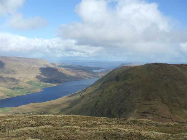
Ben Beg is a seldom visited peak situated across the R336 to the north and east of the Maamturks range. There are great views of both the Maamturks themselves and wider Connemara, as well the views north over Lough Nafooey and east over Lough Mask.
The peak can be approached in a number of ways. Perhaps the most straightforward is an ascent from the Drishaghaun Valley; parking is difficult in the valley, but there are a couple of places at GlTraig (L97196 56996), and also at BrVagh Bg (L9782 5684). From the first of these, cross the fence and contour west with a touch of north before reaching a river gully. Follow this gully northwest, contour around point 542 and head west to the summit, about an hour and a half of an ascent.
A further option starts from Finny at around A (M003 594) and takes in the entire and impressive ridge to the east of Ben Beg. Close to the Finny end of the ridge, on Bencorragh (not MV listed), there are examples of pillow lava, and other evidence of volcanic activity between here and Finny itself. From Finny to Ben Beg should take about 3 hours one way.
To get the best from Ben Beg however, it is better to combine it with a number of other hills. The Drishaghaun Valley lends itself to making a compact circuit taking in Ben Ben, Bunnacunneen, its SE Top and the two Lugnabricks. This can be done in either direction, starting from the parking places indicated above. The entire circuit should take under 4 hours.
A walk along the east-west ridge of Ben Beg gives great views of the deeply cut valleys of Maumtrasna and Lough Nafooey with hints of the many summits surrounding the area. This summit is very seldom visited, yet this view is well worth having as well as the view east over Lough Mask.
One way to visit this summit is from the Drishaghaun valley, to the SE. There isn't much parking however one or two cars could be put on the public road near the bridge at BrVagh Bg (L9782 5684). There is probably more than one way up that is unlikely to cause offence such as towards the graveyard shown on the 1:50k or at the most westerly point on the road. Comments welcome on these suggestions. Another way is to leave the road at Le'caro (L98120 57236) which is over a rough field with an apparently deserted building on it. As always, if in doubt, ask.
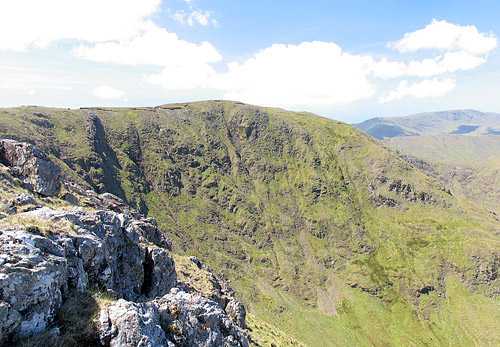
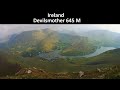
The photo shows the north facing cliffs of Ben Beg. To the right on the skyline is Leenane Hill (618m) and the ridge below that is Rinavore (426m). Linkback: mountainviews.ie/summit/342/comment/2370/
Read Less
Read More
beads on Ben Beg
by beads
9 Sep 2007
Climbed Ben Beg on Sunday 9th Sept 2007.On my own as friends were gone to Belgium
walking for the week.Found it to be a very nice walk. Came to a point where there was a
little chimney gully that was an option instead of going around it,took the gully option and was delighted that it saved me time instead of going around it.Bringing friends out there on 23rd Sept. Great views of the Maumturks,Devils Mother,Mweelrea and Mauntrasna. Linkback: mountainviews.ie/summit/342/comment/2817/
Read Less
Read More
Bencorragh from Finny end
by jkforde
27 Jun 2011
how's it going folks? has anyone gone up Benbeg from the east end, eg. from Finny (A (M003 594)) and taking in Bencorragh? There's some v v interesting 500 million year old volcano-type geology up in them there hills and the pillow lavas on Bencorragh and Benbeg are meant to be the real deal - see this Geological Survey Of Ireland short guide for the Finny end: http://www.gsi.ie/Education/Sites+Walks+Field+Trips/Walk+1+Volcano.htm
Went up today from Finny side and just to share some pics... and the pillow lavas at B (L983 586) are worth the walk... here's the geological context again... http://www.gsi.ie/Education/Sites+Walks+Field+Trips/Walk+1+Volcano.html Linkback: mountainviews.ie/summit/342/comment/19616/
Use of MountainViews is governed by conditions and a privacy policy.
Read general information about the site. Opinions in material here are not necessarily endorsed by MountainViews.
Hillwalking is a risk sport. Information in comments, walks, shared GPS tracks or about starting places may
not be accurate for example as regards safety or access permission. You are responsible for your safety and your permission to walk.
See the credits and list definitions.


 Our Facebook page.