This website uses cookies, which are small text files that the website puts on your device to facilitate operation. Cookies help us provide a better service to you. They are used to track general user traffic information and to help the website function properly.
Feature count in area: 62, by county: Cork: 45, Kerry: 24, of which 7 are in both Cork and Kerry,
OSI/LPS Maps: 78, 79, 85, 86, 88, 89
Highest Place: Knockboy 704.8m
Starting Places (47) in area West Cork Mountains: Barley Lake North, Barrboy, Caha Pass, Carranmore, Carrigacappeen, Carriganass Castle, Castle Donovan Car Park, Clearagh House, Coolkellure House, Coomhola Bridge, Corrigatirra, Cousane Gap, Cummer Lough East Road, Derreencollig Wood, Esk Boreen, Fuhiry Wood, Garinish Island Pier, Glasagarav River Bridge, Glasnacummeen Stream, Glengarriff, Glengarriff Nature Reserve CP, Gorteeniher Drimoleague Heritage Walk CP, Gortloughra River Road, Gougane Barra Oratory, Gougane Barra Park CP, Grousemount Wind Farm, Kealkill Village, Knockanuha, Knockbrack South, Lough Atooreen N, Lough Nambrackderg North, Lough Nambrackderg Wood, Lough Nambreacdearg, Mealagh Bridge, Molly Gallivan's Visitor Centre, Nowen Hill West Road, Owvane River Bridge, Pookeen North Top Road, Pooleen Wood Car Park, Priests Leap, Reenroe Bridge, River Roughty, Shandrum Concrete Silo, Sillahertane Stream, Slaheny River Horseshoe, Top of Coom, Turner's Rock Tunnel
Summits & other features in area West Cork Mountains: Cen: Maughanaclea: Maughanaclea Hills East Top 470m, Maughanaclea Hills West Top 452m Cen: Shehy More: Shehy More 545.6m, Shehy More SW Top 446m E: Clearagh: Clearagh Hill 287m E: Currane: Currane Hill 228m N Cen: Douce: Douce Mountain 476m, Doughill Mountain 471m N: Carran: Barnastooka 497m, Bealick 537m, Carran 604m, Carran Far NE Top 561m, Carran Far North Top 506m, Carran NE Top 555m, Carran South Top 567m, Knockantooreen 450m N: Conigar: Conigar 566m, Conigar SW Top 566m, Foilastookeen 540m N: Coomataggart: Carrigalougha 423m, Coomataggart 530m, Coomataggart SW Top 509m, Derrineanig 304m, Lackabaun 472m, Mweelin 487m NE Cen: Carrigarierk: Carrigarierk 343m NW: Barraboy: Barraboy Mountain 460m, Barraboy Mountain Far East Top 456m, Barraboy Mountain SE Top 409m, Derroograne 468m, Turners Rock 420m NW: Knockboy: Caoinkeen 692.8m, Caoinkeen South-East Top 553.5m, Coomhola Mountain 472m, Knockboy 704.8m, Knockboy North Top 651.2m, Knockboy South Top 533.3m, The Priest's Leap 519m NW: Knocknamanagh: Bird Hill 412m, Coomclogherane Top 449m, Gullaba Hill 603m, Knockbrack 440m, Knockbrack South Top 458m, Knocknamanagh 637m, Knocknamanagh NE Top 625m S Cen: Dunmanway Hills: Cashloura 296.8m, Coolsnaghtig 295.8m, Inchanadreen 310m S Cen: Nowen: Milane Hill 354.4m, Mullaghmesha 494.3m, Nowen Hill 535.2m, Nowen Hill Far West Top 405.2m, Nowen Hill SW Top 509m, Pookeen North Top 319m S: Leap Hills: Carrigfadda 311.7m, Killeigh Hill 229m, Knockarudane Hill 169m, Knockscagh 195m S: Skibbereen: Barryroe Hill 156m, Lick Hill 158m W Cen: Knockbreteen: Knockbreteen 239m W: Bantry: Knocknaveagh 282m
Note: this list of places may include island features such as summits, but not
islands as such.
Carran South Top, 567mMountain An Carn (Mullach Theas) A name in Irish,
Place Rating ..
For origin of name, see Carran., Kerry County in Munster province, in Arderin Lists, Carran South Top is the 372nd highest place in Ireland.
Grid Reference W05468 67036,
OS 1:50k mapsheet 85 Place visited by: 68members, recently by: JohnFinn, DeirdreM, No1Grumbler, CusackMargaret, johncusack, a3642278, Krzysztof_K, derekfanning, hivisibility, dodser, jackos, annem, wicklore, madfrankie, chelman7
I visited this place: NO (You need to be a logged-in member for this.)
Short or GPS IDs, 6 char: CrnSth, 10 char: CrnSthTp Linkback: https://mountainviews.ie/summit/331/
Gallery for Carran South Top (An Carn (Mullach Theas)) and surrounds
Summary
for Carran South Top (An Carn (Mullach Theas)):
An uninspiring summit
Summary created by liz50
2019-03-20 21:42:59
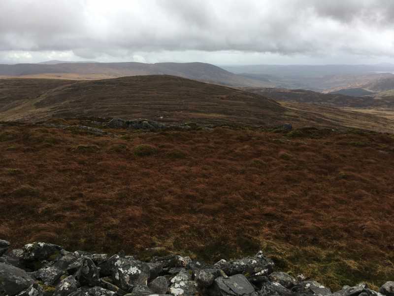
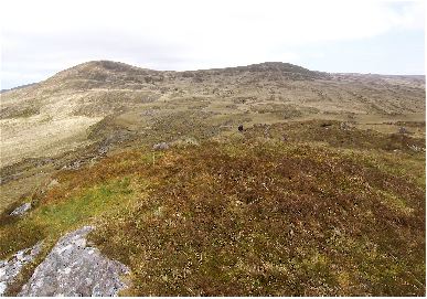
Picture: Carran South top from Carran main top
The shortest approach to Carran S top is from Bealick. Starting from Gougane Barra forest park A (W070 653) C. Follow trail to it's high point then head North to Bealick then follow a fence to Carran S top.
Alternativly start from the KIlgarvan side following a track at B (W035 662).
Carran S top can be taken in as part of a longer route including all 4 Carran tops starting near a farmyard at C (W039 689)
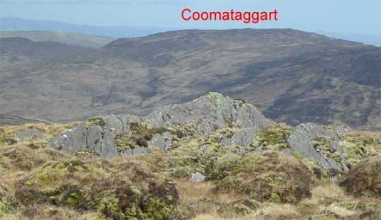
Picture: Summit in the immediate foreground with Coomataggart in the distance
john_desmond on Carran South Top
by john_desmond
22 Apr 2006
I approached this one from the South-East side, from Bealick. The ground was very boggy and it was slow going. If I was going to do it again, I think I'd come in from the public road from the Kilgarvan side and go up the track at B (W035 662) . Looking down at this road from the summit, you realise how close it is. From here, it is only a short walk to Carran itself and the going is easier. As for the summit itself, you have a choice of 2 points. They are only about 10 metres apart. There are a few stones on the Southern one although by looking at the mountains in the background, I'd reckon the Northern one is the highest and this is where I took the GPS readings. In terms of location, this summit is not part of any obvious loop circuit and as such, it is a bit out of the way. Having completed a walk of all the Carran tops, I saw no sign of footprints or erosion which would suggest that very few people walk in this part of Kerry. Linkback: mountainviews.ie/summit/331/comment/2294/
Read Less
Read More
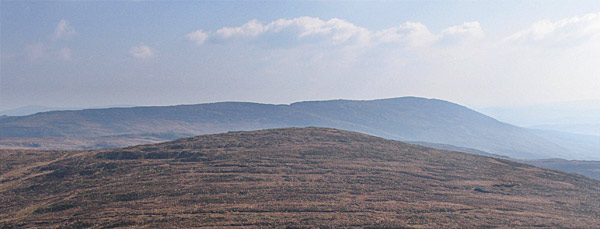
Picture: Carran South
simon3 on Carran South Top
by simon3
29 May 2006
Another way in to the Carran area starts at around D (W03939 68915) where there is parking for one car or perhaps a bit further east where the tarmac road stops with permission from the people that live near there.
Getting to Carran South requires going first east into the fine west facing coum. Turn right at around E (W04857 68778) and SW via tracks to F (W04138 67735). From there it is possible to get to Carran South relatively easily (or Carran)
The picture shows Carran South from Carran. Not exactly a steep sided summit! As john_desmond says this place is a bit out of the way and rarely visited. The summit on the skyline to the right is Conigar. Linkback: mountainviews.ie/summit/331/comment/2355/
Read Less
Read More
Bealick - avoid this descent...
by Conor74
6 Sep 2010
Putting this comment in with Carran South Top as it is the nearest summit, but guess it really applies to any walk in the popular Gougane Barra area. Parked at Gougane Barra lake, and walked Conigar and over Bealick and on to Carran South Top and Carran yesterday in driving wind and rain.
From Carran descended to the valley to the east, then walked south east making for the lowest point between Bealick and the spot height 509 to its North. From there made straight for Gougane Barra which looked like the most direct route, if a bit steep - REALLY bad idea. Fought my way through tall grass, which went above the waist in parts and hid very uneven ground, so had a few falls along the way though the thick grass at least made for soft landings. This grew progressively wilder, incorporating fern, then furze and fern, then furze fern and an absolute jungle of briars. The briar belt seemed to extend for a long long way, was fighting my losing battle through it for the bones of half an hour, and the steepness of the descent I had just come down made turning around less appealing than having arms and legs ripped. Crossed a few fences as well, hoping that they would mark more cultivated ground, but things did not get better until I was almost at the lake itself. Maybe I was unfortunate and there are easier routes above the lake, but wouldn't bank on it. Linkback: mountainviews.ie/summit/331/comment/6086/
Use of MountainViews is governed by conditions and a privacy policy.
Read general information about the site. Opinions in material here are not necessarily endorsed by MountainViews.
Hillwalking is a risk sport. Information in comments, walks, shared GPS tracks or about starting places may
not be accurate for example as regards safety or access permission. You are responsible for your safety and your permission to walk.
See the credits and list definitions.


 Our Facebook page.