This website uses cookies, which are small text files that the website puts on your device to facilitate operation. Cookies help us provide a better service to you. They are used to track general user traffic information and to help the website function properly.
Feature count in area: 27, by county: Mayo: 15, Galway: 15, of which 3 are in both Galway and Mayo,
OSI/LPS Maps: 37, 38, CBE, EW-CON, MSW
Highest Place: Maumtrasna 682m
Starting Places (53) in area Partry & Joyce: Aasleagh Waterfall CP, An Móinín Mór, Ballydoo Lough, Barrevagh Bridge, Bealanabrack River Tributary, Black Rock, Bohaun, Bracklagh, Buckaun, Bunduvowen, Cammanagh, Carraig Bar, Carrowrevagh Lough, Clonbur, Cummer, Derrassa, Derrinkee Wood, Doon Rock, Failmore River, Finny Church, Fooey River Road, Glendavock, Glenmask, Glennacally Bridge, Glensaulmore Trailhead, Glentraigue, Gowlaunlee Lake, Keelkill North, Killeennimat Burial Ground, Knockaunnabausty (Cnocán na bPáistí), Knocknafaughy SW, Lecarrow, Leenane, Leenane Hotel, unuseableLeenane R336, Lough Nambrackkeagh, Maum Bridge Road Lower, Maum Bridge Road Mid, Maum Bridge Road Upper, Mount Gable CP, Otter Pool, Owenbrin Bridge, Owenbrin Tributary, Owenduff River, Red Island, RIC Barracks Ruin, Rinavore East, Rinavore SW, Shanafaraghhaun Cross, Sheeffry Pass, Tawnyard Lough, Teevinish West, The Larches Pub
Summits & other features in area Partry & Joyce: Cen: Finny: Glenbeg East 372m Cen: Knocknafaughy: Knocknafaughy 254m, Rinavore 426m Cen: Maumtrasna: Barnahowna 516m, Buckaun East 495m, Glennagleragh Mtn 617m, Knocklaur 518m, Maumtrasna 682m, Maumtrasna North-East Top 572m, Tullymorehill 279m N: Ballintober Hills: Bohaun 393m, Corveagh 233m, Croaghrimkarra 271m, Keelkil 239m SE: Cornamona: Mount Gable 417.8m, Bohaun 424m, Knocknagussy 456m SW: Bunnacunneen: Ben Beg 560m, Bunnacunneen 575m, Bunnacunneen South Top 539m, Bunnacunneen SE Top 479m, Lugnabrick SW Top 494m, Lugnabrick NE Top 494m W: Devilsmother: Devilsmother 645m, Devilsmother South Top 509m, Devilsmother North Top 595m, Devilsmother Far North Top 601m
Note: this list of places may include island features such as summits, but not
islands as such.
Bunnacunneen, 575mMountain Binn Uí Chuinneáin A name in Irish,
Place Rating ..
Ir. Binn Uí Chuinneáin [logainm.ie], 'Kinnane’s peak’, Galway County in Connacht province, in Arderin Lists, Binn Uí Chuinneáin is the 349th highest place in Ireland.
Grid Reference L93896 57734,
OS 1:50k mapsheet 38 Place visited by: 117members, recently by: Oscar-mckinney, Jai-mckinney, Carolyn105, dodser, marktrengove, Geo, farmerjoe, Niamhq, bryanjbarry, abeach, Sweeney, elizauna, annem, John.geary, TommyMc
I visited this place: NO (You need to be a logged-in member for this.)
Longitude: -9.601912, Latitude: 53.558963, Easting: 93896, Northing: 257734,
Prominence: 463m, Isolation: 0.4km ITM: 493869 757754 Bedrock type: Conglomerate, sandstone, mudrock, tuff, (Rosroe Formation) Notes on name: The anglicised form Bunnacunneen appears to be a corruption. It would suggest an original Irish name *Bun an Choinín, which would mean 'the end or tail of the rabbit’, but the true name is Binn Uí Chuinneáin, 'Kinnane’s peak’. Walks: for a route to the summit from the SW, see Whilde & Simms, New Irish Walk Guide - West and North, 54-55.
Short or GPS IDs, 6 char: Bncnn, 10 char: Bunacunen Linkback: https://mountainviews.ie/summit/318/
Gallery for Bunnacunneen (Binn Uí Chuinneáin) and surrounds
Summary
for Bunnacunneen (Binn Uí Chuinneáin):
Superb Vantage Point above Connemara
Summary created by Onzy
2014-10-30 11:56:10
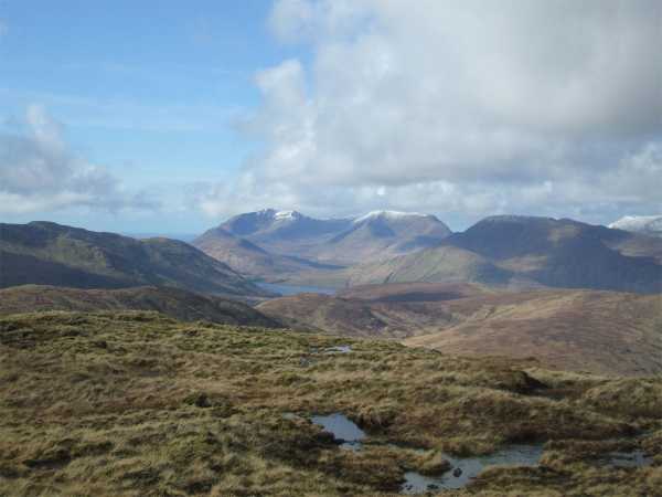
Picture: pic:Geansai, View from the summit
Bunnacunneen is a well located peak situated across the R336 to the north and east of the Maamturks range; It has a full 360 degree views from its summit. The views are stunning on a good day, taking in the whole range of the Maamturks, Ben Gorm, Mweelrea, Devil’s Mother, Maumtrasna and the Sheefry Hills, as well as Croagh Patrick and the Nephion Beg range.
The peak can be approached in a number of ways. For a quick ascent of Bunnacunneen by itself, the most obvious routes are from the west, parking along the minor road and following the south western spur, or the river valley itself which leads almost to the summit.
Another is from the Drishaghaun Valley; parking is difficult in the valley, but there are a couple of places at GlTraig (L97196 56996), and also at BrVagh Bg (L9782 5684). From the first of these, cross the fence and contour west with a touch of north before reaching a river gully. Follow this gully northwest, contour around point 542 and head west to Ben Beg. Over Ben Beg head west; there is a descent of 140m before the pull up to Bunnacunneen. 1.45 hours should see you at the top.
Bunnacunneen is best combined with a number of other hills. The Drishaghaun Valley lends itself to making a compact circuit taking in Ben Ben, Bunnacunneen, its SE Top and the two Lugnabricks. This can be done in either direction, starting from the parking places indicated above. The entire circuit should take under 4 hours.
Just south of the summit there are two bright red warning signs 'No unauthorised access beyond this point'. They are attached to the boundary fence that runs along the ridge,and they are confusingly situated near the boundary to dissuade any walking,although technically they only refer to a short strect of commonage that runs down to the glenteige,east side of the ridge. Linkback: mountainviews.ie/summit/318/comment/6673/
Read Less
Read More
Heavy Hitter
by Geansai
20 Mar 2012
Having been to the roofs of the Maamturks and Bens on clear days I think Bunnacunneen is in the same class for Connemara views. This is right in front of the main cairn looking towards the Mweelreas with Ben Gorm to their right and a bit of Killary Harbour visible below them. Further to the right were views of the Sheefreys and Croagh Patrick beyond. To the left and well beyond of Croagh Patrick was a faint shape that I think may have been Corraun Hill right beside Achill Island. Other faint shapes to its right may be some of the Nephins. Turn to the right from this point and there's another cairn just a few yards away on the edge of a steep drop into the beautiful Lough Nafooey valley with Lough Mask in the distance and the top of the Maamtrasna plateau to the north. Turn around 180 degrees and you can see Lough Corrib over the ridges behind. i didn't bother mentioning Devils Mother and the Leenane branch of the Maamturks and the Atlantic Ocean beyond Mweelrea. Actually this might be a contender for the most spectacular spot in Co Galway. Just don't come here in mist which unfortunately is not a rarity round here. Like going to see Barcelona when Messi and Iniesta are being rested. Linkback: mountainviews.ie/summit/318/comment/6726/
Read Less
Read More
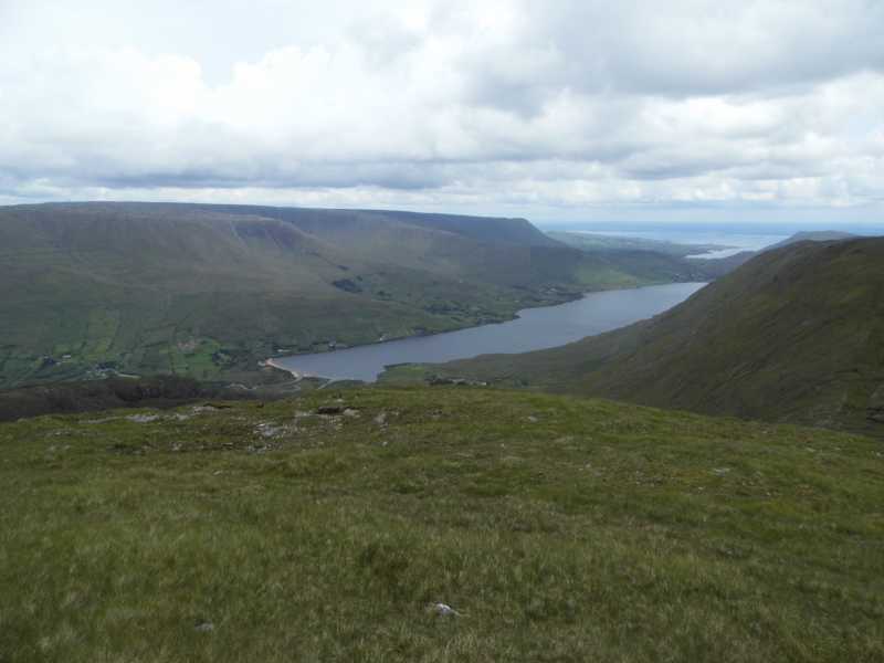
Picture: Looking down on Lough Nafoey
A short reward
by TommyV
24 Jun 2019
I tackled Bunnacunneen from the West which is a short, steep, direct climb to the summit.There is room to park at A (L92734 58016) for one car. From here hop the fence and handrail the stream for the first part of the hike. After the stream veer slightly South East and a fence will lead you to the summit. As this mountain lies on the Easten end of Connemara you get to experience views not only of all the Connemara mountain ranges but also Lough Nafoey, Lough Corrib and Lough Mask and the contrasting flatter plains of Galway and Mayo. Linkback: mountainviews.ie/summit/318/comment/20561/
Read Less
Read More
mreeyore on Bunnacunneen
by mreeyore
6 May 2004
Bunnacunneen is a rarely climbed mountain in comparison to the nearby Maumturks. The summit is flat and vegetated with numerous peat hags. An interesting short walk follows the stream that leads from the road which takes you into the "heart" of the mountain an unusual place where you will find yourself almost entirely surrounded by the mountain, from here it's an easy climb up the right fork in the stream to the ridge which runs north to the summit and from there back down along the main ridge running south. There are quite a few fences to be encountered along the way and most of this land is farmed so you may want to check in with the farm at the southern base of the mountain. The views from the top are worth a mention as you get an excellent view of all the Maumturks aswell as views down Lough NaFooey and across to Devil's Mother. Linkback: mountainviews.ie/summit/318/comment/960/
Read Less
Read More
Picture: Bunnacunneen and summits north of it.
simon3 on Bunnacunneen
by simon3
13 Jun 2006
Why would you go up Bunnacunneen? True at 575m it isn't so high and true it is has hardly the same grand slopes as many of the surrounding ranges. However on a good day it has a full 360 degrees of view from the summit. The whole range of the Turks from Corcog to Leenane Hill, the flanks of Maumtrasna, Rinavore, Ben Gorm, the Devil's Mother and Mweelrea and then to the east there is Lough Mask. On the day we summitted there was a clear view of the Sheefrys, Croagh Patrick and some of the Nephin Begs which are 45km away. Include Ben Beg and Lugnabricka and you'll have a great circuit.
One way of reaching Bunnacunneen is as part of a circuit starting east of Lugnabricka. Leave the road at B (L989 566) and head diagonally up towards the col at around C (L994 558), a route that is mostly over relatively uncultivated land. Linkback: mountainviews.ie/summit/318/comment/2405/
Use of MountainViews is governed by conditions and a privacy policy.
Read general information about the site. Opinions in material here are not necessarily endorsed by MountainViews.
Hillwalking is a risk sport. Information in comments, walks, shared GPS tracks or about starting places may
not be accurate for example as regards safety or access permission. You are responsible for your safety and your permission to walk.
See the credits and list definitions.


 Our Facebook page.