This website uses cookies, which are small text files that the website puts on your device to facilitate operation. Cookies help us provide a better service to you. They are used to track general user traffic information and to help the website function properly.
Feature count in area: 58, all in Down,
OSI/LPS Maps: 20, 29, EW-CLY
Highest Place: Slieve Donard 849m
Starting Places (33) in area Mourne Mountains: Alex Steddom Tree, Aughrim Airstrip, Ben Crom Dam, Bloody Bridge Car Park, Carlingford Greenway, Carrick Little, Crocknafeola Wood, Crotlieve Mountain, Donard Car Park Newcastle, Drummanmore Picnic, Fofanny Reservoir, Forest Office CP, Gamekeepers Lodge CP, Happy Valley Trassey Rd, Hen Mountain CP, Leitrim Lodge CP, Mayo Road Corner, Meelmore Lodge, Newcastle Harbour, Ott CP, Red Bog Road, Rourkes Park, Sandy Brae, Silent Valley Reservoir Head Rd, Slieve Donard Trail Head, Slieve Foye Viewing Point, Slievefoy Forest CP, Spelga Dam E, Spelga Dam N, Spelga Dam S, Trassey Car Park, Two Mile River CP, Yellow Water Park
Summits & other features in area Mourne Mountains: Cen: Loughshannagh: Ben Crom 526m, Carn Mountain 585.2m, Carn Mountain North Top 553.7m, Doan 592.6m, Ott Mountain 526.8m, Slieve Loughshannagh 617m, Slieve Muck 670.4m, Slievenaglogh 445m E: Binnian: Slieve Binnian 745.9m, Slieve Binnian East Top 639m, Slieve Binnian North Top 678m, Slieve Binnian North Tor 682.5m, Wee Binnian 460m E: Donard: Chimney Rock Mountain 656m, Crossone 540m, Millstone Mountain 460m, Rocky Mountain 524m, Slieve Donard 849m E: Lamagan: Cove Mountain 654.8m, Slieve Beg 595.9m, Slievelamagan 702.2m N: Bearnagh: Slieve Bearnagh 739m, Slieve Bearnagh North Tor 680m, Slieve Meelbeg 701.9m, Slieve Meelmore 687m N: Castlewellan: Slievenalargy 280m, Slievenaslat 272m N: Commedagh: Slieve Commedagh 767m, Slieve Corragh 641.9m, Slievenaglogh 584.4m, Slievenaglogh East Top 571m N: Croob: Cratlieve 429m, Slieve Croob 534m, Slievegarran 391m, Slievenisky 446m N: Rathfriland: Knockiveagh 235m S: Kilkeel: Knockchree 306m S: Rostrevor: Crenville 460m, Finlieve 578m, Slievemartin 485m, Slievemeel 420m, Slievemeen 472m W: Hilltown: Gruggandoo 382m, Slieveacarnane 296m W: Slievemoughanmore: Crotlieve Mountain 347m, Eagle Mountain 638m, Rocky Mountain 404m, Shanlieve 626m, Slievemoughanmore 560m, Tievedockaragh 473m, Wee Slievemoughan 428m W: Spelga: Butter Mountain 500m, Cock Mountain 504m, Cock Mountain South-West Top 505m, Hen Mountain 354m, Pigeon Rock Mountain 534m, Pigeon Rock Mountain South Top 530m, Slievenamiskan 444m
Note: this list of places may include island features such as summits, but not
islands as such.
Slievenaglogh, 584.4mMountain Sliabh na gCloch A name in Irish,
Place Rating ..
(Ir. Sliabh na gCloch [PNNI], 'mountain of the stones/rocks'), Down County in Ulster province, in Arderin Lists, Slievenaglogh is the 330th highest place in Ireland.
Grid Reference J32800 29100,
OS 1:50k mapsheet 29 Place visited by: 456members, recently by: Henning86, michaelseaver, Deirdreb, Magic, Carolineswalsh, ronanmckee, just.explores, Kaszmirek78, Alyn, Moirabourke, osullivanm, Lucky1, konrad, maitiuocoimin, miriam
I visited this place: NO (You need to be a logged-in member for this.)
Longitude: -5.966132, Latitude: 54.19368, Easting: 332800, Northing: 329100,
Prominence: 40m, Isolation: 0.3km ITM: 732719 829104 Bedrock type: Granite granophyre, (Mourne Mountains granite) Notes on name: This is the higher of two peaks in the Mourne Mountains called Slievenaglogh, the other being situated further south, facing Slieve Binnian across the Silent Valley. This peak is east of Hare's Gap. On the western flanks is a huge granite boulder with a scooped-out face so that it resembles a giant's seat (David Kirk, 'The Mountains of Mourne - A Celebration of a Place Apart', p. 121).
Short or GPS IDs, 6 char: Slvngl, 10 char: Slvnglgh Linkback: https://mountainviews.ie/summit/304/
Gallery for Slievenaglogh (Sliabh na gCloch) and surrounds
No summary yet for this place
.
Member Comments for
Slievenaglogh (Sliabh na gCloch)
I climbed this mountain yesterday as part of an A to B circuit walk. Starting off from Meelmore Lodge, we headed toward Slieve Meelmore via Spellack. The path is steep in places but upon summitting Spellack, very fine views opened up towards the Hares Gap and eastern Mournes. We continued toward the summit of Meelmore and then descended to the saddle between Bernagh and Meelmore. After lunch we followed a path around Bernagh to the Hares Gap. After a short break, we followed the Mourne wall towards Commedagh, passing Slievenaglogh and Slieve Corragh en route. Nice views were to be had of Bernagh, Binnian, Lamagan, Cove, Beg, Ben Crom, Doan, Muck and Slieve Croob. Upon summitting Commedagh we descended the ridge towards Slievenamaddy via Shanslieve. I would not attempt this in poor visibility as the gradient is steep in places. However, in good conditions, I would strongly recommend this walk. The view towards Newcastle and Murlough bay from Shanslieve, I think, is one of the best in the Mournes. We continued our descent towards Slievenamaddy before travering through Donard Forest, finishing in Donard car park. The full walk is 14km and took 6.75 hours. Highlights of this walk would include the views from Spellack towards Hares Gap, views from Slieve Corragh of Ben Crom reservoir, the views near Commedagh of Cascade River Valley and, above all, views of Newcastle from Shanslieve. The last section of Commedagh, Shanslieve and Slievenamaddy also offers a very nice alternative to the traditional Glen River valley. Linkback: mountainviews.ie/summit/304/comment/6517/
Read Less
Read More
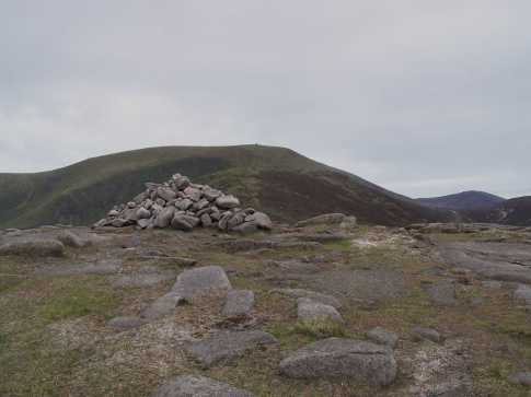
Picture: Priceless scenery
Diamonds aren't always a girl's best friend
by kernowclimber
1 Sep 2010
A steep climb up a series of steps (ouch) from the Hare's Gap to the summit of Slievenaglogh rewards the climber with incredible views over Slieve Bearnagh, Slieve Meelmore and Ben Crom Reservoir. I didn't see any diamonds (not counting the three intrepid souls who, like me, braved this last summit after having been put through our paces by the nimble and very lithe Bleck Cra on Scavvy IV), but the granite weathered and eroded into skeletal-like fingers near the summit was pretty amazing. I never was much for diamonds anyway. Give me a view like this any day... Linkback: mountainviews.ie/summit/304/comment/6076/
Read Less
Read More
tsunami on Slievenaglogh
by tsunami
5 Jun 2005
People disregard Slievenaglogh generally because of its lack of height and challenge to the seasoned hillwalker. But, there is more to keep you interested on this little summit than on many bigger peaks. For one, it is another one of those fantastic windows to the past which the Mournes like to throw at us - much like Meelmore, Donard and the Analong Valley, there is abundant evidence of the work of the mourne stone mason , none more so than a wonderful couple of millstones which never quite made it to the mills despite the obvious hours of effort put into their creation. I say two because I've been told there are - as yet I have only located one (if anyone knows plaes inform me!). The pic shows how Slievenaglogh is a very nice approach to Commedagh especially on the north side of the wall (one of the many mourne wall stiles has been placed just below the summit to make this option easier). Linkback: mountainviews.ie/summit/304/comment/1735/
Read Less
Read More
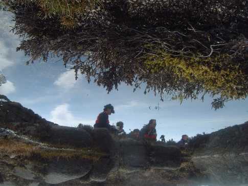
Picture: A Boggy Pool on Slievenaglogh
CaptainVertigo on Slievenaglogh
by CaptainVertigo
24 Apr 2005
What the Captain saw when he peered into a stagnant pool on Slievenaglogh on a warm Sunday afternoon in April 2005. Teeming with life, and a sample of Navan Hillwalkers feasting on sweetmeats, caviars and ham sandwiches. Linkback: mountainviews.ie/summit/304/comment/1659/
Read Less
Read More
Bleck Cra on Slievenaglogh
by Bleck Cra
20 Jan 2005
“Glogh!" It’s like the soft, liquid escape of some spit spirit. Slievenaglogh. From the Trassey or Annalong tracks, a Slieve-ish. From Commedagh and South of the wall, if you’re dreaming, you’ll miss it. North of the wall if you’re dreaming, your family will miss YOU. Last Sunday was a “why” day - blustering squalls and buckshot rain. “Why?” we grin manically, plodding knee-deep in black bog. A saunter off Commedagh for no good reason (like the saunter on) - sure you couldn’t see your eyes. A propos de fell runners …. there are some things I don’t get: mountain biking (up the way) heads the list, a woman witnessed pushing a pram up Beinn Lomond comes a close second, walking poles fight for third and fell running …... To be honest, it irks me that I’ll never be up to it, as long as there’s French wine and Italian food. But so many grey, drawn faces and the conviction that gravity CAN and WILL be beaten. The only boy beats gravity is Mr Crow and one day you may meet for dinner. But to Slieve of the Glogh. Little to make song and dance about, other than the fabulous Diamond Rocks - one of these odd Mournes volcanic pillar jobs, like the Castles on Commedagh and the Back Castles on Binnian, ‘cept this time underfoot! On a fat, lazy, confident ridge, they come as a complete shock and if you’re snoozing, will give you wobbly legs. Suddenly soft moss and indolent burnt bog defer to precipitous breath-taking drops and you have to shake the lemming genes out of your system. There are various ways off her, but clatter on to Hares Gap, this time South of the wall or you’ll join the diners therein….., from above. Linkback: mountainviews.ie/summit/304/comment/1429/
Use of MountainViews is governed by conditions and a privacy policy.
Read general information about the site. Opinions in material here are not necessarily endorsed by MountainViews.
Hillwalking is a risk sport. Information in comments, walks, shared GPS tracks or about starting places may
not be accurate for example as regards safety or access permission. You are responsible for your safety and your permission to walk.
See the credits and list definitions.


 Our Facebook page.