Cookies.
This website uses cookies, which are small text files that the website puts on your device to facilitate operation. Cookies help us provide a better service to you. They are used to track general user traffic information and to help the website function properly.
Features
Nearby features appear when you click the map.
Declutter tracks on map.
Place Search
Video
X
Pub: by
Galty Mountains Area , E: East Galtys Subarea
Feature count in area: 24, by county: Tipperary: 18, Limerick: 8, of which 2 are in both Limerick and Tipperary, OSI/LPS Maps: 66, 74, EW-G
Highest Place: Galtymore 917.9m

Starting Places (19) in area Galty Mountains:
Aherlow House Hotel, Annaslinga, Attychraan Loop Trail, Cahirabbey Upper, Carrigeen, Clydagh Bridge, Combaun Woods CP, Combaun Woods Track, Galtyway Climb Black Rd, Glengarra Woods, Kilmoyler Railway Boreen, Kings Yard, Lake Muskry Trailhead, Lissantrelick Paradise Hill, Lisvernane, Pigeonrock Behanagh Rivers fork, Scaragh Reservoir, Scarragh Wood S, Scarragh Wood W

Summits & other features in area Galty Mountains:
Cen: Central Galtys: Cush 641.2m, Galtybeg 799.2m, Galtymore 917.9m, Greenane 801.3m, Greenane West 787m, Knockastakeen 581.6m, Knockeenatoung 601.3m, Lough Curra Mound 600.4m, Seefin 446.6m, Seefin North Top 444.1m
E: East Galtys: Laghtshanaquilla 629.4m, Laghtshanaquilla North-East Top 598m, Slieveanard 437.8m, Slieveanard NE Top 448.5m, Sturrakeen 541.7m
N: North Galtys: Slievenamuck 369m
W: West Galtys: Benard 479.5m, Carrignabinnia 822.9m, Knockaterriff 691.6m, Knockaterriff Beg 679.3m, Lyracappul 824.9m, Monabrack 630.1m, Slievecushnabinnia 774.8m, Temple Hill 783.1m

Note: this list of places may include island features such as summits, but not islands as such.
Rating graphic.
Laghtshanaquilla, 629.4m Mountain Leacht Sheanchoille A name in Irish,
Place Rating ..
(poss. Ir. Leacht Sheanchoille [PDT], 'burial monument of the old
wood')
, Monavane, Tipperary County in Munster province, in Arderin, Vandeleur-Lynam Lists, Laghtshanaquilla is the 239th highest place in Ireland.
Grid Reference R95121 25063, OS 1:50k mapsheet 74
Place visited by: 214 members, recently by: rhw, jackos, MartMc, davidrenshaw, Prem, Carolineswalsh, markwallace, SeanPurcell, ConMack23, Tuigamala, ToughSoles, conorjob, jollyrog, Moirabourke, Cunn2000
I visited this place: NO (You need to be a logged-in member for this.)
Longitude: -8.072374, Latitude: 52.377561, Easting: 195122, Northing: 125064, Prominence: 36m,  Isolation: 0.8km
ITM: 595072 625114
Bedrock type: Conglomerate & purple sandstone, (Slievenamuck Conglomerate Formation)
Notes on name: This peak is unnamed on the Discovery map. There is a cairn near the summit, which could be the leacht in question. Previously Greenane East in MV.
  Short or GPS IDs, 6 char: Lghtsh, 10 char: Lghtshnql

Linkback: https://mountainviews.ie/summit/228/
Gallery for Laghtshanaquilla (Leacht Sheanchoille) and surrounds
Summary for Laghtshanaquilla (Leacht Sheanchoille): Bog and heather
Summary created by jackill 2011-12-09 08:31:20
Park at Scara S (R974 209) which is a forest entrance on the side of the main road between Cahir and Mitchelstown, room for 3 cars.Cross the barrier and follow the track through the forest going left then left again and across a sheepwire fence out on to the open hillside. The track marked on the OS 1:50000 map has stone walls on both sides however its after disappearing into the bog in many places and it is advisable to walk along the edge of it rather than on the track itself. This track leads all the way to the summit.
Linkback: mountainviews.ie/summit/228/comment/4988/
Member Comments for Laghtshanaquilla (Leacht Sheanchoille)
Comment create / edit display placeholder

            MountainViews.ie picture about Laghtshanaquilla (<em>Leacht Sheanchoille</em>)
Picture: From the Safety of 597
An Unworthy Thought
by CaptainVertigo 23 Dec 2014
An American guest was reclining on our couch some years ago when I rushed in to catch the Nine O'Clock News on the TV. She sat up and stared for a few moments. I thought she was reacting to a threatened change in wholesale interest rates, but I was wrong.
"She wouldn't be allowed on our TV" she said disapprovingly.
"Hard to listen to " I said pandering to what I thought was some kind of reaction to the perceived lefty politics of the presenter, "RTE is dominated by the Unions"
"No" she said "People who LOOK like that don't get on American TV"
She meant that the presenter was neither a Ken nor a Barbie. The presenter was a totally normal Irish person, the sort you'd meet at the supermarket checkout.
I was mildly amused to think that Americans should require their TV folk to be physically perfect notwithstanding the imperfection of the population at large, so to speak.
And that is why I checked myself the other day when the thought entered my head:
"How did this lump Laghtshanaquilla ever get into one of our lists?" It seemed to be merely a wobble of bog. Now that brief unworthy thought was born of a wild December day, hours before the solstice, when the northern earth enters its dark night of the soul. I will admit that I harboured this condescending notion for some minutes, and in that spirit of negativity I crept behind the rocky outcrop at Point 597 and photographed Laghtshanaquilla through the conglomerate stacks, making sure that the stone dominated the scene.
I have no doubt that I will see things differently in June Linkback: mountainviews.ie/summit/228/comment/17764/
Read Less
Read More

            MountainViews.ie picture about Laghtshanaquilla (<em>Leacht Sheanchoille</em>)
jackill on Laghtshanaquilla
by jackill 14 Mar 2005
I decided to approach this mountain from Scara S (R974 209) which is a forest entrance on the side of the main road between Cahir and Mitchelstown.I followed the track through the forest and across a sheepwire fence out on to the open hills. The track marked on the map has stone walls on both sides however its after disappearing into the bog in many places and it is advisable to walk along the edge of it rather than on the track itself. This track leads all the way to the summit. The photo is from the summit (which on review, I took GPS co-ords of A (R95121 25070) for) looking across to Sturrakeen with Slieveanard behind. In the distance you can make out Slievenamon in the centre and the Knockanaffrin ridge of the Comeraghs on the right. A good walk to give you a new perspective on the well walked Galtys. Linkback: mountainviews.ie/summit/228/comment/1524/
Read Less
Read More

Laghtshanaquilla a mountain worth naming!
by YoungJohn 2 Jun 2010
I took the second exit for Cahir heading south on the M8. I took the old N8 passed the firing range and the bridge over the Kilcoran river before turning right at the crossroads.
I passed a B&B and the road turned to track, I stayed going until a sheep pen where the track veered sharp left into forestry. I followed the track until a new mast (in the usual sitka spruce) where I parked. I walked back eastwards to a crossroads in the forestry where I turned left uphill. I went to the end of the track where I crossed over a low wire fence.
There I found a rough track which I followed downhill to a sheep enclosure. This is when I saw the sheep pen I had passed enroute to the mast! I followed this rough track, which was sludgy to say the least, along the forestry until its end.
I had, on several occasions, need to go on its 'banks' as there was water lying on it. I followed the Kilcoran river staying to its west side before I branched along sheep tracks to the slopes of Laghtshanaquilla. I went uphill through heather, fraughan bushes and rushes via sheep tracks. When the ground got hard underfoot,the going got lighter and I headed basically straight for the summit.
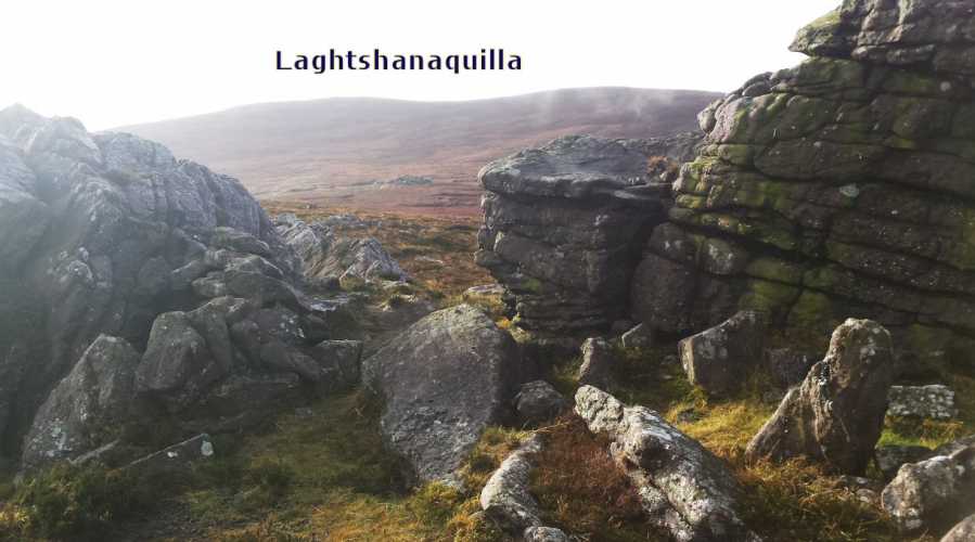
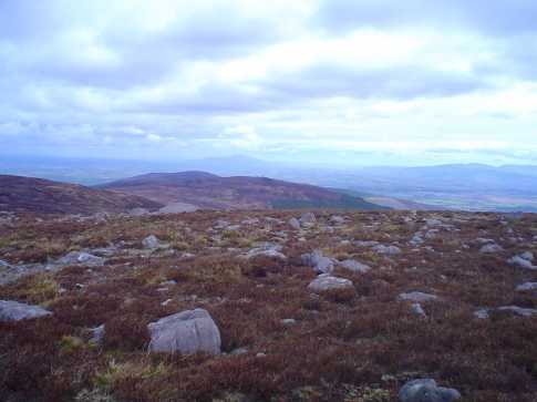
I found a cairn shy of the summit and thought it a bit small but didn't delay as I headed to the rock strewn summit. The rocks were conglomerate of stone. I had a well deserved tea break and took in the wonderous views of many mountain ranges and vales. The Knockmealdowns and the famous 'V' were clear though cloud cover was building south of them, The Comeraghs leading on tto Slievenamon and behind it the Blackstairs before the Slieve Ardagh hills before the Slievebloom way to the north heading back to the Devil's Bit range where Knockanora lead on to the three sisters of Knockadigeen, Ballincurra and Coneen before Keeper rose 'monarch' like to the Slieve Felims.
I could see dark clouds gathering over the high Galtys so I cut short my rest with a last view of the Blackwater valley. I checked the OSI map but could find no name for the mountain. I took a few snaps and headed for Sturrakeen along a ridge of sorts beside an old walled road/lane.
A grand mountain, thanks to MV for naming it. Linkback: mountainviews.ie/summit/228/comment/5850/
Read Less
Read More

sinbadw on Laghtshanaquilla
by sinbadw 5 Aug 2004
A fairly unremarkable hill, I took a gps reading at what I felt was the summit. The coordinates from this site seemed to be pointing to a lower hill a short distance to the south which does have a cairn (marked on OS map 74) at it's summit. Linkback: mountainviews.ie/summit/228/comment/1049/
Read Less
Read More
EDIT Point of Interest
text
Videos
Recent Contributions
x
Conditions and Info
Use of MountainViews is governed by conditions and a privacy policy.
Read general information about the site.
Opinions in material here are not necessarily endorsed by MountainViews.
Hillwalking is a risk sport. Information in comments, walks, shared GPS tracks or about starting places may not be accurate for example as regards safety or access permission. You are responsible for your safety and your permission to walk.
See the credits and list definitions.

OSi logo
OSNI/LPS logo
Open Street Map
(Various variations used.)
British summit data courtesy:
Database of British & Irish Hills