This website uses cookies, which are small text files that the website puts on your device to facilitate operation. Cookies help us provide a better service to you. They are used to track general user traffic information and to help the website function properly.
Feature count in area: 102, all in Mayo,
OSI/LPS Maps: 22, 23, 24, 30, 31, 37, 38, CBE, CBW, EW-ACC
Highest Place: Inishturk 189.3m
Starting Places (43) in area Mayo Islands: Bundorragha Estuary Cross, Bunnageeha, Bunnahowna Bridge, Bunnahowna River, Burrishoole Loop, Cartron River, Delphi Resort, Dernasliggaun, Erris Head, Fee Lough SW, Foher, Furnace Lough E, Glencraff Road End, Glendahurk Bridge, Illaunroe North, Illaunroe South, Inisturk, Killary Boat Tour Pier W, Leenane Hotel, Lettergesh Beach, LFeeagh E Treenbeg Cottage, Lough Fee East, Lough Feeagh, Lough Gall, Minaun Mast, Muck Lough NW, Mulranny Post Office, Murrisk Fishermans Monument, Nambrackkeagh Lough, National Famine Memorial, Owengar Bridge, Owenwee River, Portacloy Bay, Proesoon, Prospect Lough Road, Rossnafinna Island, Sean Scoil an Talaimh Bháin, Silver Strand Road, Skeaghatimull, St Patricks Church, Termon Hill Road, Tobercolman Cross Cemetery, Tower Hill South
Summits & other features in area Mayo Islands: An Teach Beag 84m, An tOighean 78m, Annagh Island (2) 23m, Annagh Island (1) 14m, Ballybeg 5m, Barranagh Island 7m, Bartragh Island 26m, Bills Rocks 5m, Black Rock (3) 71m, Caher Island 5m, Calf Island (2) 25m, Carraig na Faola 45m, Carrickawilt 9m, Carrickmoylenacurhoga 10m, Carricknaglamph 16m, Carricknaweelion 20m, Carrigee 11m, Clynish 42m, Collan Beg 25m, Collan More 46m, Cone Island South 15m, Crovinish 23m, Derrinish 21m, Dorinish Beg 15m, Dorinish More 25m, Dún Briste 50m, Duvillaun Beg 14m, Duvillaun Mór 60m, Eagle Island 55m, Erris Head Island 55m, Finnaun Island 5m, Freaghillan East 13m, Freaghillan West 19m, Frehil Island 17m, Gaghta Island 8m, Govern island 10m, Heath Island 5m, Horse Island (2) 25m, Illanambraher 25m, Illanataggart 28m, Illanballa 5m, Illancroagh 8m, Illanmaw 15m, Illannaconney 13m, Inishaghoo 14m, Inishbee 29m, Inishbiggle 34m, Inishbollog 18m, Inishcannon 25m, Inishcarrick 21m, Inishcooa 27m, Inishcoragh 24m, Inishcorky 14m, Inishcuill 26m, Inishdaff 31m, Inishdalla 5m, Inishdasky 31m, Inishdaugh 23m, Inishdeashbeg 15m, Inishdeashmore 19m, Inishdegil Beg 12m, Inishdegil More 32m, Inishdoonver 26m, Inisheeny 22m, Inisherkin 30m, Inishfesh 26m, Inishgallon 45m, Inishglora 22m, Inishgort (1) 29m, Inishgowla 28m, Inishgowla South 21m, Inishilra 18m, Inishimmel 15m, Inishkea North 24m, Inishkee 26m, Inishlaghan 5m, Inishlaughil 43m, Inishleague 27m, Inishlyre 26m, Inishmolt 16m, Inishnacross 36m, Inishoo 29m, Inishquirk 44m, Inishraher 33m, Inishturk (1) 189.3m, Inishturkbeg 51m, Inniscottle Island 26m, Island More 42m, Kid Island 86m, Knocknaskea (Inishkea South) 72m, Leamareha 7m, Moynish More 37m, No Name Island 8m, Pig Island (1) 55m, Roeillaun (1) 30m, Rosbarnagh Island 37m, Rosmore Island 28m, Rossnafinna Island 5m, Rusheen Island 9m, Shanvallybeg 20m, Stags of Broadhaven (central) 97m, Stags of Broadhaven South 94m
Note: this list of places may include island features such as summits, but not
islands as such.
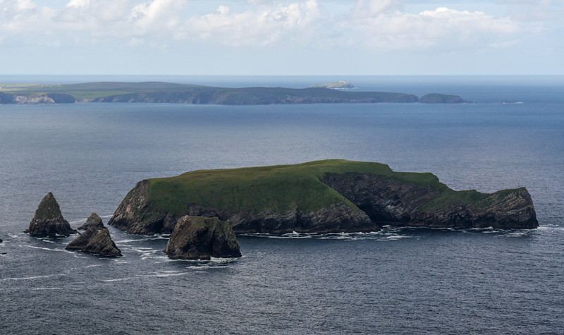
Kid Island, 86mIsland Oileán Mionnán A name in Irish,
Place Rating ..
, Mayo County in Connacht province, in Irish Islands Lists Reachable "On Foot " N Grid Reference F78700 43700,
OS 1:50k mapsheet 22 Place visited by: 3members, recently by: tphase, bryanjbarry, DavidWalsh, Island visited by 3 members.
I visited this place: NO (You need to be a logged-in member for this.)
Use of MountainViews is governed by conditions and a privacy policy.
Read general information about the site. Opinions in material here are not necessarily endorsed by MountainViews.
Hillwalking is a risk sport. Information in comments, walks, shared GPS tracks or about starting places may
not be accurate for example as regards safety or access permission. You are responsible for your safety and your permission to walk.
See the credits and list definitions.


 Our Facebook page.