This website uses cookies, which are small text files that the website puts on your device to facilitate operation. Cookies help us provide a better service to you. They are used to track general user traffic information and to help the website function properly.
Feature count in area: 60, all in Donegal,
OSI/LPS Maps: 1, 10, 11, 12, 13, 2, 3, 6, 7
Highest Place: Gull Island 95m
Starting Places (19) in area Donegal Islands: Altawinny Bay Road, Burtonport Pier, Cnoc Fola Carpark, Coshia, Crockadillisk Bend, Crocknamarrow, Cruit Golf Pier, Doherty's Dún, Five Fingers Strand, Glasagh Road, Glassagh Beach, Gola Island Ferry Pier, Mevagh Cross, Mullagh, Port Pier, Stella Maris Meevagh, Teach Dixon, Trá na Rossan, Trá na Rossan Hostel
Summits & other features in area Donegal Islands: Allagh Island 8m, An Bhuidéal 45m, An tOileán leathan 20m, Bo Island 13m, Calf Island (1) 5m, Cruit Island 32m, Edernishree 11m, Edernish 11m, Eighter Island 24m, Fall Island 11m, Gola Island 68m, Garvan Isles Green Isle 16m, Garvan Isles Middle Isle 5m, Garvan Isles White Isle 5m, Glashedy Island 35m, Go Island 5m, Gull Island 95m, Illanarva 5m, Illancarragh 20m, Illancrone SE 5m, Illannanaff 11m, Illanngall 23m, Iniscoo 15m, Inishal 6m, Inishbarnog 16m, Inishbeg 22m, Inishbofin (1) 33m, Inishcoole 13m, Inishdooey 38m, Inishduff 22m, Inisheane 5m, Inishfree Lower 25m, Inishfree Upper 14m, Inishillintry 21m, Inishinny (1) 27m, Inishinny (2) 16m, Inishkeel 19m, Inishkeeragh (1) 6m, Inishmeal 5m, Inishmeane 33m, Inishsirrer 23m, Inishtrahull 49m, Island Reagh 12m, Island Roy 15m, Mullaghtan 10m, Duck Island (1) 5m, Rathlin O'Birne Island 26m, Roaninish 9m, Rutland Island 20m, Tor Beg 5m, Torglass 25m, Tor More 35m, Toralayden 84m, Torhonadoogha 20m, Tornacolpagh Island 21m, Tory Island 83m, Tramore Point 5m, Tullyillan 11m, Tullavane Island 5m, Umfin Island 42m
Note: this list of places may include island features such as summits, but not
islands as such.
Tory Island, 83mIsland Toraigh A name in Irish,
Place Rating ..
, Donegal County in Ulster province, in Irish Islands Lists Reachable "On Foot " Y Grid Reference B87700 46100,
OS 1:50k mapsheet 1 Place visited by: 23members, recently by: miriam, adam.mann, Fergalh, sarahryanowen, bryanjbarry, pdtempan, mrmikelennon, jlk, Lauranna, eflanaga, rgctobin, Aongus, dregishjake, dregish, groe, Island visited by 43 members.
I visited this place: NO (You need to be a logged-in member for this.)
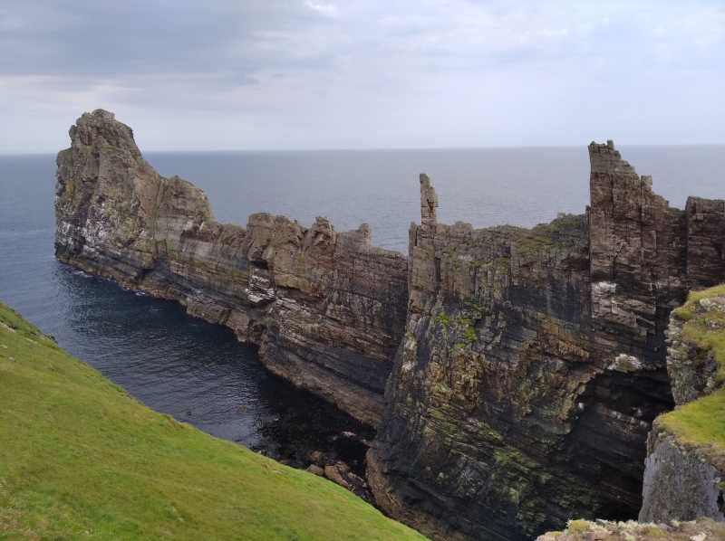
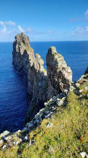
Alongside Dún Baloir there is the remarkable feature called Tor Mór (which is also known as the Key). This very narrow knife edge is one most adventurous scramblers may think twice about climbing ! Linkback: mountainviews.ie/island/2020/comment/23613/
Read Less
Read More
Picture: View from Dún Bhaloir
An isolated hidden gem...Off the coast worth the effort
by Fergalh
16 Aug 2022
Ireland's most isolated Island is 13.5 km from the coast, of Donegal. We got early ferry at 9 am, which takes around one hour. Arrived as the rain stopped fortunately and headed for a loop around the Lighthouse and Derek Hill's Hut. The loop walk will eventually lead you back to the capital. Than a few km east will lead you onto Dún Bhaloir the fort of the warrior of Celtic legend with the evil eye. Fortunately for us he was on his holidays and was not home !
The fort of Balor gives wonderful sweeping views of the cliffs from here. The round trip of the whole island is around 13.5 km, giving plenty of time for a drink at the hotel whilst waiting for the evening ferry back at 5.30 PM Linkback: mountainviews.ie/island/2020/comment/23612/
Read Less
Read More
Picture: Tory with its Crosses and Balors Fort on the East
Tory is a must see island
by seamusdoohan
5 Oct 2022
Fantastic place for a hike ...get off the Ferry and head East to Balors Fort... dramatic sea cliffs and sea stacks... also good if you can doeak a Cúpla focal ....also brilliant for those interested in Archaeology... basin stones, high tower , Tua Cross and other early Christian Cross.... enjoy Linkback: mountainviews.ie/island/2020/comment/23681/
Read Less
Read More
Good walking around the Cliffs on Tory, a bonus to see the Puffins.
Use of MountainViews is governed by conditions and a privacy policy.
Read general information about the site. Opinions in material here are not necessarily endorsed by MountainViews.
Hillwalking is a risk sport. Information in comments, walks, shared GPS tracks or about starting places may
not be accurate for example as regards safety or access permission. You are responsible for your safety and your permission to walk.
See the credits and list definitions.


 Our Facebook page.