This website uses cookies, which are small text files that the website puts on your device to facilitate operation. Cookies help us provide a better service to you. They are used to track general user traffic information and to help the website function properly.
Feature count in area: 60, all in Donegal,
OSI/LPS Maps: 1, 10, 11, 12, 13, 2, 3, 6, 7
Highest Place: Gull Island 95m
Starting Places (19) in area Donegal Islands: Altawinny Bay Road, Burtonport Pier, Cnoc Fola Carpark, Coshia, Crockadillisk Bend, Crocknamarrow, Cruit Golf Pier, Doherty's Dún, Five Fingers Strand, Glasagh Road, Glassagh Beach, Gola Island Ferry Pier, Mevagh Cross, Mullagh, Port Pier, Stella Maris Meevagh, Teach Dixon, Trá na Rossan, Trá na Rossan Hostel
Summits & other features in area Donegal Islands: Allagh Island 8m, An Bhuidéal 45m, An tOileán leathan 20m, Bo Island 13m, Calf Island (1) 5m, Cruit Island 32m, Edernishree 11m, Edernish 11m, Eighter Island 24m, Fall Island 11m, Gola Island 68m, Garvan Isles Green Isle 16m, Garvan Isles Middle Isle 5m, Garvan Isles White Isle 5m, Glashedy Island 35m, Go Island 5m, Gull Island 95m, Illanarva 5m, Illancarragh 20m, Illancrone SE 5m, Illannanaff 11m, Illanngall 23m, Iniscoo 15m, Inishal 6m, Inishbarnog 16m, Inishbeg 22m, Inishbofin (1) 33m, Inishcoole 13m, Inishdooey 38m, Inishduff 22m, Inisheane 5m, Inishfree Lower 25m, Inishfree Upper 14m, Inishillintry 21m, Inishinny (1) 27m, Inishinny (2) 16m, Inishkeel 19m, Inishkeeragh (1) 6m, Inishmeal 5m, Inishmeane 33m, Inishsirrer 23m, Inishtrahull 49m, Island Reagh 12m, Island Roy 15m, Mullaghtan 10m, Duck Island (1) 5m, Rathlin O'Birne Island 26m, Roaninish 9m, Rutland Island 20m, Tor Beg 5m, Torglass 25m, Tor More 35m, Toralayden 84m, Torhonadoogha 20m, Tornacolpagh Island 21m, Tory Island 83m, Tramore Point 5m, Tullyillan 11m, Tullavane Island 5m, Umfin Island 42m
Note: this list of places may include island features such as summits, but not
islands as such.
Inishcoole, 13mIsland Inis Cùil A name in Irish,
Place Rating ..
(Ir. Inis Cùil [logainm.ie], 'island of the corner/nook') Skull Island an extra name in English, Donegal County in Ulster province, in Irish Islands Lists Reachable "On Foot " Y Grid Reference B79900 24300,
OS 1:50k mapsheet 1 Place visited by: 7members, recently by: Fergalh, magicstep, dregish, finkey86, GoldCircle, bryanjbarry, DavidWalsh, Island visited by 7 members.
I visited this place: NO (You need to be a logged-in member for this.)
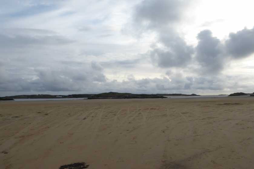
Picture: It's that rocky mass to the front and centre
When the tide's out, it's a lovely amble
by GoldCircle
30 Jul 2019
This small island is in a tidal estuary and is comfortably accessible with dry feet at low tide - a mere 5 minute stroll. A vast expanse of golden sand opens up at low water and the highlight of this beach is the wreck of Bád Eddie - a now badly decayed hull of a large wooden boat.
The island itself is unremarkable, having maram grasses and myriad wild flowers - and a few tracks around.
The peace is only disturbed by the occasional Aer Lingus plane on final approach to nearby Donegal Airport and the occasional yob doing donuts on the sand in souped-up cars. Linkback: mountainviews.ie/island/2006/comment/20592/
Use of MountainViews is governed by conditions and a privacy policy.
Read general information about the site. Opinions in material here are not necessarily endorsed by MountainViews.
Hillwalking is a risk sport. Information in comments, walks, shared GPS tracks or about starting places may
not be accurate for example as regards safety or access permission. You are responsible for your safety and your permission to walk.
See the credits and list definitions.


 Our Facebook page.