This website uses cookies, which are small text files that the website puts on your device to facilitate operation. Cookies help us provide a better service to you. They are used to track general user traffic information and to help the website function properly.
Feature count in area: 27, all in Galway,
OSI/LPS Maps: 37, 38, 44, 45, EW-CON
Highest Place: Binn idir an dá Log 702m
Starting Places (42) in area Maamturks: An Móinín Mór, Bealanabrack River Tributary, Bundorragha Estuary Cross, Cannaclossaun, Carraig Bar, Connemara Mountain Hostel, Delphi Resort, Dernasliggaun, Drehidanookera Bridge, Failmore River, Fee Lough SW, Glashmore Bridge, Glencraff Road End, Gleninagh River, Gowlaunlee Lake, Illaunroe South, Killary Boat Tour Pier W, Knocknafaughy SW, Kylemore River, Leenane, Leenane Hotel, unuseableLeenane R336, Lehanagh Lough N, Lehanagh Lough SE, Lough Fee East, Lough Nacarrigeen S, Lough Shindilla S, Maum Bridge Road Lower, Maum Bridge Road Mid, Maum Bridge Road Upper, Maumwee Lough, Nambrackkeagh Lough, Oorid Lough, Owenwee River, Pas Mám Éan CP, Rinavore East, Rinavore SW, Shanvally, Tawnabeg Lough North, Tooreennacoona River, Western Way Cnoc na hUilleann, Western Way Inagh Cottages
Summits & other features in area Maamturks: N: Leenaun: Maumturkmore 488m, Búcán 550m, Leenaun Hill 618m, Leenaun Hill Far North-West Top 556m, Lettershanbally 324m, Meall Cheo 578m, Taobh Dubh 422m N: Maumturks N Cen: Barrlugrevagh 558m, Letterbreckaun 667m, Letterbreckaun NE Top 603m, Knocknahillion 607m, Knocknahillion North Top 541m, Cúlóg 435m S: Maumturks S Cen: Binn Chaonaigh 633.5m, Binn idir an dá Log 702m, Binn idir an dá Log SE Top 659.3m, Binn Mhairg 612.4m, Knocknagur 310m S: Maumturks South: Binn Mhór 660.6m, Binn Mhór NE Top 641.2m, Binn Mhor West Top 595.8m, Binn Mhor East Top 631.3m, Lissoughter 401m, Corcogemore 610.1m, Mullach Glas NE Top 432m, Lackavrea 396m, Mullach Glas 621.3m
Note: this list of places may include island features such as summits, but not
islands as such.
Barrlugrevagh, 558mMountain Barr Log Riabhach A name in Irish,
Place Rating ..
loganim, Top of the streaked ,grey hollow, Barr Log Gríobhach, Galway County in Connacht province, in Arderin Beg, Irish Best Hundred Lists, Barr Log Riabhach is the 400th highest place in Ireland.
Grid Reference L86527 54790,
OS 1:50k mapsheet 37 Place visited by: 108members, recently by: TipsyDempy, Blackstar, maoris, Prem, Carolineswalsh, NualaB, Moirabourke, abeach, Krzysztof_K, farmerjoe, learykid, adam.mann, nupat, Krumel, Beti13
I visited this place: NO (You need to be a logged-in member for this.)
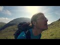
If coming from the south note that the first cairned summit reached isn't the top. The true summit has its cairn not quite on the top and immediately beyond it you plunge back into the quartzite wilderness. Descending westwards from the col between the summit and Letterbreckaun involves negotiating bands of quartzite slabs, steep and exposed in places. Sheep tracks zigzag through, but still imvolve moves of the "do not fall here" variety. There is any amount of slabby scrambling here for an ascent on a nice sunny day. Linkback: mountainviews.ie/summit/1501/comment/20077/
Use of MountainViews is governed by conditions and a privacy policy.
Read general information about the site. Opinions in material here are not necessarily endorsed by MountainViews.
Hillwalking is a risk sport. Information in comments, walks, shared GPS tracks or about starting places may
not be accurate for example as regards safety or access permission. You are responsible for your safety and your permission to walk.
See the credits and list definitions.


 Our Facebook page.