This website uses cookies, which are small text files that the website puts on your device to facilitate operation. Cookies help us provide a better service to you. They are used to track general user traffic information and to help the website function properly.
Feature count in area: 58, all in Down,
OSI/LPS Maps: 20, 29, EW-CLY
Highest Place: Slieve Donard 849m
Starting Places (33) in area Mourne Mountains: Alex Steddom Tree, Aughrim Airstrip, Ben Crom Dam, Bloody Bridge Car Park, Carlingford Greenway, Carrick Little, Crocknafeola Wood, Crotlieve Mountain, Donard Car Park Newcastle, Drummanmore Picnic, Fofanny Reservoir, Forest Office CP, Gamekeepers Lodge CP, Happy Valley Trassey Rd, Hen Mountain CP, Leitrim Lodge CP, Mayo Road Corner, Meelmore Lodge, Newcastle Harbour, Ott CP, Red Bog Road, Rourkes Park, Sandy Brae, Silent Valley Reservoir Head Rd, Slieve Donard Trail Head, Slieve Foye Viewing Point, Slievefoy Forest CP, Spelga Dam E, Spelga Dam N, Spelga Dam S, Trassey Car Park, Two Mile River CP, Yellow Water Park
Summits & other features in area Mourne Mountains: Cen: Loughshannagh: Ben Crom 526m, Carn Mountain 585.2m, Carn Mountain North Top 553.7m, Doan 592.6m, Ott Mountain 526.8m, Slieve Loughshannagh 617m, Slieve Muck 670.4m, Slievenaglogh 445m E: Binnian: Slieve Binnian 745.9m, Slieve Binnian East Top 639m, Slieve Binnian North Top 678m, Slieve Binnian North Tor 682.5m, Wee Binnian 460m E: Donard: Chimney Rock Mountain 656m, Crossone 540m, Millstone Mountain 460m, Rocky Mountain 524m, Slieve Donard 849m E: Lamagan: Cove Mountain 654.8m, Slieve Beg 595.9m, Slievelamagan 702.2m N: Bearnagh: Slieve Bearnagh 739m, Slieve Bearnagh North Tor 680m, Slieve Meelbeg 701.9m, Slieve Meelmore 687m N: Castlewellan: Slievenalargy 280m, Slievenaslat 272m N: Commedagh: Slieve Commedagh 767m, Slieve Corragh 641.9m, Slievenaglogh 584.4m, Slievenaglogh East Top 571m N: Croob: Cratlieve 429m, Slieve Croob 534m, Slievegarran 391m, Slievenisky 446m N: Rathfriland: Knockiveagh 235m S: Kilkeel: Knockchree 306m S: Rostrevor: Crenville 460m, Finlieve 578m, Slievemartin 485m, Slievemeel 420m, Slievemeen 472m W: Hilltown: Gruggandoo 382m, Slieveacarnane 296m W: Slievemoughanmore: Crotlieve Mountain 347m, Eagle Mountain 638m, Rocky Mountain 404m, Shanlieve 626m, Slievemoughanmore 560m, Tievedockaragh 473m, Wee Slievemoughan 428m W: Spelga: Butter Mountain 500m, Cock Mountain 504m, Cock Mountain South-West Top 505m, Hen Mountain 354m, Pigeon Rock Mountain 534m, Pigeon Rock Mountain South Top 530m, Slievenamiskan 444m
Note: this list of places may include island features such as summits, but not
islands as such.
Cock Mountain South-West Top, 505mMountain Sliabh an Choiligh (mullach thiar theas) A name in Irish,
Place Rating ..
For origin of name, see Cock Mountain., Down County in Ulster province, in no lists, Cock Mountain South-West Top is the 558th highest place in Ireland.
Grid Reference J25200 26600,
OS 1:50k mapsheet 29 Place visited by: 101members, recently by: MickM45, abeach, Dee68, Carolineswalsh, Beti13, Alanjm, blessobilly, Mark1, Florence, Paddym99, garybuz, ElaineM76, Kirsty, TommyMc, annem
I visited this place: NO (You need to be a logged-in member for this.)
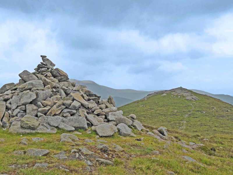
Picture: The SW top (right) as seen from its near neighbour.
Simplicity itself
by Colin Murphy
5 Jul 2021
Assuming you've bagged Cock Mountain itself, this is a breeze, as it is just 250m away to the south west. Despite it's closeness, the peak is well-defined in its own right and presents great vistas of the western Mournes. Linkback: mountainviews.ie/summit/1486/comment/23204/
Use of MountainViews is governed by conditions and a privacy policy.
Read general information about the site. Opinions in material here are not necessarily endorsed by MountainViews.
Hillwalking is a risk sport. Information in comments, walks, shared GPS tracks or about starting places may
not be accurate for example as regards safety or access permission. You are responsible for your safety and your permission to walk.
See the credits and list definitions.


 Our Facebook page.