This website uses cookies, which are small text files that the website puts on your device to facilitate operation. Cookies help us provide a better service to you. They are used to track general user traffic information and to help the website function properly.
Feature count in area: 62, by county: Cork: 45, Kerry: 24, of which 7 are in both Cork and Kerry,
OSI/LPS Maps: 78, 79, 85, 86, 88, 89
Highest Place: Knockboy 704.8m
Starting Places (47) in area West Cork Mountains: Barley Lake North, Barrboy, Caha Pass, Carranmore, Carrigacappeen, Carriganass Castle, Castle Donovan Car Park, Clearagh House, Coolkellure House, Coomhola Bridge, Corrigatirra, Cousane Gap, Cummer Lough East Road, Derreencollig Wood, Esk Boreen, Fuhiry Wood, Garinish Island Pier, Glasagarav River Bridge, Glasnacummeen Stream, Glengarriff, Glengarriff Nature Reserve CP, Gorteeniher Drimoleague Heritage Walk CP, Gortloughra River Road, Gougane Barra Oratory, Gougane Barra Park CP, Grousemount Wind Farm, Kealkill Village, Knockanuha, Knockbrack South, Lough Atooreen N, Lough Nambrackderg North, Lough Nambrackderg Wood, Lough Nambreacdearg, Mealagh Bridge, Molly Gallivan's Visitor Centre, Nowen Hill West Road, Owvane River Bridge, Pookeen North Top Road, Pooleen Wood Car Park, Priests Leap, Reenroe Bridge, River Roughty, Shandrum Concrete Silo, Sillahertane Stream, Slaheny River Horseshoe, Top of Coom, Turner's Rock Tunnel
Summits & other features in area West Cork Mountains: Cen: Maughanaclea: Maughanaclea Hills East Top 470m, Maughanaclea Hills West Top 452m Cen: Shehy More: Shehy More 545.6m, Shehy More SW Top 446m E: Clearagh: Clearagh Hill 287m E: Currane: Currane Hill 228m N Cen: Douce: Douce Mountain 476m, Doughill Mountain 471m N: Carran: Barnastooka 497m, Bealick 537m, Carran 604m, Carran Far NE Top 561m, Carran Far North Top 506m, Carran NE Top 555m, Carran South Top 567m, Knockantooreen 450m N: Conigar: Conigar 566m, Conigar SW Top 566m, Foilastookeen 540m N: Coomataggart: Carrigalougha 423m, Coomataggart 530m, Coomataggart SW Top 509m, Derrineanig 304m, Lackabaun 472m, Mweelin 487m NE Cen: Carrigarierk: Carrigarierk 343m NW: Barraboy: Barraboy Mountain 460m, Barraboy Mountain Far East Top 456m, Barraboy Mountain SE Top 409m, Derroograne 468m, Turners Rock 420m NW: Knockboy: Caoinkeen 692.8m, Caoinkeen South-East Top 553.5m, Coomhola Mountain 472m, Knockboy 704.8m, Knockboy North Top 651.2m, Knockboy South Top 533.3m, The Priest's Leap 519m NW: Knocknamanagh: Bird Hill 412m, Coomclogherane Top 449m, Gullaba Hill 603m, Knockbrack 440m, Knockbrack South Top 458m, Knocknamanagh 637m, Knocknamanagh NE Top 625m S Cen: Dunmanway Hills: Cashloura 296.8m, Coolsnaghtig 295.8m, Inchanadreen 310m S Cen: Nowen: Milane Hill 354.4m, Mullaghmesha 494.3m, Nowen Hill 535.2m, Nowen Hill Far West Top 405.2m, Nowen Hill SW Top 509m, Pookeen North Top 319m S: Leap Hills: Carrigfadda 311.7m, Killeigh Hill 229m, Knockarudane Hill 169m, Knockscagh 195m S: Skibbereen: Barryroe Hill 156m, Lick Hill 158m W Cen: Knockbreteen: Knockbreteen 239m W: Bantry: Knocknaveagh 282m
Note: this list of places may include island features such as summits, but not
islands as such.
Caoinkeen South-East Top, 553.5mMountain An Caincín (mullach thoir theas) A name in Irish,
Place Rating ..
For origin of name, see Caoinkeen., Cork County in Munster province, in Arderin Beg Lists, Caoinkeen South-East Top is the 414th highest place in Ireland.
Grid Reference W02815 63788,
OS 1:50k mapsheet 85 Place visited by: 44members, recently by: Petecal423, Leatra, Djouce, knightsonhikes, Lucy.boland, NualaB, a3642278, CusackMargaret, johncusack, Grumbler, nupat, annem, Colin Murphy, eiremountains, conrad1179
I visited this place: NO (You need to be a logged-in member for this.)
Short or GPS IDs, 6 char: CnknSt, 10 char: CnknSthEst Linkback: https://mountainviews.ie/summit/1437/
Gallery for Caoinkeen South-East Top (An Caincín (mullach thoir theas)) and surrounds
Summary
for Caoinkeen South-East Top (An Caincín (mullach thoir theas)):
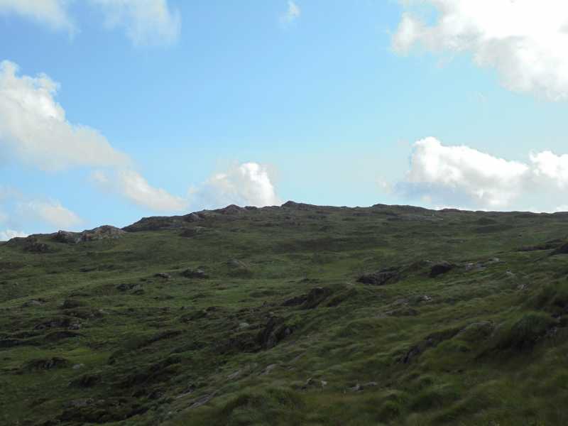
Approach from the north-east
Summary created by Colin Murphy
2022-06-20 10:37:24
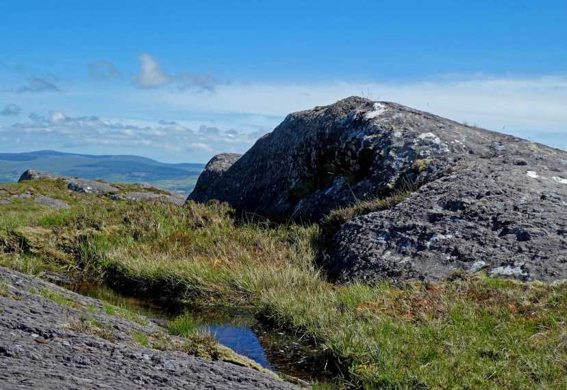
Picture: Summit boulder
There is parking for one or two (at a squeeze) cars at L N'breacdrg (W03922 64895), but be careful not to block access to the two gates. Proceed down the road that leads to Lough Nambrackderg and you will immediately see a rough track (muddy in parts) on your right, leading up the slope. Follow this until it peters out around A (W03237 64647) and then continue up and around the curve of the mountain in a S - SSW direction. The terrain is mostly grassy stretches among rocky outcrops. The summit is a large rounded outcrop. Fine views all around, particularly when the two loughs below are visible. Allow 2 hours up and down.
To the northeast of the summit, at a height of 263m, lies the pretty Lough Nambrackderg. A short walk taking in the summit and a circuit of the lake is possible from parking at L N'breacdrg (W03922 64895). Linkback: mountainviews.ie/summit/1437/comment/18207/
Read Less
Read More
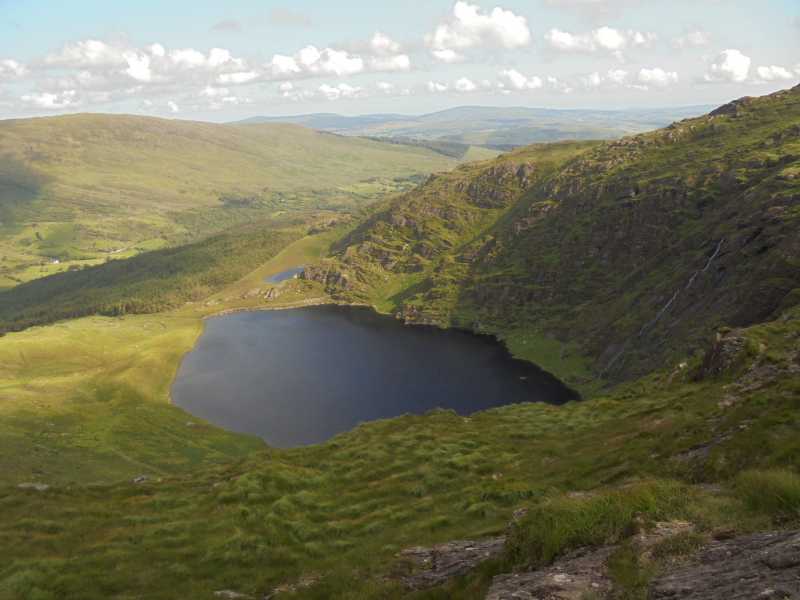
Picture: Lough Nambrackderg & Lough Beg
Scrambled legs
by thomas_g
12 Dec 2015
Onzy's comment had reminded me that I'd been meaning to do the circuit of Lough Nambrackderg for some time.
One route up is the spur between Lough Nambrackderg and Lough Beg which is a good scramble, with a few unprotected moves on slippery rock.
Other options from this side are the gully on the south side of Lough Nambrackderg which looked easy enough as gully climbs go and possibly the easiest option, the spur to the south of Lough Beg. Linkback: mountainviews.ie/summit/1437/comment/18405/
Read Less
Read More
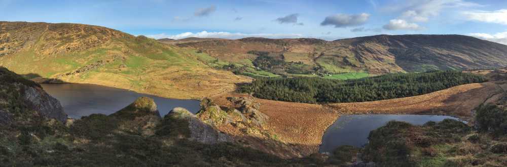
Picture: Cainkeen tops from Conigar.
Serious cliffs above Lough Nambrackderg
by simon3
6 Jun 2018
The Caoinkeens can be seen well from the vicinity of Conigar. Caoinkeen SE is to the left, the main summit to the right. Linkback: mountainviews.ie/summit/1437/comment/19941/
Read Less
Read More
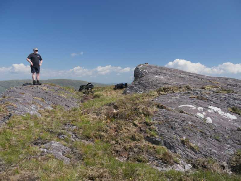
Picture: Rock sheep of the top.
The top
by simon3
1 Jul 2021
The top has this fine roche moutonnée. Ice has passed over the rock, smoothing to the right of the picture, plucking the highpoint shown in the centre. Much of the rock around the summit area is like this . great for resting out of the wind when it is coming from the right direction.
In this particular photo, we were surveying the height of the summit. Previously we had found a suitable candidate for the col between this summit and Caoinkeen so we can get a reasonably accurate prominence figure. Linkback: mountainviews.ie/summit/1437/comment/23199/
Read Less
Read More
Competing Summits
by Onzy
21 Jul 2015
Caoinkeen South East Top is easily reached from Caoinkeen itself. From the northeast, the summit looks almost like a ridge, with a number of prominences competing for the highpoint. The summit area itself however, is more plateau-like with three definite contenders for the honour, with B (W02812 63787) registering highest for me. Linkback: mountainviews.ie/summit/1437/comment/18206/
Use of MountainViews is governed by conditions and a privacy policy.
Read general information about the site. Opinions in material here are not necessarily endorsed by MountainViews.
Hillwalking is a risk sport. Information in comments, walks, shared GPS tracks or about starting places may
not be accurate for example as regards safety or access permission. You are responsible for your safety and your permission to walk.
See the credits and list definitions.


 Our Facebook page.