This website uses cookies, which are small text files that the website puts on your device to facilitate operation. Cookies help us provide a better service to you. They are used to track general user traffic information and to help the website function properly.
Feature count in area: 45, all in Donegal,
OSI/LPS Maps: 11, 6
Highest Place: Croaghgorm 674m
Starting Places (22) in area Bluestack Mountains: An Leathchruach, Barnsmore Gap, Bensons Hill, Caldragh CP, Clogher South peak, Cruach Mhín an Neanta, Doobin, Eanybeg Water Bridge, Edergole Farm, Gaugin Mountain, Glennacree CP, Hillhead, Lough Finn West, Lough Magrath Beg NE, Lough Muck North, Meenaguse Lough, Sand Lough Forest Picnic Area, Scoil Náisúnta an Choimín, Sheskinlubanagh, Sruell Gap Farm, Sruell River Road, St Columbkilles Well and Altar
Summits & other features in area Bluestack Mountains: Cen: Reelan Hills: Altnapaste 364m, Gaugin Mountain 565m, Lacroagh 403m, Boultypatrick 429m, Croveenananta 476m, Croaghubbrid 416m, Croaghugagh 410m N: Fintown Hills: Aghla Mountain South Top 589m, Aghla Mountain 593m, Scraigs 426m, Croaghleheen 385m NW: Glenties: Cloghercor South 301m, Derkbeg Hill 332m, Drumnalough Hill 282m S: Belshade: Croaghgorm 674m, Croaghgorm South-West Top 597m, Croaghgorm East Top 594m, Ardnageer 642m, Ardnageer SW Top 626m, Banagher Hill 392m, Croaghbane 641m, Croaghgorm Far South-West Top 561m, Cronamuck 444m, Croaghbarnes 498.8m, Glascarns Hill 578.3m, Meenanea 435m SE: Barnesmore: Brown's Hill 496.4m, Cloghervaddy 402m, Croaghagranagh 440m, Croaghanirwore 546.1m, Croaghbrack 401m, Croaghconnellagh 523m, Croaghnageer 569.1m, Croaghnageer East Top 543.5m, Croaghnageer North-East Top 521m, Croaghonagh 451m SW: Eany Beg Hills: Binbane 453m, Binbane NE Top 439m, Lavagh Beg 650m, Lavagh More 671m, Binnasruell 505m, Carnaween 521m, Cloghmeen Hill 429m, Silver Hill 600m, Cullaghacro 476m
Note: this list of places may include island features such as summits, but not
islands as such.
Croaghgorm Far South-West Top, 561mMountain Chruach Ghorm i bhfad siar ó dheas A name in Irish,
Place Rating ..
Lough Nacrow Mountain an extra name in English, Donegal County in Ulster province, in Arderin Beg Lists, Croaghgorm Far South-West Top is the 389th highest place in Ireland.
Grid Reference G93364 88650,
OS 1:50k mapsheet 11 Place visited by: 40members, recently by: abeach, gerrym, a3642278, Grumbler, dino, gdg, AlanReid, BleckCra, Djouce, annem, eamonoc, DSutherland, ilenia, eoghancarton, wicklore
I visited this place: NO (You need to be a logged-in member for this.)
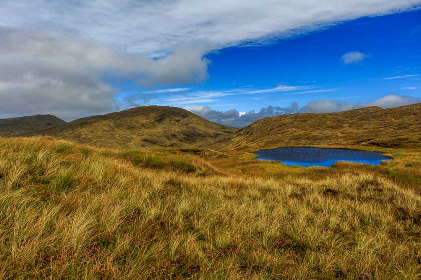
I got a very wet, windy day for this one, as I walked it from the Reelan Valley via Croaghgorm and the South West Top. By the time I got to the higher ground on Croaghgorm I had climbed into the clouds that had been raining on me from the start. As often happens, the mist around me cleared in seconds on the South West Top, and the sun intermittently broke through angry looking skies to throw patches of light on the landscape. It was ample reward tor my earlier efforts and allowed me to stick to my theory that you rarely, if ever regret venturing out regardless of the weather.
Use of MountainViews is governed by conditions and a privacy policy.
Read general information about the site. Opinions in material here are not necessarily endorsed by MountainViews.
Hillwalking is a risk sport. Information in comments, walks, shared GPS tracks or about starting places may
not be accurate for example as regards safety or access permission. You are responsible for your safety and your permission to walk.
See the credits and list definitions.


 Our Facebook page.