This website uses cookies, which are small text files that the website puts on your device to facilitate operation. Cookies help us provide a better service to you. They are used to track general user traffic information and to help the website function properly.
Sperrin MountainsArea, NW Cen: Glenelly North West
Subarea
Feature count in area: 64, by county: Derry: 34, Tyrone: 39, of which 9 are in both Derry and Tyrone,
OSI/LPS Maps: 12, 13, 6, 7, 8
Highest Place: Sawel 678m
Starting Places (21) in area Sperrin Mountains: Altinure Road, Banagher Glen Nature Reserve, Barnes Gap Car Park, Crocknakin, Drumnaspar Picnic CP, Glenchiel Road, Glenedra Bridge, Glenelly Road, Parkreagh, Goles Road, Lough Ouske, Moneyneany Village, Moydamlaght Forest, Moydamlaght Road, Mullaghmore, Mullaghbane, Spaltindoagh, Sperrin Hamlet, Sperrin Heritage Centre, Sperrin Heritage Centre W, Sperrin Road, Barnes Top, Sperrin Road, Glashagh Bridge, Sperrin Road, Sperrin
Summits & other features in area Sperrin Mountains: E: Magherafelt Hills: Slieve Gallion NE Top 493.6m E: Magherafelt Hills: Slieve Gallion 526.6m N: Claudy Hills: Crockdooish 321m, Curradrolan Hill 270m, Eglish 277m, Letterlogher 249m, Mullaghmeash Hill 244m, Slieveboy 259m, Straid Hill 303m NE Cen: Glenelly North East: Barnes Top 456m, Craigagh Hill 460m, Crockbrack 526.1m, Knockanbane Mountain 441m, Meenard Mountain 620m, Meenard Mtn W Top 480m, Mullaghaneany 627m, Mullaghash 480m, Mullaghsallagh 485m, Oughtmore 569m, Spelhoagh 568m NE: Glenshane North: Benbradagh 465m, Boviel Top 454m, Carn Hill 448m, Carntogher 464m, Moneyoran Hill 414m NE: Glenshane South: Bohilbreaga 478m, Coolnasillagh Mountain 423m, Corick Mountain 430m, Crockalougha 407m, Mullaghmore 550m, White Mountain 537m NW Cen: Glenelly North West: Dart Mountain 619m, Dart Mountain North-West Top 525m, Learmount Mountain 489m, Learmount Mountain South Top 492m, Mullaghasturrakeen 581m, Mullaghcarbatagh 517m, Mullaghclogha 635m, Mullaghclogher 572m, Mullaghdoo 568m, Sawel 678m NW: Maheramason Hills: Clondermot Hill 220m, Gortmonly Hill 218m, Slievekirk 370m SE Cen: Glenelly South East: Carnanelly 562m, Carnanelly West Top 503.4m, Mullaghbane 467m, Mullaghturk 416m SE: Cookstown Hills: Cregganconroe 300m, Fir Mountain 362m, Oughtmore 382m SW Cen: Glenelly South West: Clogherny Top 408m, Craignamaddy 385m, Crocknamoghil 335m, Mullaghbolig 442m, Spaltindoagh 420m SW: Mullaghcarn: Curraghchosaly Mountain 416m, Mullaghcarn 542m, Mullaghcarn South Top 525m SW: Newtownstewart Hills: Bessy Bell 420m, Mullaghcroy 242m W: Strabane: Balix Hill 403m, Knockavoe 296m, Owenreagh Hill 400m
Note: this list of places may include island features such as summits, but not
islands as such.
Mullaghdoo, 568mMountain
Place Rating ..
, Tyrone County in Ulster province, in Arderin Beg Lists, Mullaghdoo is the 370th highest place in Ireland.
Grid Reference H56879 96585,
OS 1:50k mapsheet 13 Place visited by: 59members, recently by: farmerjoe, Grumbler, Krzysztof_K, trostanite, Paddym99, garybuz, annem, osullivanm, abcd, Colin Murphy, Kilcoobin, Carolyn105, dregishjake, fellrunner, Haulie
I visited this place: NO (You need to be a logged-in member for this.)
Short or GPS IDs, 6 char: Mlghd, 10 char: Mullaghdoo Linkback: https://mountainviews.ie/summit/1423/
Gallery for Mullaghdoo and surrounds
Summary
for Mullaghdoo :
Unremarkable summit.
Summary created by Colin Murphy
2021-10-26 15:29:32
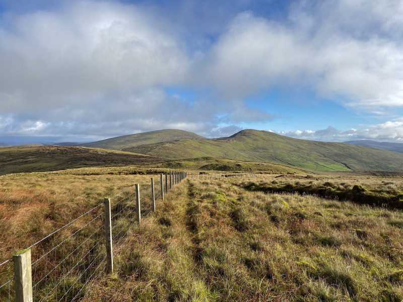
Picture: Sawel and Dart as seen from summit.
Parking for a few cars at A (H58955 96913). Cross the road and head up the initially steep, grassy slope of Learmount South Top. The slope becomes gentler but also boggier as you ascend the 800m or so to this point. From Learmount South turn SW for about 700m, passing though peat hags and heather, crossing multiple fences. This area is very boggy underfoot. From B (H579 966), turn directly west up a gradually rising slope for 1.5km. The terrain becomes more grassy as you ascend and somewhat easier to navigate. A fence runs the entire way to the top, which is a good aid in poor visibility. The summit is a flattish, grassy area and is unmarked.
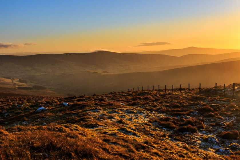
Picture: Sunset over the Glenelly Valley as I was making my way down again.
First Day Out Of The Year
by Aidy
2 Jan 2017
This one was added after I'd done the nearby summits, and as it is now one my local 100, I came back to tick it off too. Knowing the ground around here, and it being a short walk, I decided to wear the wellies instead of the hiking boots. I parked around A (H58955 96913) and the natural route seemed to be over the summit of Learmount Mountain S Top. The ground was frozen in most places, but I broke through the surface in parts that had been exposed to the sun for most of the day. I went deep enough into boggy muck at these times that if I had been wearing the boots, it would have come in over the top, so the wellies were a good choice.
Its a fairly easy walk, with the starting point being high up, and the round trip being only about 4 kilometers or so, but harder than these advantages might lead you to believe. The ground is very boggy, and there are some torturous areas of peat hags to get through. There are magnificent views however, over Tyrone on one side, and Derry on the other, and on a crisp day it was really enjoyable. Could be easily combined with nearby peaks if I hadn't been over them before and a late start in the short days meaning I lost daylight. Linkback: mountainviews.ie/summit/1423/comment/18782/
Read Less
Read More
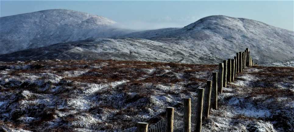
Picture: View East towards Sawel and Dart from Mullaghdoo
Winter has arrived in the Sperrins
by eamonoc
17 Jan 2019
Visited Mullaghdoo today, as part of a 16.4km tek over the Mullaghs, followed Onzy`s track 2570 and added on the walk out to Mullaghdoo and back from Mullaghclogha, much retracing of steps required to get the westerly Mullaghs, but there was a fine dusting of snow on the tops today. Total time taken approx 4hs, ascent 765m descent 777m. Linkback: mountainviews.ie/summit/1423/comment/20338/
Read Less
Read More
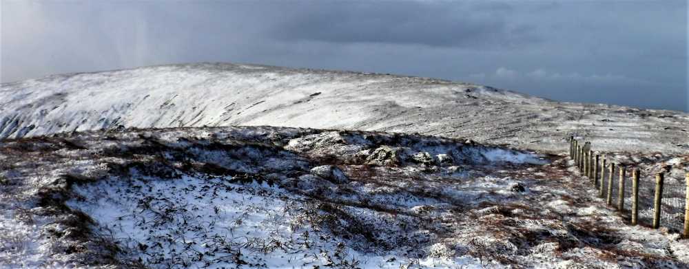
Picture: Viiew to Mullaghclogha, 2nd highest top in Sperrins
Use of MountainViews is governed by conditions and a privacy policy.
Read general information about the site. Opinions in material here are not necessarily endorsed by MountainViews.
Hillwalking is a risk sport. Information in comments, walks, shared GPS tracks or about starting places may
not be accurate for example as regards safety or access permission. You are responsible for your safety and your permission to walk.
See the credits and list definitions.


 Our Facebook page.