This website uses cookies, which are small text files that the website puts on your device to facilitate operation. Cookies help us provide a better service to you. They are used to track general user traffic information and to help the website function properly.
Feature count in area: 9, all in Donegal,
OSI/LPS Maps: 2
Highest Place: Knockalla 363m
Starting Places (13) in area Donegal North: Coshia, Crocknagrauv, Crocknamarrow, Crocknapisha, Glenvar, Lough Cor Road, Lough Hanane, Lurganboy Wind Farm, Mevagh Cross, Narrow Step, Stella Maris Meevagh, Trá na Rossan, Trá na Rossan Hostel
Summits & other features in area Donegal North: Cen: Rosguill: Crocknasleigh 163m, Ganiamore 207m E: Fanad: Cashelmore 149m, Knockalla 363m, Murren Hill 227m, Crockdonnelly 152m, Craigcannon 357m, Drumavohy Hill 153m W: Horn Head: Croaghnamaddy 252m
Note: this list of places may include island features such as summits, but not
islands as such.
Drumavohy Hill, 153mHill Droim an Bhothaigh A name in Irish,
Place Rating ..
Ir. Droim an Bhothaigh [logainm.ie], 'ridge of the crofter', Donegal County in Ulster province, in Binnion Lists, Droim an Bhothaigh is the 1470th highest place in Ireland.
Grid Reference C23378 42534,
OS 1:50k mapsheet 2 Place visited by: 12members, recently by: AntrimRambler, eamonoc, finkey86, Peter Walker, David-Guenot, sandman, chalky, Harry Goodman, Fergalh, osullivanm, simon3, Garmin
I visited this place: NO (You need to be a logged-in member for this.)
Longitude: -7.633394, Latitude: 55.229259, Easting: 223378, Northing: 442534,
Prominence: 100m, Isolation: 1.9km ITM: 623322 942513 Bedrock type: Whitish quartzite with pebble beds, (Slieve Tooey Quartzite Formation) Notes on name: Droim an Bhothaigh / Drumavohy is the name of a townland in the parish of Clondavaddog. We are not aware of a specific name for this hill, but as the townland name refers to a hill, it also seems suitable as a name for this peak.
Short or GPS IDs, 6 char: DrmvHl, 10 char: DrmvhyHil Linkback: https://mountainviews.ie/summit/1345/
Gallery for Drumavohy Hill (Droim an Bhothaigh) and surrounds
Summary
for Drumavohy Hill (Droim an Bhothaigh):
Low but wild hill with coastal views.
Summary created by simon3
2014-05-27 09:54:50
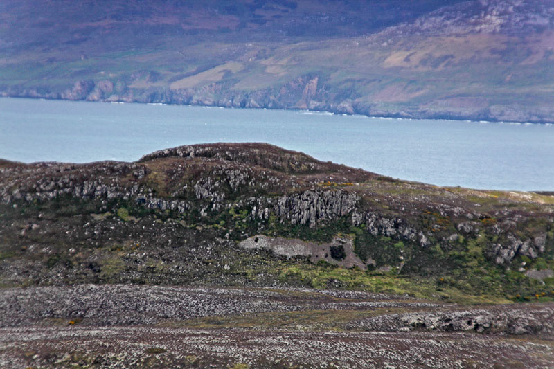
Picture: Drumavohy from the west, with Urris Hills over Lough Swilly.
Although just scraping into MV's lists with an estimated prominence of 100m this summit has the feel of somewhere high, remote and wild.
One place to start is at Nar St (C2393 4201) where there is space for 1 or 2 cars. Immediately north of here is a minor driveable but untarred road, which starts uphill allowing you to gain height quickly. Follow this as far as it goes and then head for the summit over rough boggy ground and near a reed bed.
Views from the top include Lough Swilly - to the west is Murren Hill with its large telecoms installations. Don't miss Lough Doira, a scenic lake on the way up.
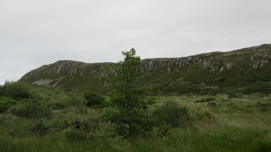
Picture: Approaching the W slopes of Drumavohy Hill.
Drumavohy: a hill with character !!
by David-Guenot
3 Oct 2015
Parked alongside the road at Cr'pish (C2337 4173), which is probably not the best option, but left enough room for any vehicle to pass. Followed the farm track immediately to the right; it veers to the left at some point, and I soon forgot any temptation to continue straight uphill, as the sign on the gate was clear: beware of the bull. So I stayed on the main track, which soon joins another track. Took a right turn, passing by a derelict house and soon the steep W slopes of Drumavohy were visible. Finally turned right, on a wet track and headed straight uphill (a short, but surprisingly very steep climb !!) avoiding a few crags. Did not enjoy much of the views, as the weather had turned cloudy, but the little I could see was nice, with Stocker Strand and the Knockalla ridge visible to the S, Cnoc na Boirne to the W and the W coast of Inishowen to the E. I tried to take a shortcut on the way back in order to avoid the wet portion of track, but it was worse, as the vegetation was a bit dense and the ground as wet... To sum it up: a wee hill with character !! Linkback: mountainviews.ie/summit/1345/comment/18345/
Use of MountainViews is governed by conditions and a privacy policy.
Read general information about the site. Opinions in material here are not necessarily endorsed by MountainViews.
Hillwalking is a risk sport. Information in comments, walks, shared GPS tracks or about starting places may
not be accurate for example as regards safety or access permission. You are responsible for your safety and your permission to walk.
See the credits and list definitions.


 Our Facebook page.