Cookies. This website uses cookies, which are small text files that the website puts on your device to facilitate operation. Cookies help us provide a better service to you. They are used to track general user traffic information and to help the website function properly.

Click to hide this notice for 30 days.
Welcome to MountainViews
If you want to use the website often please enrol (quick and free) at top right.
Overview
Detail
Zoom: ??
For more map options click on any overview map area or any detail map feature.
Detail Map Features
Find Suggested Walks
Find hill, mountain, island, coastal feature.
Videos
Recent Contributions
Get Notifications

GR 92: Estartit to l'Escala

Meikle Bin: Long trek to summit

GR 92: Roses to Cadaques

Cort-ma Law East Top: Do not climb in the rain !

GR 92: Cadaques to Port de la Selva

Lecket Hill: Short trek to summit of around 2 Km from Crow road

GR 92: Torroella de Montgri to Begur

Great Knock: Short trek to summit

Little Bin: Tough little climb

Brown Knowe: Straight forward track to the summit

Costa Brava: Estartit to Torroella de Montgri

Silvermines Hydro Project

Conditions and Info
Use of MountainViews is governed by conditions and a privacy policy.
Read general information about the site.
Opinions in material here are not necessarily endorsed by MountainViews.
Hillwalking is a risk sport. Information in comments, walks, shared GPS tracks or about starting places may not be accurate for example as regards safety or access permission. You are responsible for your safety and your permission to walk.
See the credits and list definitions.
Video display
West Clare Area   NE: Burren East Subarea
Place count in area: 14, OSI/LPS Maps: 51, 52, 57, 58 
Highest place:
Slievecallan, 391m
Maximum height for area: 391 metres,     Maximum prominence for area: 365 metres,

Note: this list of places includes island features such as summits, but not islands as such.
Rating graphic.
Knockanes Hill Clare County in Munster Province, in Binnion List, Fossiliferous limestone with Davidsonia Bedrock

Height: 205m OS 1:50k Mapsheet: 52 Grid Reference: R32855 97408
Place visited by 52 members. Recently by: simoburn, dominic divilly, Barrington1978, mehiking, chelman7, JohnRea, amgall, eamonoc, Krzysztof_K, jimmytherabbit, JoHeaney, Damian120, peter1, obrien116, markmjcampion
I have visited this place: NO (You need to be a logged-in member to change this.)

Longitude: -9.00138, Latitude: 53.023446 , Easting: 132855, Northing: 197408 Prominence: 120m,  Isolation: 1.9km
ITM: 532819 697442,   GPS IDs, 6 char: Knc205, 10 char: Knockanes
Bedrock type: Fossiliferous limestone with Davidsonia, (Aillwee Member (upper))

Knockanes is the 1396th highest place in Ireland.

Linkback: https://mountainviews.ie/summit/1286/
COMMENTS for Knockanes 1 of 1  
Follow this place's comments
MountainViews.ie Picture about mountain Knockanes  in area West Clare, Ireland
Picture: Go on, go on, go on.
 
You'll be wanting tea with that!
by paddyhillsbagger  12 Oct 2014
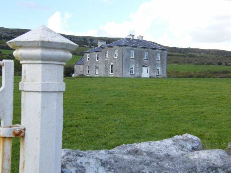
As exasie commented, Father Ted's House is visible from the top of this hill and well worth a visit before or after your climb. It's only a short drive away, R308 959 starA, from the start point.
Be sure to book in advance however.
Visit the website http://www.fathertedshouse.com/
Ah, go on! Linkback: https://mountainviews.ie/summit/1286/comment/17727/
Your Score: Very useful <<  >>Average
 
MountainViews.ie Picture about mountain Knockanes  in area West Clare, Ireland
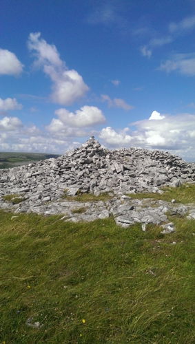
Picture: Summit Area
Quick Bag.
by sandman  17 Mar 2015
If you park at R3338897783 starB (room for one vehicle), you can access the hill thru the farm gate a few metres from you allowing you quick ascent to the summit. No access issues as the hill is located in The Burren National Park. Linkback: https://mountainviews.ie/summit/1286/comment/17604/
Your Score: Very useful <<  >>Average
 
Lovely walk in the heart of the Burren
by Aongus  5 Aug 2020
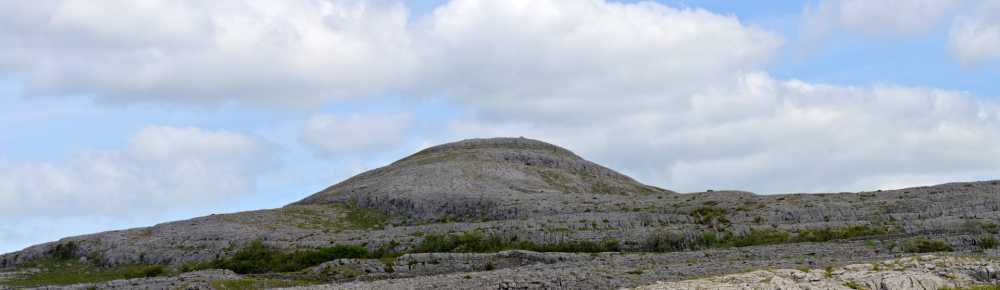
I did the circuit Mullaghmore, Slieve Roe and Knockanes on Bank Holiday Monday. Lovely circuit in an amazing landscape with great views. I followed the Blue route from Loch an Gealláin to summit of Mullaghmore. While the Blue route drops left of Mullaghmore and returns to the start I continued on the short trip to Slieve Roe. A bigger drop to the next col followed by a good pull brought me to Knockanes. I went cross country and picked up the Blue route again under Mullaghmore.

This walk is mainly on exposed limestone, some very short and easy scrambles are required to overcome a few steps so care is needed!

A 3 hour walk to savour. Linkback: https://mountainviews.ie/summit/1286/comment/20839/
Your Score: Very useful <<  >>Average
 
MountainViews.ie Picture about mountain Knockanes  in area West Clare, Ireland
 
Remarkable scenery
by Damian120  12 Jun 2021
A good hike over the traditional Burren karst limestone. A few minor scrambles if approaching from the left. The views are astounding and offer up a picture-postcard setting that encompasses, Mullaghmore, Sliabh Rua and even Father Ted's house. Linkback: https://mountainviews.ie/summit/1286/comment/23173/
Your Score: Very useful <<  >>Average
 
Easy peasy, Ted.....
by exaisle  15 Jul 2014
I climbed this and the nearby Mullaghmore recently.

Not much of a challenge, but the terrain and views of the Burren are fantastic.

The only other notable thing about Knockanes is that you can see Father Ted's house..... Linkback: https://mountainviews.ie/summit/1286/comment/17552/
Your Score: Very useful <<  >>Average
 
(End of comment section for Knockanes .)

Main mapping:
Open Street Map
(Main supplier OpenTopoMap)
Height layer: © MapTiler
MapTiler Logo
British summit data courtesy:
Database of British & Irish Hills
(Creative Commons Licence)
MountainViews.ie, a Hill-walking Website for the island of Ireland. 2500 Summiteers, 1480 Contributors, maintainer of lists such as: Arderins, Vandeleur-Lynams, Highest Hundred, County Highpoints etc