This website uses cookies, which are small text files that the website puts on your device to facilitate operation. Cookies help us provide a better service to you. They are used to track general user traffic information and to help the website function properly.
Feature count in area: 44, by county: Tipperary: 36, Limerick: 8,
OSI/LPS Maps: 52, 53, 54, 58, 59, 60, 65, 66
Highest Place: Keeper Hill 691.6m
Starting Places (31) in area Midlands SW: Ballincurra Hill South, Ballyhourigan Wood Loop Walk, Barnane Lodge, Castlewaller Wood Forest Road, Coillte Knockanroe, Commanealine Wood, Commaun Beg North, Cullaun South, Cummer South, Curreeny Wood, Doonane Forest Carpark, Foildhine Mulkeir Rivers, Glenaneagh Park, Glenstal Wood CP, Gortagarry Hill West, Greenan Cross, Knockadigeen Hill SW, Knockanora East, Knockanully, Knockaviltoge East, Knockfune Wood Bend, Knockmaroe Wood, Knockmehill South, Knockteige SW, Nicker, Raven's Rock, Ring Hill West, River Doonane, The Lookout, Tobernagreana, Upperchurch
Summits & other features in area Midlands SW: Cen: Mauherslieve: Cummer 405m, Foilduff 400m, Knockmaroe 411m, Mauherslieve 543m E: Upperchurch Hills: Knockalough 427m, Knockaviltoge 364m N: Knockshigowna: Knockshigowna 212m NE: Devilsbit: Benduff 455m, Black Hill 228m, Devilsbit Mountain 480m, Gortagarry 458m, Kilduff Mountain 445m, Knockanora 433m NE: Templederry: Ballincurra Hill 403m, Commaun Beg 403m, Cooneen Hill 467m, Coumsallahaun 320m, Knockadigeen Hill 402m NW: Arra Mountains: Corbally Hill 339m, Tountinna 457m NW: Silvermine Mountains: Silvermine Mountains East Top 479m, Silvermine Mountains Far East Top 410m, Silvermine Mountains West Top 489m SE: Hollyford Hills: Falleennafinoga 388m, Foildarg 440m, Glenaneagh 420m, Gortnageragh 418m, Knockastanna 444m, Knockbane 433m, Lackenacreena 413m, Ring Hill 426m, Tooreen 457m SW: Slieve Felim: Cullaun 460m, Derk Hill 236m, Knockroe 204m, Knockseefin 235m, Slieve Felim 427m, Slieve Felim East Top 423m, Slieve Felim South Top 407m W: Keeper Hill: Bleanbeg 368m, Boolatin Top 446.6m, Keeper Hill 691.6m, Knockane 411m, Knockfune 452m
Note: this list of places may include island features such as summits, but not
islands as such.
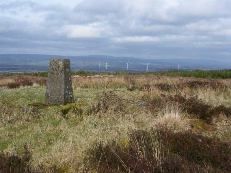
Black Hill, 228mHill
Place Rating ..
, Tipperary County in Munster province, in Binnion Lists, Black Hill is the 1341th highest place in Ireland. Black Hill is the most easterly summit and also the second most northerly in the Midlands SW area.
Grid Reference S16918 82724,
OS 1:50k mapsheet 60 Place visited by: 11members, recently by: Moirabourke, Arcticaurora, conormcbandon, wicklore, Fergalh, eamonoc, muschi, jackill, sandman, chalky, paddyhillsbagger
I visited this place: NO (You need to be a logged-in member for this.)
Longitude: -7.749345, Latitude: 52.895454, Easting: 216918, Northing: 182724,
Prominence: 100m, Isolation: 12.5km, Has trig pillar
ITM: 616865 682761 Bedrock type: Pale & red sandstone, grit & claystone, (Cadamstown Formation)
Short or GPS IDs, 6 char: Blc228, 10 char: Black H228 Linkback: https://mountainviews.ie/summit/1250/
One of the potential problems with the new list of Binnions is access. Black Hill is only really approachable via a working farm and it's field tracks. I asked at the farmhouse near A (S161 825) and was granted permission to walk to the communication mast and trig on the summit, but just how many visitors will the farmer suffer? The track up starts behind the cow sheds and leads up to a boggy plateau giving fine views across the M7 to the Slieve Blooms as well as the controversial Monaincha Wind Farm. There are plans for many more of these wind farms in the Midlands and a growing campaign against them. There are also fine views over to the Devilsbit range. Only a hill for list tickers. Linkback: mountainviews.ie/summit/1250/comment/15906/
Use of MountainViews is governed by conditions and a privacy policy.
Read general information about the site. Opinions in material here are not necessarily endorsed by MountainViews.
Hillwalking is a risk sport. Information in comments, walks, shared GPS tracks or about starting places may
not be accurate for example as regards safety or access permission. You are responsible for your safety and your permission to walk.
See the credits and list definitions.


 Our Facebook page.