This website uses cookies, which are small text files that the website puts on your device to facilitate operation. Cookies help us provide a better service to you. They are used to track general user traffic information and to help the website function properly.
Feature count in area: 65, all in Kerry,
OSI/LPS Maps: 78, 83, 84, 85, EW-KNP, EW-R
Highest Place: Stumpa Dúloigh 784m
Starting Places (66) in area Dunkerron Mountains: Ballaghasheen Coilte, Ballaghasheen Pass Viewpoint, Ballaghbeama Gap, Bohacullia, Bridia Valley End, Cahersavane Road, Cahersavane Schoolhouse, Cloon Lough NE, Cloon Lough SE, Coad Cemetery, Coad Road End, Com an Chiste, Coomaclarig Bridge, Coomnahorna River, Coomyanna Bridge, Dereenavurrig, Derreendarragh Church, Derrynane Quay, Dunkerron Mid, Eagles Lough Access Trailhead, Esknaloughoge Forest Trailhead, Fermoyle Farm, Foot Stick Ford Road, Gap of Dunloe Head of, Glashaknockbrassel Stream, Glasheenoultagh Stream, Gortaclohane Lane End, Gortaclohane Lane NE Branch, Gortagowan Wood, Gowlane School Ruin, Gowlanes Wood, Graces Landing, Inchimore West, Isknagahinney Lough E, Kenmare Bridge, Knockanamadane, Knockanaskill N, Knocknasullig, Knocknsallagh Bridge, Laghtacallow, Lissatinnig Bridge Boreen, Looscaunagh Lough W, Lough Barfinnihy CP, Lough Brin S, Lough Coomeen SE, Lough Dromtine NE, Lough Dromtine SE, Lough Fada N, Lough Iskanamacteery N, Lough Iskanamacteery NW, Lough Reagh N, Maghanlawaun Bridia Valley, Molls Gap, Ochtiabh Road, Poulacapple, River Owroe Source, River Sneem Fermoyle Loop, Rossacoosane Mid, Sahaleen Bridge, Scarriff Island, Shamrock Farmhouse B&B, Sneem, Tooreenboy Lough, Tooreennafersha Mid, Tooreennafersha South, Waterville Promenade
Summits & other features in area Dunkerron Mountains: Knocknagantee Near West Top 628m Cen: An Bheann Mhór: An Bheann Mhór 674.7m, An Bhinn Láir 514m, Coomcallee 648.9m, Beann na Stiocairí 673.1m, Coomnahorna 590m, Glanbeg 485.8m, Slievenashaska 578m, Slievenashaska South Top 565.4m Cen: Knocknagantee: Knockmoyle 682.1m, Finnararagh 667m, Cnoc Breasail 591m, Knocknagantee 674.3m, Knocknagantee West Top 553m, Coomnacronia 636m, Coomura Mountain 666m Cen: Mullaghanattin: An Cnoc Riabhach 534m, Beann 752m, Beann Far SW Top 636.2m, Beann NE Top 692m, Beann South Top 639m, Beann SW Top 657m, Sallagh 570m, Mullaghanattin 773m, Mullaghanattin East Top 594m, Sallagh South-West Top 543m E: Kenmare: Gortamullin 205m, Knockanaskill 356m, Letter South 362m N: Knocknacusha: Knocknacusha 547m NE: Knocknabreeda Ridge: Crossderry 489m, Knocknabreeda 569m, Mothaillín 506m NE: Knocknagapple: Bascadh 595m, Bascadh West Top 569m, Boughil 631m, Cnoc na gCapall 639m, Knocklomena 641m NE: Stumpa Dúloigh: Broaghnabinnia 745m, Knockaunanattin 569m, Knockaunanattin West Top 466.1m, Stumpa Dúloigh 784m, Stumpa Dúloigh SE Top 780m, Stumpa Dúloigh SW Top 663m SW: Caherdaniel: Farraniaragh Mountain 468m, Eagle Hill 155m, Reenearagh 162m, Beenarourke 304m, Knocknasullig 117m, Cahernageeha Mountain 498.7m SW: Coad ( Castle Cove ): Beenrour 418m, Eagles Hill 549m, Mullaghbeg 509m SW: Coomduff: Coomduff 244m SW: Deenish: Deenish Island (2) 144m SW: Esknaloughoge: Esknaloughoge 416m, Esknaloughoge North Top 420m SW: Scarriff: Scarriff Island 252m SW: Sneem: An Bheann Mhór 309.3m, Dereenavurrig Hill 261m, Knockanamadane 270m, Knocknafreaghane 316.5m, Knocknagullion 413m SW: Staigue: Staigue Top 459m, Staigue NE Top 435m
Note: this list of places may include island features such as summits, but not
islands as such.
Dereenavurrig Hill, 261mHill
Place Rating ..
, Kerry County in Munster province, in Binnion Lists, Dereenavurrig Hill is the 1259th highest place in Ireland.
Grid Reference V66700 64200,
OS 1:50k mapsheet 83 Place visited by: 11members, recently by: Pizzagirl, chelman7, eamonoc, conormcbandon, Fergalh, daitho9, mallowman, chalky, trekker, ciarraioch, Conor74
I visited this place: NO (You need to be a logged-in member for this.)
Yep, it's a heartbreaker going from Beann Mhór. Contemplated it before...then thought naaaaa.
Did it from the Sneem side. Leave car where road forks and there is a house on the corner, near point C on the map above. Don't be tempted to stay on the road and get nearer, as you just come to a formidable locked gate with keep out signs, and have to either reverse for ages or do a 14 point turn on a narrow lane. The walk crosses farmland for the first 15 minutes so a few fences to get over and keep an eye out for animals. Would suspect it could get fairly wet, did it during our very dry summer. After that, it's open country and about 30 minutes to the top, where there is a small collection of dishes and a low mast, but apart from that some really wonderful views. Linkback: mountainviews.ie/summit/1202/comment/17747/
Read Less
Read More
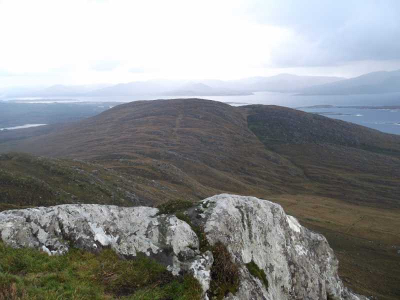
Picture: View from An Bheann Mhór towards Dereenavurrig
Beautiful Place, DREADFUL terrain
by ciarraioch
11 Nov 2014
Nearly got fooled by this one, all 261m of it. Roughest terrain I've encountered and that's including the area south of Lough Cloon. In November 2014, we went for what we thought was a 'jolly' starting at EsknaTrailhd (V635 651) as per three5four0, going across Beann Mhór, Dereenavurrig and diverting to explore the wild country to the southeast near the western mouth of the Sneem inlet A (V68237 63114). Six hours later we arrived back to the second car at B (V67920 65225) as darkness closed in. Impossible to make progress due to rock bench followed by gulley and/or swamp followed by rock bench, and so on and on. To make matters worse, it would appear that the former East German Border personnel were drafted in to put up the fencing. It would have been impossible to navigate this terrain in darkness. Would definitely NOT recommend our route. If you have to do it, I would suggest returning directly along the grain of the land from the summit of Derrenavurrig towards our finishing point. Linkback: mountainviews.ie/summit/1202/comment/17744/
Read Less
Read More
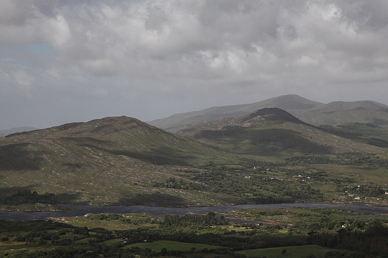
Picture: Dereenavurrig to the left, An Bheann Mhór to the right.
Use of MountainViews is governed by conditions and a privacy policy.
Read general information about the site. Opinions in material here are not necessarily endorsed by MountainViews.
Hillwalking is a risk sport. Information in comments, walks, shared GPS tracks or about starting places may
not be accurate for example as regards safety or access permission. You are responsible for your safety and your permission to walk.
See the credits and list definitions.


 Our Facebook page.